


Los 7
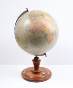
Table Globe
Table Globe, paper printed and described in German on original ebonized stand around 1900. 40 cm high.
Table Globe, paper printed and described in German on original ebonized stand around 1900. 40 cm high.
Columbus Globe, paper with colour printed card, on metal base. Berlin around 1960.
Measures approx. 36 x 22 inches, foxing and yelling on edges
A rare John Miller 3-inch pocket globe, Scottish, published 1793,cartouche printed A NEW GLOBE of the Earth By John Miller Mathematical Instrument...
A 2 ¾-inch terrestrial pocket globe after Herman Moll, English, circa 1775,the rectangular cartouche inscribed A Correct Globe With The New Disco...
ANSON, GEORGE, BARON. 1697-1762. A Voyage Around the World, in the Years MDCCXL, I, II, III, IV. London: For the author, 1749. 4to (245 x 196 mm)...
Middle East.- Fraser (James) The History of Nadir Shah, formerly called Thamas Kuli Khan, second edition, engraved frontispiece, folding engraved ...
POCKET GLOBE; FOREST, J. [Globe Terrestre.] Paris: Forest, Géographe-Éditeur, 17 Rue de Buci, c.1930. A 3 inch (7.7 cm) diameter pocket globe off...
Hungary.- Speed (John) The Mape of Hungari..., carte-a-figure map, eight costumed figures to the vertical margins, four oval vignettes of principa...
Topography. Novus XVII Inferioris Germaniae(..) Merian. 1659. Provinciarum Typus. Caspar Merian, “Topographia Germaniae Inferioris” published by C...
Spain.- Laborde (Alexandre de) A View of Spain, 5 vol., 29 engraved maps, some folding, a few vol. with book labels, some leaves spotted or browne...
World.- Bowdler (Thomas) Letters Written in Holland, in the Months of September and October, 1787..., first edition, 2 folding engraved maps, titl...
World.- Levasseur (Victor) Atlas National Illustre des 86 Departements et des Possessions de la France Divise par Arrondissements, Cantons et Comm...
Erdglobus.Herausgegeben von Kartogr. Institut der Verlagshandlung von Dietrich Reimer. (Andrews u. Steiner) 1943, Masstab 1:38.000 000. Holzbodenp...
Britain.- Camden (William) Viri Clarissimi Britannia, sive florentiss Regnorum Angliæ, Scotiæ, Hiberniæ ..., title with woodcut device, 18 folding...
Britain.- Cary (John) Cary's New and Correct English Atlas, engraved title, engraved dedication, 47 engraved maps hand-coloured in outline, tissue...
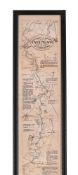
Britain.- Railways Handkerchief Map (circa 1850s) The Railways in Great Britain, Also the Line of Navigation From the Principal Sea Ports to Both ...
England.- Fuller (Thomas) The History of the Worthies of England, first edition, engraved portrait frontispiece, 12pp. 18th century index at end, ...
Ireland.- Taylor (Alexander) A New Map of Ireland..., engraved map with original hand-colouring, sheet 738 x 623 mm., dissected and mounted on lin...
Kent.- Speed (John) Kent with her Cities and Earles described and observed, county map with inset plans of Rochester and Canterbury, engraving wit...
Kent.- Symonson (Philip) A New Description of Kent...., the tractes of Ryuers, Rylles and creeks with the trendinge of the Sea-Shore be more natur...
London.- Ogilby (John) The Road from London to Aberistwith...; The Continuation of ye Road from London to Aberistwith, Plate ye Second...; The Con...
River Thames.- Pine (John) Thamesis Descriptio Anno 1588, after Robert Adams (c.1530-1595), engraving, from a copy drawn by Mr. Joseph Ames, 8 Apr...
Photolitho,Measures 40 x 30 inches
THE OARSMANS AND ANGLERS MAP OF THE THAMES Mounted, framed and glazed 175 x 14cm overall
Howitt (Samuel) [A New Work of Animals, Principally Designed from the Fables of Æsop, Gay, and Phædrus], lacking title, but with manuscript index,...
Nationalsozialismus - Konzentrationslager - Plan obozu Koncentracyjnego "Gusen" Austrii kolo Lincu. 1:2880. Lichtdruck. Gezeichnet v. M. Kurasniew...
Royal Justiciar to Henry III.- Basset (Philip, justiciar and royalist nobleman, d. 1271) Copy of a charter, granted in 1268 by Sir Henry Longchamp...
Kelvin & Hughes Compass, in metal box. Movable. 20th Century. 8 cm diameter.
Fast against the French enemy.- Queen Anne. By the Queen, a Proclamation, for a General Fast...for disappointing the boundless ambition of France,...
Measures approx. 36 x 22 inches, foxing and yelling on edges
Johnson (Samuel) A Dictionary of the English Language, 2 vol., fifth edition, titles in red and black, vol. 1 lacking all after 12Z2, initial leav...
Alter kolorierter Kupferstich mit Darstellung des Bistums Hildesheim nebst Umland von Johann Janssonius (1588 - 1664) aus dem Jahr 1647; Doppelsei...
Seltener, quadratischer Kupferstich des Stadtkerns von Göttingen; Darstellung des Stadtkerns mit Wall, wohl im 17. Jhd.; war mehrfach gefaltet; Ra...
Alter Merian Kupferstich von 1654 mit Darstellung der "Stad und Festung Nienburg - an der Weser"; hinter Passepartout gerahmt; Maße ca.: Bild: 21x...
Maps of France 1881 "Le Ministre De La Guerre", original case.
TANNER, HENRY S. United State of America. Philadelphia: H.S. Tanner, 1832. Engraved map, approximately 61,8 x 48,4 in, with hand-colored territor...
CHATELAIN, HENRI. 1684-1743. Carte De La Nouvelle France.... [Amsterdam: 1719.] Hand-colored engraved map, 420 x 490 mm. Matted and framed. Not e...
ORTELIUS, ABRAHAM. 1527-1598. Americae sive novi orbis, nova descriptio. [Antwerp]: Ortelius, 1587 [but 1591]. Engraved map with hand-coloring, a...
NEW ENGLAND MAP. Colton's Massachusetts, Connecticut, Rhode Island. New York: G.W. & C.B. Colton & Co., 1879. Engraved map with hand-colored boun...
ZATTA, ANTONIO. 1757-1797. La Pensilvania, la Nuova York, il Jersey settentrio[na]le.... Venice: Antonio Zatta, 1778. Hand-colored engraved map, ...
CONNECTICUT AREA MAPS. A group of two maps of Farmington and Plainville, from Atlas of Hartford and Tolland Counties, Connecticut, F.W. Beers, 186...
Juvenilia.- A Present for A Little Girl, engraved hand-coloured vignette on title, 27 brightly hand-coloured wood-engraved illustrations (3 full-p...
Albert Einstein, born on March 14, 1879, in Ulm, in the Kingdom of Württemberg in the German Empire, was one of the most influential scientists o...
Game.- Wallis (John) Wallis's New Game of Universal History and Chronology, spiral track with 137 portraits and scenes around a portrait of the Pr...
Topography, Groningen, publisher: J. Oomkes. Grote Markt seen to the west, with town hallView of the facade of the town hall in Groningen, 1820-18...
Topography. America, South America / Suriname / Guyana / French Guyana / Brazil / El Dorado; Janssonius / Hondius - Guiana sive Amazonum region - ...
Jan VAN CAMPENHOUT (1907-1972) 'City view by Night'Dimensions: (W:60 x H:70 cm)
Asien - Indonesien - Molluken. "Moluccae Insulae celeberrimae". Mit altem Grenz- und Flächenkolorit, Kupferstichkarte, G. Blaeu in Amsterdam, um 1...
Australien und Ozeanien - Sotzmann, Daniel Friedrich. Karte des Grossen Oceans gewöhnlich Das Süd Meer genannt, nebst allen neuen Entdeckungen in ...
JOSEF ALBERS (1888-1976) Homage to the square Colored print on paper Publisher: Gemini G.E.L., Los Angeles, California, c.1966 Measures 7.50 X 7....
Deutschland - Berlin - Britz, N. Plan vom Dorf und Schloss zu Glienicke bei Potsdam. Manuskriptkarte von N. Britz, Berlin, um 1875. Blattgröße: 39...
Deutschland - München - Hollar, Wenzel. Monachium avilica sedes Ducum Bavariae. Gesamtansicht aus der Vogelschau. Kupferstich von WH (Wenzel Holla...
Poster titled "Matterhorn Bobsled" 54" x 36" approximate sizeSome wear, backed on linen, some staining/creases, tears, etc.
Himmelsglobus von Carl Rohrbach. Berlin, um 1896, bezeichnet "Himmelsglobus von Dr. Carl Rohrbach, D. Reimer Berlin (Hoefer&Vohsen)", der Globus a...
Seltener Mondglobus von Paul Räth. Leipzig, 1963, bezeichnet mit "Räths Mondglobus, Durchmesser 33 cm, Maßstab 1:10400000, Die Namen der Formation...
Himmelsglobus von Robert Henseling. Berlin, ca. 1920, bezeichnet "Dietrich Reimers Himmelsglobus, bearbeitet von Robert Henseling", der Globus als...
Induktions- oder Schieferglobus. Deutschland, um 1920, ohne Herstellerbezeichnung, der Globus als mit Gips überzogene Pappmaché-Kugel, die Kontine...
Seltenes Lunarium von Ernst Schotte. Berlin, um 1877, der Globus bezeichnet "Die Erdkugel nach den neuesten u. besten Quellen bearbeitet, Berlin E...
Mondglobus Paul Räth. Leipzig, 1976, "Räths Erdmondglobus", das Kartenbild entworfen vom Kartographen Hellmuth Wolf im VEB Räthgloben-Verlag Leipz...


![POCKET GLOBE; FOREST, J. [Globe Terrestre.] Paris: Forest, Géographe-Éditeur, 17 Rue d...](https://portal-images.azureedge.net/auctions-2024/bonham10894/images/1d4d34d2-06f7-4c2c-a840-b15300783efc.jpg?h=175)
![Hungary.- Speed (John) The Mape of Hungari..., engraved map, 1626 [but c.1676]](https://portal-images.azureedge.net/auctions-2024/forum-10418/images/5bef1aa6-8f11-4f28-9b94-b15400e43335.jpg?h=175)


![Ireland.- Taylor (Alexander) A New Map of Ireland..., [c.1790s].](https://portal-images.azureedge.net/auctions-2024/forum-10418/images/ec86e9e5-e7a2-4639-ae48-b15400e481d6.jpg?h=175)


![CHATELAIN, HENRI. 1684-1743. Carte De La Nouvelle France.... [Amsterdam: 1719.]](https://portal-images.azureedge.net/auctions-2024/bonham10926/images/184d5f4b-af1d-466b-9196-b155000e2273.jpg?h=175)
![ORTELIUS, ABRAHAM. 1527-1598. Americae sive novi orbis, nova descriptio. [Antwerp]: Ortelius, 15...](https://portal-images.azureedge.net/auctions-2024/bonham10926/images/00394e5a-9d41-4bca-a34e-b155000e2071.jpg?h=175)

![ZATTA, ANTONIO. 1757-1797. La Pensilvania, la Nuova York, il Jersey settentrio[na]le.... Venice:...](https://portal-images.azureedge.net/auctions-2024/bonham10926/images/3505b891-d55b-4d40-a8f9-b155000e2dee.jpg?h=175)


