4
Cook, James und James King: A Voyage to the Pacific Ocean. Nur Atlasband Cook, James und James
1/2


Auctioneer has chosen not to publish the price of this lot
Berlin-Grunewald
Description
Cook, James und James King: A Voyage to the Pacific Ocean. Nur Atlasband
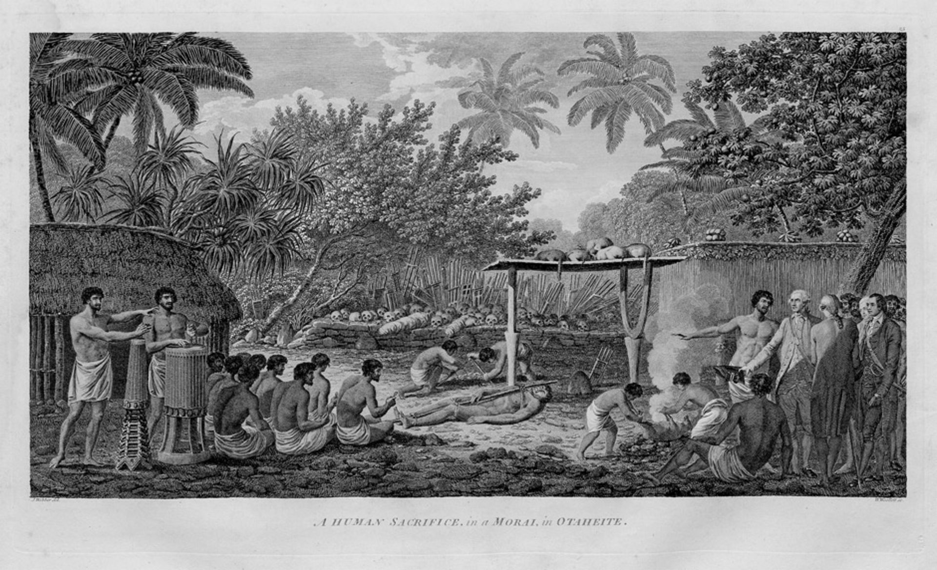
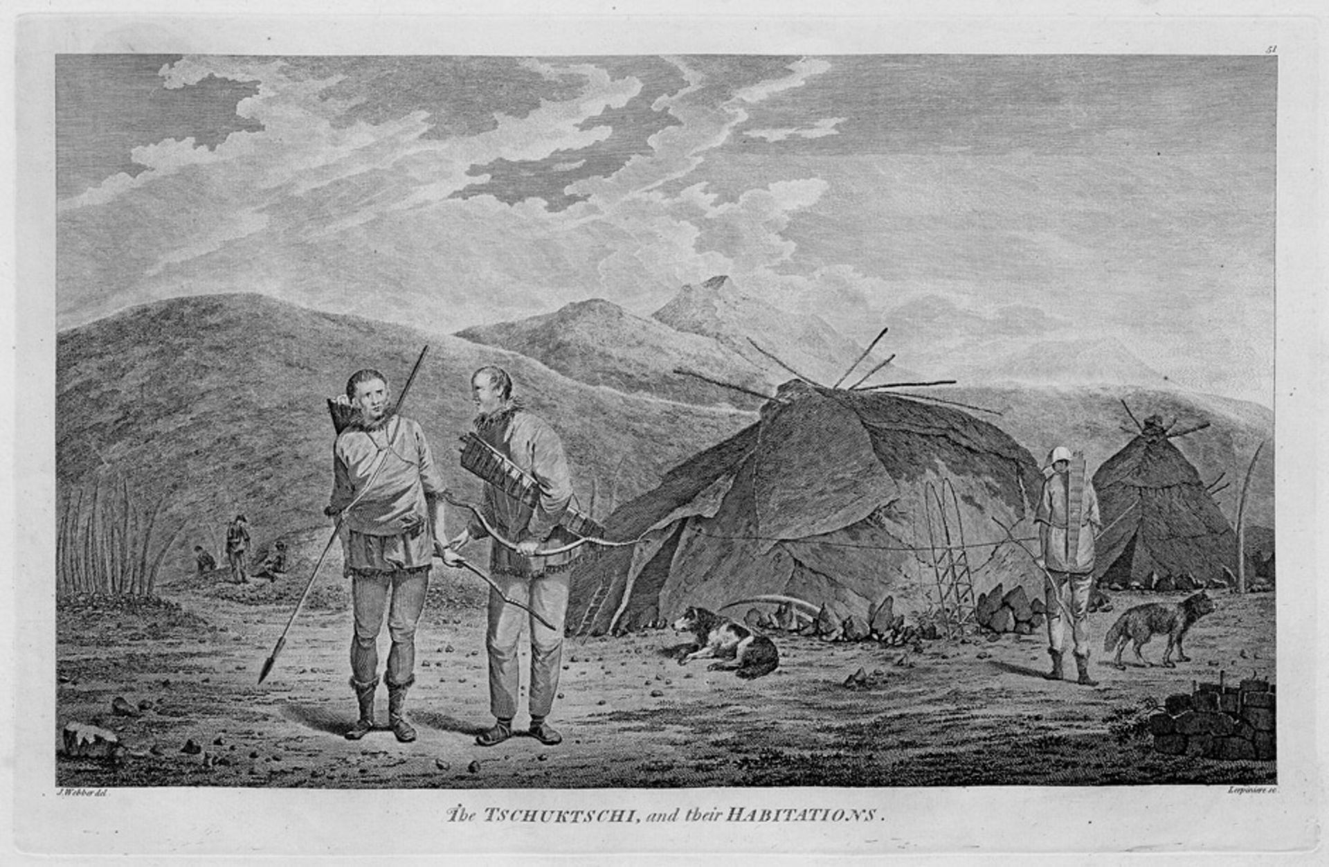
Cook, James und James King. A Voyage to the Pacific Ocean. Undertaken, by the Command of His Majesty, for making Discoveries in the Northern Hemisphere. To determine the Position and Extent of the West Side of North America; its Distance from Asia; and the Practicability of a Northern Passage to Europe. Performed under the Direction of Captains Cook, Clerke, and Gore, in his Majesty's Ships the Resolution and Discovery. In the Years 1776, 1777, 1778, 1779, and 1780. Nur Atlasband mit insges. 60 Tafeln, dreifach gefalteter gestochener Weltkarte und "Chart of the N. W. coast of America" (Doppelblatt). 55,5 x 40 cm. Halbleder d. Z. (etwas beschabt, Rücken gelöst, liegt bei). (London, Strahan und Cadell, 1784).
Beddie 1543. Cox I, 63. Henze I, 713. Holmes 47. Mitchell 63. Nat. Maritime Mus. Cat. London 586. Vgl. Cat. Nederl. Histor. Scheepvart Mus. Amst. 138 und Du Rietz 209ff. – "This third voyage differed from the other two in that the scene of discovery shifted from the South Seas to the North Pacific and the west coast of North America, and had as one of the objectives the attempt at a Northwest Passage to Europe. On the way to the North Pacific the voyagers touched at the Sandwich Islands, ... later called the Hawaiian Islands, where Cook met his death on his return from the North" (Cox).
Neben den beiden Karten sind folgende Tafeln vorhanden: 4, 6-8, 10, 11, 14-18, 20-23, 25-29, 31, 33-35, 38-40, 42, 43, 45-52, 54, 56-58, 60-68 und 70-78. Alle Tafeln nach J. Webber gestochen, die große Weltkarte von W. Palmer und die Karte mit dem Küstenprofil von Nordamerika von T. Harmar gestochen. – Teils unbedeutend stockfleckig bzw. vereinzelt leicht wasserrandig. Eine Tafel mit sorgfältig hinterlegtem Einriss. Der separat beigelegte Rücken mit irrigem Rückenschild "Hunter's Voyage".
Auction Details
Shipping
T&Cs & Important Info
Ask seller a question
Cook, James und James King: A Voyage to the Pacific Ocean. Nur Atlasband
Cook, James und James King. A Voyage to the Pacific Ocean. Undertaken, by the Command of His Majesty, for making Discoveries in the Northern Hemisphere. To determine the Position and Extent of the West Side of North America; its Distance from Asia; and the Practicability of a Northern Passage to Europe. Performed under the Direction of Captains Cook, Clerke, and Gore, in his Majesty's Ships the Resolution and Discovery. In the Years 1776, 1777, 1778, 1779, and 1780. Nur Atlasband mit insges. 60 Tafeln, dreifach gefalteter gestochener Weltkarte und "Chart of the N. W. coast of America" (Doppelblatt). 55,5 x 40 cm. Halbleder d. Z. (etwas beschabt, Rücken gelöst, liegt bei). (London, Strahan und Cadell, 1784).
Beddie 1543. Cox I, 63. Henze I, 713. Holmes 47. Mitchell 63. Nat. Maritime Mus. Cat. London 586. Vgl. Cat. Nederl. Histor. Scheepvart Mus. Amst. 138 und Du Rietz 209ff. – "This third voyage differed from the other two in that the scene of discovery shifted from the South Seas to the North Pacific and the west coast of North America, and had as one of the objectives the attempt at a Northwest Passage to Europe. On the way to the North Pacific the voyagers touched at the Sandwich Islands, ... later called the Hawaiian Islands, where Cook met his death on his return from the North" (Cox).
Neben den beiden Karten sind folgende Tafeln vorhanden: 4, 6-8, 10, 11, 14-18, 20-23, 25-29, 31, 33-35, 38-40, 42, 43, 45-52, 54, 56-58, 60-68 und 70-78. Alle Tafeln nach J. Webber gestochen, die große Weltkarte von W. Palmer und die Karte mit dem Küstenprofil von Nordamerika von T. Harmar gestochen. – Teils unbedeutend stockfleckig bzw. vereinzelt leicht wasserrandig. Eine Tafel mit sorgfältig hinterlegtem Einriss. Der separat beigelegte Rücken mit irrigem Rückenschild "Hunter's Voyage".
Valuable Books, Decorative Prints & Autograph Letters
Sale Date(s)
Venue Address
Erdener Str. 5 a
Berlin-Grunewald
14193
Germany
For Galerie Bassenge delivery information please telephone +49 (0)30 89380290.