Refine your search
Sale Section
Category
- Arms, Armour & Militaria (125)
- Books & Periodicals (59)
- Maps (44)
- Collectables (16)
- Prints (6)
- Photographs (5)
- Stamps (5)
- Oil, Acrylic paintings & Mixed Media (3)
- Sporting Memorabilia & Equipment (3)
- Cameras & Camera Equipment (2)
- Entertainment Memorabilia (2)
- Ethnographica & Tribal Art (2)
- Writing Instruments (2)
- Bank notes (1)
- Classic Cars, Motorcycles & Automobilia (1)
- Coins (1)
- Drawings & Pastels (1)
- Furniture (1)
- Islamic Works of Art (1)
- Metalware (1)
- Models, Toys, Dolls & Games (1)
- Musical Instruments & Memorabilia (1)
- Watches & Watch accessories (1)
- Wines & Spirits (1)
Filtered by:
- Show only bulk lots
- List
- Grid
-
285 item(s)/page
A subscription to the Price Guide is required to view results for auctions ten days or older. Click here for more information


Large Formal Hoffmann Photograph of Adolf Hitler with Ink Signature, black and white image of the German leader in famous pose as taken by the NSD...

Original Film Clips from Heinrich Hoffmann (Hitler's Official photographer). These are small 8mm original individual sections from his colour film...

Two Original WWII Period German Cinefilms, One German seaplanes Training film (Lehrfilm) & second is an Anti Aircraft Defence Unit. Both in origin...
World At War Original Material Relating to this Ground Breaking and Acclaimed Thames TV Series
"World At War" Original Material Relating to this Ground Breaking and Acclaimed Thames TV Series from a retired TV Executive. Includes large numbe...

Queen Elizabeth and Prince Phillips 1954 Tour of Australia. Fascinating "Official" red and gilt Phot
Queen Elizabeth and Prince Phillips 1954 Tour of Australia. Fascinating "Official" red and gilt Photograph Album compiled by a member of the SS Go...

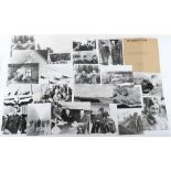
Small collection of photographs
Small collection of photographs, some press including Princes Margaret at a "Ball" 30-4-82, Housewives join the Smithfield war 1956, Two images o...

The Road from Ipswich Suffolk to Norwich.. Copper Engraved, hand coloured, believed Plate 74 from Britannia by Ogilby no date believed 1675 45cms ...

Watercolours & Pen and Ink Drawings. 2nd Lieut. Later Captain John Bryant. Well executed drawing of British troops marching dated 12th September ...

"Seymour" Three Humorous Home Guard Pen & Ink Drawings, with links to Bexhill HG. Original drawin in 1942 these are more modern prints on card ea...

Great War Parliamentary War Savings Committee Poster No15 “BACK THEM UP”, shows image of a gentleman in suit getting money from his pocket with a ...

Original WWII Poster "A Few Careless Words May End In This…" ref 751-5667 HM Stationary Office. A few minor chip and very short tears along crease...

Russian Posters
Russian Posters, graphic images, World War II period, Titles include "The So-called ,, Higher Race" ,Meeting over Berlin, Pictorial Presentation o...

Fantastic Example of a 2nd Battalion Royal Sussex Regiment Embroidery, fine example dating from the early part of the 20th century, with crossed ...

Original Artwork of Normandy and D-Day Interest by G.H.Davis, the well known Artist whose realistic portrayal of aircraft, vehicles, ships, many o...

Original Artwork by G.H.Davis Illustrating the Rhine River from Wesel to Coblenz, together with an inset image of six Rhine bridges demonstrating ...

Original Artwork by G.H.Davis Illustrating the Infra-Red Technology used by the Germans at the end o
Original Artwork by G.H.Davis Illustrating the Infra-Red Technology used by the Germans at the end of World War II. Of the 8 individual drawings m...
Original Artwork by G.H.Davis illustrating Parachute Flares both in operation and with his excellent cutaway illustrations. Signed by Davis and da...

Original Artwork by G.H.Davis, View of Lake Bizerta and the town of Bizerta and the surrounding area. Probably drawn to support article on Allied ...

Original Artwork by G.H.Davis Mix of Images including Magnetic mines and counter measures, use of heavier bombs by the RAF up to 22,000 lbs, Rocke...

Atlas of Australia
Atlas of Australia, large scale detailed maps showing Mineral resources, Climatic Regions etc 18 sheets,

Survey of Egypt 1930/1932 Series of 5 linen maps, includes Maghagha, Samalut, El Mansura, Alexandria etc. Scale 1:100.000 c.70cms x c.50cms. Some ...
Mixed Group of US War Department Maps, Fiji Islands, 1943 1 inch to 1 mile, Nanuya, Ndakuinuku & Nasau. Also New Britain Mt Talawe (Special Map), ...

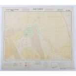
Series of Original Provisional Maps of the Admiralty Islands in the Bismarck Sea, the scene of an American invasion in 1944 against the Japanese. ...


Set of 16 Maps of Jamaica
Set of 16 Maps of Jamaica, all 1:125,000 US Army and dated 1944 & 1948 second Edition AMS E621 etc. c.55cms x c.50 cms Paper, accession stamps to...

Various Paper Maps of Aegean Islands, namely Skiros, Isola Di Calchi, Yioura,(2 copies), Andikithira, Kea etc. one All dated 1944, War Office, Sc...

GSGS Maps
GSGS Maps, Germany 1:250,000 WWI/WWII Period, also Crete/Khania 7 sheets in all
Maps Egypt, Cairo etc
Maps Egypt, Cairo etc. Interesting maps of Port Said,(small) Luxor & Karnak, Sidi Barani, various scales 1:100,000, 1:10,00 and dates 1922, 1933 &...

Survey of Egypt 1922
Survey of Egypt 1922, 1:25,000 Includes Sanhur el Madina, Damanhur etc. 8 sheets in all,

Maps Wehrgeologische Wassrekarte Vorderere, Egypt 1:20,000 1933 Includes Ismalia, El Kossaima and El Arisch. 3 sheets,

Maps Spain 1:50,000 1929 onwards
Maps Spain 1:50,000 1929 onwards Includes Betanzos and Pedrola c.45 sheets,

Greece 1:75,000 WWI period 8 sheets. Includes Inerti, Toponslar and Zarkos,

US Army Palau Islands 1:25,000 c.WWII period. Includes Peleliu, Ngarmoked NW & Angaur SE Etc., 7 sheets ...[more]

Maps, GSGS4072 Europe (Air) 1:500K. WWII Period, includes Cadiz, Bremen, Polotsk etc., 9 linen & 2 paper maps, ...[more]

Maps GSGS4386 Egypt 1:250K WW2 Period, includes Salum-Tobruich, El Haseiat, Sidi Barrani-Matruh, Dernia, Derna etc. Particularly interesting 8 in ...

Maps,GSGS4567 Sweden 1:300K WW2 Period, 7 sheets, generally good condition

Maps, Rijksdienst Voor Het National Plan (Holland), c 1947, 27 sheets see images,

Maps, Zusamendruck aus der Karte des Deutschen Reich, 1:100K Includes Kreis Kolberg-Korlin, Kreis Rastenburg, Kreis Heilsberg etc. 25 sheets,
Collection of German Maps, Sonderausgabe VIII 1941 Etc. All of various African locations and 1,500,000 scale, ncluding Grosse Sandwuste, 1941, Tiz...

Maps, Einheitsblatt, Sonderausgabe 1:100K WW2 Period, includes Koslin-Kolberg-Belgard & Umgeburg von Wittenberge etc. 26 in all, ...[more]

Maps, Deutsche Heereskarte Grossdeutschland, c:100K. c.1944, includes Statzow etc. 7 sheets in all,

Maps, GSGS 4346 Central Europe & Belgium/France 1:200K WWII. Includes Army/Air Force Tilsit, also Passau, Kolberg & Stettin etc, 35 sheets ...[mo...

Maps, GSGS 4332 Belgium/NE France 1:,100K WWII Period. Includes Rheims, Arlon, Liege & Masesyck. 4 in all, ...[more]

Maps, GSGS 2758 Europe WW2 Period etc., 1.1M some linen includes Sofiya, Istanbul, Warsaw, Hamburg 73 sheets,

Maps, Greek Islands 1:50K WWII Period, includes Gavdhos, Andikithira etc.7 sheets

Maps. Important full set of Crete Scene of the first major Airborne invasion in 1941 & Partisan activity for the rest of the war. 1944 GSGS 4426 3...

Maps, AMS G621 Africa 1942
Maps, AMS G621 Africa 1942 1:125K Includes Senegal 18 sheets

Maps, Holland 1:25K TDN M833 Ministry of war Original produced c.1935 reprinted 1c.1954 Includes Deventer, Veenden etc. c.57 sheets in all

Maps, GSGS 4233 Morocco 1:50K WWII Period, includes El Kansera etc. 6 Sheets in all,

Maps, Agean Islands 1:50K MDR 611/8213 & 6171/8225 Wartime Editions c. 20 sheets including Anafi, Kinolos & Lesvos, ...[more]

Maps, Eastern Europe. Sonderausgabe 1933-41 Grossblatt 1:100K includes Arnswalde, Porohy, Passau & Tarnopol etc. 35 maps in all, ...[more]

Maps, Rumania WW2 Period
Maps, Rumania WW2 Period. GSGS 4417 1:100K includes Raducaneni, Palancia & Adjud etc. 85 maps in all, ...[more]

Maps, France GSGS 1944,
Maps, France GSGS 1944, 1:50K c.12 sheets,

Maps, France GSGS 4249 WW2 Period. 1:100K A wide range of areas covered, including Chateaudun, Lisieux Bernay. Neutchatel & St. Malo c,54 Sheets ...

Maps. AMS M641 Czechoslovakia WW2 Period. Includes Tabor, Jihlawa, Plzen & Furth etc. 52 sheets in all, ...[more]

Generalkarte de Mittle Europa 1:200K Balkan/Jugo/Turkey 1940/41 Some excellent maps, including Sofia and Istanbul etc. see images. 68 maps in all,

Maps. Deutsche Heeresgitter Baustoffkarte des Europaischen Russland Wartime dates, 1:300K Includes Gomel & Mogilew etc. 14 sheets in all, ...[mo...

Maps AMS T791 1st Editions
Maps AMS T791 1st Editions 1:50K Bismarck Archipeligo, one of Gazelle with an aerial photograph as part of the map, etc. 7 sheets,

Maps GSGS 4416 Central Europe
Maps GSGS 4416 Central Europe 1:100 K 1943-4, 8 Sheets,

Maps GSGS 4145 1:50K Portugal 1942 32 Sheets,
-
285 item(s)/page