Refine your search
Sale Section
Category
Filtered by:
- Category
- List
- Grid
-
185 item(s)/page
A subscription to the Price Guide is required to view results for auctions ten days or older. Click here for more information
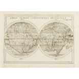
![World.- Münster (Sebastian) La Figure du Monde Universel, [c. 1552-68].](https://portal-images.azureedge.net/auctions-2019/forum-10193/images/000e5f00-4a0f-4f02-a6a3-ab12009d8c37.jpg?w=155&h=155)

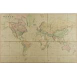
World.- Münster (Sebastian) La Figure du Monde Universel, Munster's world map for the 1550 edition of Cosmographia by David Kandel, oval projectio...
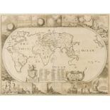
![World.- Mercator (Rumold) Orbis Terrae Compendiosa Descriptio, [circa 1587 but slightly later].](https://portal-images.azureedge.net/auctions-2019/forum-10193/images/4ce69d74-24fc-4b35-bcf0-ab12009d29ea.jpg?w=155&h=155)
World.- Mercator (Rumold) Orbis Terrae Compendiosa Descriptio, [circa 1587 but slightly later].
World.- Mercator (Rumold) Orbis Terrae Compendiosa Descriptio, highly decorative world map, a condensed version of Rumold's father's world map of ...
World.- Quad (Matthias) Typus orbis terrarum ad imitationem universalis gerhardi Mercatoris..., …
World.- Quad (Matthias) Typus orbis terrarum ad imitationem universalis gerhardi Mercatoris..., early map of the World derived from Mercator's pla...
World.- Genesis flood.- Moxon (Joseph) A Map of all the Earth and how after the flood it was …
World.- Genesis flood.- Moxon (Joseph) A Map of all the Earth and how after the flood it was divided among the sons of Noah, map of the World, wit...
World.- Alexander the Great.- De L'Isle (Guillaume) Alexandri Magni Imperium et Expeditio, 1731; …
World.- Alexander the Great.- De L'Isle (Guillaume) Alexandri Magni Imperium et Expeditio, large map illustrating Alexander the Great's conquests ...
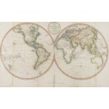
World.- Capt. James Cook.- Jefferys (Thomas) Western Hemisphere; Eastern Hemisphere, a pair, …
World.- Capt. James Cook.- Jefferys (Thomas) Western Hemisphere; Eastern Hemisphere, a pair of hemisphere world maps showing the first voyage of C...
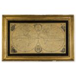
World.- Needlework.- Anonymous (1800) A Map of the World, According to the Latest Discoveries, 1800.
World.- Embroidered Map.- Anonymous (1800) A Map of the World, According to the Latest Discoveries, double-hemisphere world map with vignettes in ...
World.- Capt. James Cook.- Russell (John) Map of the World Shewing the Tracks & Discoveries of …
World.- Capt. James Cook.- Russell (John) Map of the World Shewing the Tracks & Discoveries of Capt. Cook, double-hemisphere world map, engraving ...
![World.- Homann Heirs. Die Erde in Zwey Halbkugeln, [c. 1813-1830].](https://portal-images.azureedge.net/auctions-2019/forum-10193/images/5bfd2019-a8ef-40c0-ba83-ab12009d1e5a.jpg?w=155&h=155)
World.- Homann Heirs. Die Erde in Zwey Halbkugeln, double-hemisphere world map, engraving with hand-colouring, platemark 430 x 610 mm. (17 x 24 in...
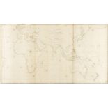
World.- Norie (John William) To the Officers in the Honorable East India Company's Service This …
World.- Norie (John William) To the Officers in the Honorable East India Company's Service This Outline Chart Intended for their Use to prick-off ...
World.- Weimar Geographisches Institut. Westlicher Planiglob Der Erder; Oestlicher Planiglob, Der …
World.- Weimar Geographisches Institut. Westlicher Planiglob Der Erder; Oestlicher Planiglob, Der Erde, a pair of large world maps showing the Ea...
![World.- Russia.- [Cyrillic - Double Hemisphere World Map], 1838.](https://portal-images.azureedge.net/auctions-2019/forum-10193/images/f074b55a-48a2-4b95-973d-ab12009d0788.jpg?w=155&h=155)
World.- Russia.- [Cyrillic - Double Hemisphere World Map], large wall map of the world centred on Russia and showing both Polar regions, with deco...
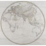
World.- Teesdale (Henry) A New Chart of the World on Mercator's Projection with the Tracks of the …
World.- Teesdale & Co. (Henry, publisher) A New Chart of the World on Mercator's Projection with the Tracks of the Most Celebrated Recent Navigato...
![Africa.- Fries (Lorenz) Tabula II Aphricae, [c. 1522-1535].](https://portal-images.azureedge.net/auctions-2019/forum-10193/images/68a9921b-73ec-471d-a278-ab12009dabbf.jpg?w=155&h=155)
Africa.- Fries (Lorenz) Tabula II Aphricae, Ptolemaic map of the central part of the North African Coastline, with islands in the Mediterranean, b...
![Africa.- Fries (Lorenz) Libyae Interioris Pars, [c. 1522-1535].](https://portal-images.azureedge.net/auctions-2019/forum-10193/images/25d20adb-9610-484c-ac96-ab12009d97ad.jpg?w=155&h=155)
Africa.- Fries (Lorenz) Libyae Interioris Pars, Ptolemaic map showing eastern Libya, Egypt and the Nile Delta, based upon the work of Waldseemulle...
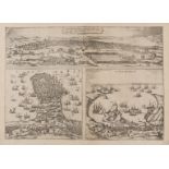
Africa.- Pirates.- Braun (Georg) and Franz Hogenberg. Tunes, Oppidum Barbarie & Regia Sedes... [on …
Africa.- Pirates.- Braun (Georg) and Franz Hogenberg. Tunes, Oppidum Barbarie & Regia Sedes... [on sheet with] Africa, olim Aphrodisium [and] Peno...
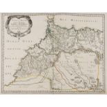
Africa.- Morocco.- Sanson (Nicolas) & Pierre Marriette. Estats et Royaumes de Fez et Maroc; Darha …
Africa.- Morocco.- Sanson (Nicolas) & Pierre Marriette. Estats et Royaumes de Fez et Maroc; Darha et Segelmesse; tires de Sanuto de Marmol &c., m...
![Africa.- Speed (John) Africae, described the manners of their habits, and buildinge..., [1665].](https://portal-images.azureedge.net/auctions-2019/forum-10193/images/3fe06501-33ef-4dd2-816d-ab12009cfc98.jpg?w=155&h=155)
Africa.- Speed (John) Africae, described the manners of their habits, and buildinge..., [1665].
Africa.- Speed (John) Africae, described the manners of their habits, and buildinge..., the first map of Africa prepared by an English cartographe...
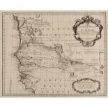
Africa.- Guinea.- Wit (Frederik de) Tractus Littorales Guineae a Promontorio Verde Usque ad Sinum …
Africa.- Guinea.- Wit (Frederik de) Tractus Littorales Guineae a Promontorio Verde Usque ad Sinum Catenbelae, sea chart of the Coast of Guinea, sh...
![Africa.- Jansson (Jan) Regna Congo et Angola, [c. 1660-1700].](https://portal-images.azureedge.net/auctions-2019/forum-10193/images/f3d4b5ad-583c-45ca-965e-ab12009cfa9b.jpg?w=155&h=155)
Africa.- Jansson (Jan) Regna Congo et Angola, engraving with original hand-colouring, on laid paper without watermark, platemark 412 x 500 mm. (16...
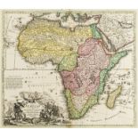
Africa.- Homann (Johann Baptist) Totius Africae Nova Repraesentatio qua Praeter Diversos in ea …
Africa.- Homann (Johann Baptist) Totius Africae Nova Repraesentatio qua Praeter Diversos in ea Status et Regiones, Etiam Origo Nili..., large map...
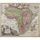
Africa.- Seutter (Matthäus) Africa Iuxta Navigationes et Observationes Recentissimas Aucta Correcta et in sua Regna et Status Divisa, in Lucem Edi...
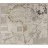
Africa.- Sayer (Robert) Africa According to Mr. D'Anville with Several Additions and Improvements, …
Africa.- Sayer (Robert) Africa According to Mr. D'Anville with Several Additions and Improvements, large wall map with inset chart of the Gold Coa...
Africa.- Senegal.- De L'Isle (Guillaume) Carte de l'Afrique Francoise ou du Senegal Dressee sur un …
Africa.- Senegal.- De L'Isle (Guillaume) Carte de l'Afrique Francoise ou du Senegal Dressee sur un Grand Nombre de Cartes Manuscrites et d'Itinera...
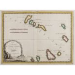
Africa.- Cape Verde.- Cassini (Giovanni Maria) Le Isole Di Capo Verde, the Cape Verde islands with decorative title cartouche in the lower left co...
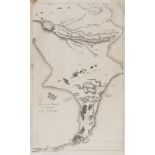
Africa.- Napoleon.- Denon (V.) Plan De La Bataille D'Aboukir, Le 27 Juillet 1799, scarce general plan of the Battle of Aboukir showing the events ...
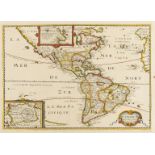
Americas.- Bertius (Petrus) Carte de L'Amerique corrige‚ augmentee; dessus toutes les aultres cy …
Americas.- Bertius (Petrus) Carte de L'Amerique corrige‚ augmentee; dessus toutes les aultres cy devant..., map other Americas based on Hondius`s ...
Americas.- Leth (Hendrik de) Le Nouveau Continent ou l'Amerique Divisee en Septentrionale et …
Americas.- Leth (Hendrik de) Le Nouveau Continent ou l'Amerique Divisee en Septentrionale et Meridionale..., map of North and South America which ...
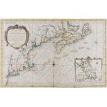
Americas.- Bellin (Jacques Nicolas) Carte Reduite des Costes Orientales de l'Amérique Septentrionale, sea chart of northeast North America, showin...
America & Canada.- Santini (Francois) Carte Generale du Canada, de la Louisiane, de la Floride, de …
America & Canada.- Santini (Francois) Carte Generale du Canada, de la Louisiane, de la Floride, de la Caroline, de la Virginie, de la Nouvelle Ang...
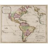
Americas.- Sayer (Robert) A Map of the Whole Continent of America divided into North and South and …
Americas.- Sayer (Robert) A Map of the Whole Continent of America divided into North and South and West Indies with a copious table, large wall ma...
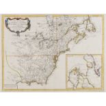
Americas.- Monk (Jacob) New Map of the Portion of North America, Exhibiting the United States and …
Americas.- Monk (Jacob) New Map of the Portion of North America, Exhibiting the United States and Territories, The Canadas, New Brunswick, Nova Sc...
![South America.- Cloppenburg (Johannes) America Meridionalis, [1630].](https://portal-images.azureedge.net/auctions-2019/forum-10193/images/a6adeb24-f1b4-4088-bad3-ab12009cf213.jpg?w=155&h=155)
South America.- Cloppenburg (Johannes) America Meridionalis, from the rare edition of "Atlas Minor", a larger format edition of Mercator's pocket ...
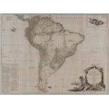
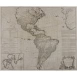
South America.- Sayer (Robert) A Map of South America Containing Tierra-Firma, Guayana, New …
South America.- Sayer (Robert) A Map of South America Containing Tierra-Firma, Guayana, New Granada Amazonia, Brasil, Peru, Paraguay, Chaco, Tucum...
South Atlantic Ocean.- Bellin (Jacques Nicolas) Carte reduite de l'Ocean meridional..., 1739.
South Atlantic Ocean.- Bellin (Jacques Nicolas) Carte reduite de l'Ocean meridional..., map of South America, South Africa and the Southern Atlant...
![Mexico.- Dufour (Auguste-Henri) Mexique Antilles, Etats-Unis, [1868].](https://portal-images.azureedge.net/auctions-2019/forum-10193/images/5d0544bb-1557-4a7e-81aa-ab12009da4f6.jpg?w=155&h=155)
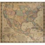
Americas.- Mexico.- Dufour (Auguste-Henri) Mexique Antilles, Etats-Unis, French map depicting the United States, Mexico, Central America, and the ...
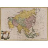
Asia.- Homann (Johann Baptist) Asiae Recentissima Delineatio, qua Status et Imperia Totius Orientis una cum Orientalibus Indiis..., map of Asia sh...
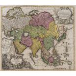
Asia.- Danet (Guillaume) L'Asie Dressee sur de Nouveaux Memoires Assujetis aux Observations …
Asia.- Danet (Guillaume) L'Asie Dressee sur de Nouveaux Memoires Assujetis aux Observations Astronomiq..., map of Asia set within decorative borde...
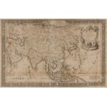
Asia.- Brion de la Tour (Louis) L'Asie, large detailed map showing from the Arabian Peninsula to New Guinea and part of Australia, including India...
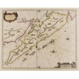
East Indies.- Jansson (Jan) Sumatrae et Insularum Locorumque Nonnullorum Circumiacentium Tabula …
East Indies.- Jansson (Jan) Sumatrae et Insularum Locorumque Nonnullorum Circumiacentium Tabula Nova, map of Sumatra with north oriented to the le...
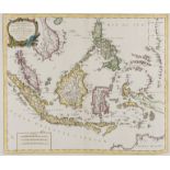
South East Asia.- Santini (Francois) Archipel des Indes Orientales, qui Comprend les Isles de la …
South East Asia.- Santini (Francois) Archipel des Indes Orientales, qui Comprend les Isles de la Sonde, Moluques et Philippines..., detailed map a...
![China.- Blaeu (Willem Jansz. and Johannes) China Veteribus Sinarum Regio, [c. 1640].](https://portal-images.azureedge.net/auctions-2019/forum-10193/images/3dd6fa2c-fd0b-48a3-a568-ab12009dc9b8.jpg?w=155&h=155)
China.- Blaeu (Willem Jansz. and Johannes) China Veteribus Sinarum Regio, map of China, Korea and Japan, with decorative cartouche in the upper ri...
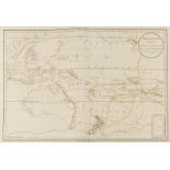
Australasia.- Capt. James Cook.- Djurberg (Daniel) Polynesien (Inselwelt) oder der Funfte Welttheil..., chart of the Western Pacific, Polynesia an...
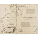
Australia.- Bowen (Emanuel) A complete map of the southern continent, survey'd by Capt. Abel …
Australia.- Bowen (Emanuel) A complete map of the southern continent, survey'd by Capt. Abel Tasman & depicted by order of the East India Company ...
Australia.- Capt. James Cook.- Entrance of Endeavour River, in New South Wales; Botany Bay, in New …
Australia.- Capt. James Cook.- Entrance of Endeavour River, in New South Wales/ Botany Bay, in New South Wales, two maps on one sheet, engraved by...

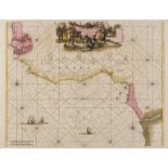
Azores.- Tofino de San Miguel (Vicente) Carta Esferica de las Islas de los Azores o Terceras …
Azores.- Tofino de San Miguel (Don Vicente) Carta Esferica de las Islas de los Azores o Terceras Presentada al Rey Nuestro Senor..., large sea cha...
![Balkans.- Montenegro.- Allodi (P., engraver) Carte du Pays de Montenegro, [c. 1840].](https://portal-images.azureedge.net/auctions-2019/forum-10193/images/8b12aa59-8b80-4d94-af4c-ab12009d1a3a.jpg?w=155&h=155)
Balkans.- Montenegro.- Allodi (P., engraver) Carte du Pays de Montenegro, title in Arabic, Cyrillic, and French, engraving with hand-colouring, sh...

Bermuda.- Blaeu (Willem Jansz.) Mappa Aestivarum Insularum, Alias Barmudas Dictarum, ad Ostia …
Bermuda.- Blaeu (Willem Jansz.) Mappa Aestivarum Insularum, Alias Barmudas Dictarum, ad Ostia Mexicani Aestuary..., fine map of Bermuda based on t...

Biscay.- Basque region.- Blaeu (Willem Jansz.) Biscaia Et Guipuscoa Cantabriae Veteris Pars, …
Biscay.- Basque region.- Blaeu (Willem Jansz.) Biscaia Et Guipuscoa Cantabriae Veteris Pars, map of the coastal Basque country in northern Spain, ...

Black Sea.- Lotter (Tobias Conrad) Nova Mappa Maris Nigri et Freti Constantinopolitani, the Black …
Black Sea.- Lotter (Tobias Conrad) Nova Mappa Maris Nigri et Freti Constantinopolitani, the Black Sea with surrounding coasts, map centred on the ...

Black Sea.- Ottoman Empire.- Rizzi-Zannoni (Giovanni Antonio) Carte de la partie septentrionale de …
Black Sea.- Ottoman Empire.- Rizzi-Zannoni (Giovanni Antonio) Carte de la partie septentrionale de l'Empire Otoman dédiée à Monseigneur le comte d...

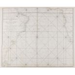
Brazil.- Depot De La Marine. Carte Réduite de la Côte di Brésil; [Coast of Brazil And South …
Brazil.- Depot De La Marine. Carte Réduite de la Côte di Brésil; [Coast of Brazil And South Atlantic Ocean], two detailed scientific sea charts, t...

Brazil.- Depot De La Marine. Carte Réduite de la Côte di Brésil; [Coast of Brazil And South …
Brazil.- Depot De La Marine. Carte Réduite de la Côte di Brésil; [Coast of Brazil And South Atlantic Ocean], two detailed scientific sea charts, t...
![Corsica.- Seutter (Matthäus) Insula Corsica, olim Regni Titulo Insignis..., [c. 1730].](https://portal-images.azureedge.net/auctions-2019/forum-10193/images/19c949e9-aced-4738-bf71-ab12009d2d40.jpg?w=155&h=155)
Corsica.- Seutter (Matthäus) Insula Corsica, olim Regni Titulo Insignis..., detailed map of the island of Corsica, engraving with hand-colouring o...

Egypt.- World War II.- Generalstab des Heeres (publisher) Militärgeographische Angaben über …
Egypt.- World War II.- Generalstab des Heeres (publisher) Militärgeographische Angaben über Ägypten, folder with 6 maps and booklet with geographi...

Eastern Europe.- Ortelius (Abraham) Romaniae, (quae olim Thracia Dicta) Vicinarumq Regionum, uti …
Eastern Europe.- Ortelius (Abraham) Romaniae, (quae olim Thracia Dicta) Vicinarumq Regionum, uti Bulgariae, Walachiae, Syrfiae, Etc. Descriptio. A...

Europe.- Speed (John) Europ, and the Chiefe Cities Contayned Therin, Described; with the Habits of …
Europe.- Speed (John) Europ, and the Chiefe Cities Contayned Therin, Described; with the Habits of Most Kingdoms Now in Use, map of Europe with te...

Europe.- The Rhine.- De L'Isle (Guillaume) The Seat of War on the Rhine being a New Map of the …
Europe.- The Rhine.- De L'Isle (Guillaume) The Seat of War on the Rhine being a New Map of the Course of that River from Strasbourg to Bonn with t...

Europe.- Homann (Johann Baptist) Europa christiani orbis domina in sua Imperia Regna et status …
Europe.- Homann (Johann Baptist) Europa christiani orbis domina in sua Imperia Regna et status exacte..., engraved map with hand-colouring on laid...

Europe.- Gibraltar.- Depot De La Marine. Carte de la Mer Mediterranée en Trois Feuilles, 1745.
Europe.- Gibraltar.- Depot De La Marine. Carte de la Mer Mediterranée en Trois Feuilles, one sheet only, sea chart showing from the Strait of Gibr...
-
185 item(s)/page