Refine your search
Sale Section
Category
Filtered by:
- Category
- List
- Grid
-
23 item(s)/page
A subscription to the Price Guide is required to view results for auctions ten days or older. Click here for more information

Atlases.- Bell & Co. (Allan) A New General Atlas of the World, London, Allan Bell & Co., 1837.
Atlases.- Bell & Co. (Allan, publishers) A New General Atlas of the World; comprising all the Improvements, Railroads, &c. recently introduced int...
Atlases.- Johnston (Alexander Keith) The National Atlas of Historical, Commercial, and Political …
Atlases.- Johnston (Alexander Keith) The National Atlas of Historical, Commercial, and Political Geography, engraved title, 46 double-page engrave...
![Atlases.- Sharpe (John) Sharpe's Corresponding Atlas, [?1849].](https://portal-images.azureedge.net/auctions-2020/forum-10225/images/e0c69aba-c5cc-464d-8b9e-abe400eeda17.jpg?w=155&h=155)
Atlases.- Sharpe (John) Sharpe's Corresponding Atlas, 54 engraved maps by J.W.Lowry, all hand-coloured in outline, 2 double-page (6/7 & 19/20), 2 ...
Atlases.- Smith (Charles) Smith's New General Atlas, 45 hand-coloured engraved maps, C.Smith, 1808.
Atlases.- Smith (Charles) Smith's New General Atlas, engraved calligraphic title, 45 hand-coloured engraved maps, 2 double-page of Germany (number...
Atlases.- Teesdale (Henry, publisher) A New General Atlas of the World, engraved vignette title and 46 hand-coloured maps by John Dower, India dou...
Atlases.- Wilkinson (Robert, publisher) A General Atlas..., engraved vignette title, 48 hand-coloured engraved maps, 2 double-page of world, some ...
![Atlases.- Wyld (James) A General Atlas..., Edinburgh, London & Dublin, John Thomson & Co., [1819].](https://portal-images.azureedge.net/auctions-2020/forum-10225/images/0801c807-d5a3-486f-8a6b-abe400eee01d.jpg?w=155&h=155)
Atlases.- Wyld (James) A General Atlas..., Edinburgh, London & Dublin, John Thomson & Co., [1819].
Atlases.- Wyld (James) A General Atlas..., first edition, engraved vignette title, 2 tables of comparative heights of mountains and lengths of riv...
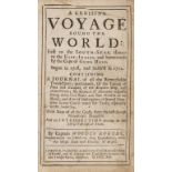
Voyages.- Robinson Crusoe.- Rogers (Woodes) A Cruising Voyage Round the World: First to the South-Seas, thence to the East-Indies, and homewards b...
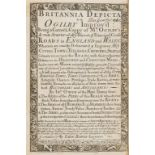
England and Wales.- Owen (John) and Emanuel Bowen. Britannia Depicta, or Ogilby Improv'd, Tho. …
England and Wales.- Owen (John) and Emanuel Bowen. Britannia Depicta, or Ogilby Improv'd, fourth edition, engraved throughout with title within de...
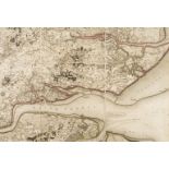
Essex.- Mudge (Lt. Col. William) Part the First of the General Survey of England and Wales, …
Essex.- Mudge (Lt. Col. William) Part the First of the General Survey of England and Wales, containing the whole of Essex, folding engraved map ha...
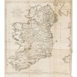
Ireland.- Taylor (George) and Andrew Skinner. Taylor and Skinners's Maps of the Roads of Ireland, …
Ireland.- Taylor (George) and Andrew Skinner. Taylor and Skinners's Maps of the Roads of Ireland, Surveyed 1777, first edition, large folding engr...
![Asia.- Blaeu (Willem Jansz.) Asia Noviter Delineata, [c. 1643].](https://portal-images.azureedge.net/auctions-2020/forum-10225/images/cfb1fc00-725b-4949-8b45-abe400f251dd.jpg?w=155&h=155)
Asia.- Blaeu (Willem Jansz.) Asia Noviter Delineata, map of Asia with carte-a-figures border, and decorated with animals, sea monsters and sailing...
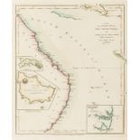
![Asia.- East Indies.- Speed (John) A New Map of East India, [1676].](https://portal-images.azureedge.net/auctions-2020/forum-10225/images/86c28826-be50-46e7-927f-abe400eff932.jpg?w=155&h=155)
Asia.- East Indies.- Speed (John) A New Map of East India, map of south east Asia showing from India, Ceylon, Indonesia, Malay Peninsula, and the ...
Atlases.- Teesdale (Henry, publisher) General Atlas of the World, title and 47 hand-coloured maps, all double-page, India with 2 sheets conjoined ...
![Middle East.- Blaeu (Johan and Willem) Turcicum Imperium, [c. 1638]](https://portal-images.azureedge.net/auctions-2020/forum-10225/images/6ce2aa8d-4cf6-45c4-a116-abe400efd908.jpg?w=155&h=155)
Middle East.- Blaeu (Johan and Willem) Turcicum Imperium, map covering north east Africa, Italy, Greece, Turkey, and Saudi Arabia, with decorative...
![Middle East.- Blaeu (Johan and Willem) Arabia, [c. 1663].](https://portal-images.azureedge.net/auctions-2020/forum-10225/images/44e74f46-3409-4246-a74d-abe400ef20e6.jpg?w=155&h=155)
Middle East.- Blaeu (Johan and Willem) Arabia, map of the Arabian Peninsula, dividing it into the three regions coined by the Romans: Arabia Petra...

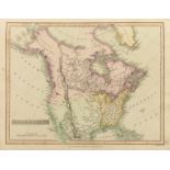
North America.- Mackenzie (Alexander) Voyages from Montreal, on the River St. Laurence, through …
North America.- Mackenzie (Alexander) Voyages from Montreal, on the River St. Laurence, through the Continent of North America, to the Frozen and ...

World.- Seutter (Matthäus) Diversi Globi Terr-Aquei Statione Variante et Visu Intercedente, per …
World.- Seutter (Matthäus) Diversi Globi Terr-Aquei Statione Variante et Visu Intercedente, per Coluros Tropicorum..., double-hemisphere map of th...

British Isles.- Speed (John) The Kingdome of Great Britaine and Ireland, first edition, c. 1610.
British Isles.- Speed (John) The Kingdome of Great Britaine and Ireland, first edition, map of the British Isles with inset panoramic views of Lon...

England & Wales.- Speed (John) The Kingdome of England, first edition map with eight costumed figures in margins, the seas populated with monsters...

England & Wales.- Walker (John) Map of the Inland Navigation, Canals, and Rail Roads with the …
England & Wales.- Walker (John) Map of the Inland Navigation, Canals, and Rail Roads with the Situations of the various Mineral Productions throug...
![Mining.- [Hunt (Thomas)] A Perspective view of a Steam or Fire Engine for draining of mines..., …](https://portal-images.azureedge.net/auctions-2020/forum-10225/images/949bde8b-1594-460c-a7f7-abe400f21ffd.jpg?w=155&h=155)
Mining.- [Hunt (Thomas)] A Perspective view of a Steam or Fire Engine for draining of mines..., …
Mining.- [Hunt (Thomas, late 18th century London-based inventor, active c. 1780-1805)]. A Perspective view of a Steam or Fire Engine for draining ...

Uncle Remus, Nathaniel Hawthorne & Mark Twain.- Osgood (James R.) Autograph Letter initialled …
Uncle Remus, Nathaniel Hawthorne & Mark Twain.- Osgood (James R., publisher in Boston, 1836-92) Autograph Letter initialled "JRO" to Benjamin Holt...
-
23 item(s)/page