Refine your search
Filtered by:
- Category
- List
- Grid
-
58 item(s)/page
A subscription to the Price Guide is required to view results for auctions ten days or older. Click here for more information
![Celestial.- Mariette (Pierre, publisher) Planisfere du Globe Celeste, [c. 1650].](https://portal-images.azureedge.net/auctions-2020/forum-10235/images/79f9478e-0616-463e-9a46-ac3f00c79169.jpg?w=155&h=155)

Celestial.- Mariette (Pierre, publisher) Planisfere du Globe Celeste, double-hemisphere celestial map, said to be from the observations of the Dan...
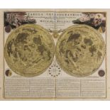
Celestial.- Homann (Johann Baptist) and Johann Gabriel Doppelmayr. Tabula Selenographica..., 1742.
Celestial.- Homann (Johann Baptist) and Johann Gabriel Doppelmayr. Tabula Selenographica, in qua Lunarium Macularum Exacta Descriptio Secundum Nom...
![Celestial.- Solar System.- Homann (Johann Baptist) Systema Solare Et Planetarium, [c. 1740].](https://portal-images.azureedge.net/auctions-2020/forum-10235/images/6a40c804-b273-490e-971b-ac3f00c80516.jpg?w=155&h=155)
NO RESERVE Celestial.- Solar System.- Homann (Johann Baptist) & Johann Gabriel Doppelmayr. Systema Solare Et Planetarium, engraving with hand-colo...
![Celestial.- Woodthorpe (Vincent) The Horizon, [c. 1801-1803].](https://portal-images.azureedge.net/auctions-2020/forum-10235/images/250cedc2-7c05-4b48-ad5f-ac3f00c760bc.jpg?w=155&h=155)
NO RESERVE Celestial.- Woodthorpe (V[incent]) The Horizon, doube-page map of the horizon from Woolsey's ' Cellestial Companion or projects in plan...
![Celestial.- Goodacre (Walter) Map of the Moon, [c. 1910].](https://portal-images.azureedge.net/auctions-2020/forum-10235/images/63a7cdcf-fbb9-49bf-8f89-ac3f00c79550.jpg?w=155&h=155)
NO RESERVE Celestial.- Goodacre (Walter) Map of the Moon, reduced map based on Goodacre's 77" diameter manuscript map of the moon, lithograph, 65...
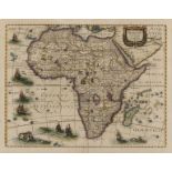
Africa.- Hondius (Henricus) Africae Nova Tabula, detailed and decorative map of the continent from 'Atlas Novus', featuring sailing ships, flying ...
![South Africa.- De L'Isle (Guillaume) Carta Geografica Capo del Buona Speranza, [circa 1750]; and …](https://portal-images.azureedge.net/auctions-2020/forum-10235/images/8de71ed2-3547-4f31-b18a-ac3f00c82bf5.jpg?w=155&h=155)
South Africa.- De L'Isle (Guillaume) Carta Geografica Capo del Buona Speranza, [circa 1750]; and …
South Africa.- De L'Isle (Guillaume) Carta Geografica Capo del Buona Speranza, scarce map showing the second early expansion of the Cape of Good H...
![Algeria.- Seutter (Matthäus) Algercum munita metropolis Regni Algeriani..., [1732]](https://portal-images.azureedge.net/auctions-2020/forum-10235/images/49720dd7-8c8b-464d-949c-ac3f00c8097e.jpg?w=155&h=155)
NO RESERVE Algeria.- Seutter (Matthäus) Algercum munita metropolis Regni Algeriani..., bird's-eye plan of Algiers and its harbour, with two large ...
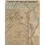
America.- Virginia.- Bacon (George W.) Bacon's New Map of the Seat of War in Virginia and Maryland, showing the interesting localities around Rich...
![Mexico & Texas.- Wyld (James) Republic of Mexico and Texas, [c. 1845].](https://portal-images.azureedge.net/auctions-2020/forum-10235/images/df31279f-e427-471c-80fc-ac3f00c82eb0.jpg?w=155&h=155)
Mexico & Texas.- Wyld (James) Republic of Mexico and Texas, showing Texas as separate from the United States and from Mexico, engraving with hand-...
NO RESERVE Singapore & Malaysia.- Survey Dept. (Federation of Malaya) Johore, 1950, detailed map showing the topography of the region, with Singap...
![Australia.- Gold mining.- Black (Adam and Charles) Austalia [Gold districts marked], [c. 1850]; …](https://portal-images.azureedge.net/auctions-2020/forum-10235/images/fe6a6ce3-8d27-4315-920f-ac3f00c7a438.jpg?w=155&h=155)
Australia.- Gold mining.- Black (Adam and Charles) Austalia [Gold districts marked], [c. 1850]; …
Australia.- Gold mining.- Black (Adam and Charles) Austalia [Gold districts marked], engraving with hand-colouring, sheet 440 x 600 mm (17 1/4 x 2...
![Australia.- Gold mining.- Wyld (James) Gold Regions of Australia, [1854]; and four other maps on …](https://portal-images.azureedge.net/auctions-2020/forum-10235/images/106a65ab-7883-41a0-93ae-ac3f00c84c9f.jpg?w=155&h=155)
Australia.- Gold mining.- Wyld (James) Gold Regions of Australia, [1854]; and four other maps on …
Australia.- Gold mining.- Wyld (James) Gold Regions of Australia, engraving with hand-colouring, sheet 335 x 250 mm (13 1/4 x 9 7/8 in), minor sur...
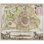
Austria.- Vienna.- Homann (Johann Baptist) Prospect und Grund-Riss der Kayserl. Residenz-Stadt …
Austria.- Vienna.- Homann (Johann Baptist) Prospect und Grund-Riss der Kayserl. Residenz-Stadt Wien mit Negst Anligender Gegend und Neuen Linien u...
![Czech Republic.- Platzer (Thaddeus and Leopold) Grundriss der K. Stadt Karlsbad, [c. 1815].](https://portal-images.azureedge.net/auctions-2020/forum-10235/images/30ace36e-e3ee-415c-905d-ac3f00c77731.jpg?w=155&h=155)
Czech Republic.- Platzer (Thaddeus and Leopold) Grundriss der K. Stadt Karlsbad, plan of Karlovy Vary, engraved by Joh. Berka, with full original ...
![Europe.- Visscher (Nicolas) Europa delineata et recens edita..., [c. 1677].](https://portal-images.azureedge.net/auctions-2020/forum-10235/images/a4898b6d-9673-4603-ab75-ac3f00c847a2.jpg?w=155&h=155)
Europe.- Visscher (Nicolas) Europa delineata et recens edita..., engraved map with early hand-colouring, on laid paper, platemark 440 x 560 mm (17...
France.- Beaulieu (Sébastien Pontault de) 21 plates from 'Les glorieuses Conquêtes de Louis-le-Grand, Roy de France, et de Navarre', including a f...
France.- Fourteen maps including Braun & Hogenberg's plans of Macon and Chalons, 17th and 18th …
France.- A group of maps including Braun & Hogenberg's plans of Macon and Chalons, engraving with hand-colouring, c. 1617; F.de Witt's Generalis L...

France.- Paris.- Vue Generale de l'Exposition Universelle et des Constructions elevees dans le …
France.- Paris.- Vue Generale de l'Exposition Universelle et des Constructions elevees dans le Parc, wood-engraved bird's-eye view of the exhibiti...

France.- Paris.- Crépy (Jean Baptiste) Nouveau Plan Routier de la Ville et Faubourg de Paris, 1763.
France.- Paris.- Crépy (Jean Baptiste) Nouveau Plan Routier de la Ville et Faubourg de Paris, engraving with hand-colouring, sheet 570 x 790 mm (2...

Germany.- Hamburg.- Homann Heirs. Des Heil. Rom. Reichs freye Handels u. Hansee Stadt Hamburg in …
Germany.- Hamburg.- Homann's Heirs. Des Heil. Rom. Reichs freye Handels u. Hansee Stadt Hamburg in einem accuraten Plan u. Prosp., engraved plan a...

Holy Land.- Jerusalem.- Savery (Jacob) De Heylige en Wytvermaerde Stadt Ierusalem Eerst Genaemt …
NO RESERVE Holy Land.- Jerusalem.- Savery (Jacob) De Heylige en Wytvermaerde Stadt Ierusalem Eerst Genaemt Salem, imaginary bird's-eye view of anc...

Holy Land.- Conder (Thomas) A Map of The Land of Canaan, 1799; and 2 others of the region (3)
Holy Land.- Conder (Thomas) A Map of The Land of Canaan, engraving with hand-colouring, 350 x 360 mm (13 3/4 x 14 1/8 in), old folds as issued, ha...

Holy Land.- Clarke (Samuel) The Holy Land, large folding wall map showing from Damascus to Petra, with inset maps of the topography of Jerusalem a...

India.- Wyld (James) Map of the Peninsula of India, from the 19th Degree of North Latitude, to …
India.- Wyld (James) Map of the Peninsula of India, from the 19th Degree of North Latitude, to Cape Comorin, large two-sheet map of India with par...

India & Sri Lanka.- Coronelli (Vincenzo Maria) Penisola dell' Indo di qua del Gange, e l'Isola di …
India & Sri Lanka.- Coronelli (Vincenzo Maria) Penisola dell' Indo di qua del Gange, e l'Isola di Ceilan nell' Indie Orientali Descritta..., map o...

Indonesia.- Stemfoort (J.W.) and J.J. Ten Siethoff. Atlas van Nederlandsch Oost-Indië, 21 maps of …
Indonesia.- Stemfoort (J.W.) and J.J. Ten Siethoff. Atlas van Nederlandsch Oost-Indië, title with inset key map, 21 maps on 16 double-pages, litho...

Italy.- Rizzi-Zannoni (Giovanni Antonio) Li Regni di Sicilia, e Sardegna, colle adiacenti isole di …
Italy.- Rizzi-Zannoni (Giovanni Antonio) Li Regni di Sicilia, e Sardegna, colle adiacenti isole di Corsica, Elba, Malta, e Liparee..., engraving w...

Italy.- Venice.- Laurie & Whittle (publishers) A View from St. Marks Pillar at Venice; A View of …
Italy.- Venice.- Laurie & Whittle (publishers) A View from St. Marks Pillar at Venice; A View of the Bridge on the Canal Reggio, a pair of vue d'o...
![Turkey.- Münster (Sebastian) Constantinopel des Griechischen Keyserchumbs Hauptstatt, [c. 1550].](https://portal-images.azureedge.net/auctions-2020/forum-10235/images/e872ea71-ae5c-46f3-ba50-ac3f00c785f2.jpg?w=155&h=155)
Turkey.- Münster (Sebastian) Constantinopel des Griechischen Keyserchumbs Hauptstatt, [c. 1550].
Turkey.- Istanbul.- Münster (Sebastian) Constantinopel des Griechischen Keyserchumbs Hauptstatt/ im Land Thracia am Moere Gelegen, bird's-eye view...

Middle East.- Red Sea.- d'Anville (Jean Baptiste Bourguignon) Persian Gulph From the Original by …
Middle East.- Red Sea.- d'Anville (Jean Baptiste Bourguignon), After. Persian Gulph From the Original by D'Anville, chart of the Persian Gulf by G...

Middle East.- Cassini (Giovanni Maria) Gli Imperi Antichi Parte Occidentale; Gli Imperi Antichi …
Middle East.- Cassini (Giovanni Maria) Gli Imperi Antichi Parte Occidentale; Gli Imperi Antichi Parte Orientale, two part map of the Turkish Empir...

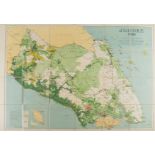
New Zealand.- Reid (John) Map of the Province of Otago New Zealand, hanging lithographic wall map with hand-colouring, 1080 x 980 mm (42 1/2 x 38 ...

Russia.- Sanson (Nicolas) Description de la Tartarie Tiree en Partie de Plusieurs Cartes, 1654; …
NO RESERVE Russia.- Sanson (Nicolas) and Pierre Mariette. Description de la Tartarie Tiree en Partie de Plusieurs Cartes, map of Tartary, showing ...

Russia.- St. Petersburg.- Bowles (John) [View of the Twelve Colleges building and part of the …
Russia.- St. Petersburg.- Bowles (John) [View of the Twelve Colleges building and part of the Merchant's Arcade in St Petersburg], vue d'optique e...

Switzerland.- Collection of 5 maps in cassetta-style frames, including 'Des Kantons Lucern Nordlicher Theil', 'Der Kanton Solothurn', 'Basiliensis...
![Alps.- Matterhorn.- Kümmerly & Frey (publishers) Visp/ Viège-Zermatt-Gornergrat, [c. 1926]; and …](https://portal-images.azureedge.net/auctions-2020/forum-10235/images/e977c216-fd60-40f4-8dcb-ac3f00c77e19.jpg?w=155&h=155)
Alps.- Matterhorn.- Kümmerly & Frey (publishers) Visp/ Viège-Zermatt-Gornergrat, [c. 1926]; and …
Alps.- Matterhorn.- Kümmerly & Frey (publishers) Visp/ Viège-Zermatt-Gornergrat, map of the Swiss and Italian Alps centred on Zermatt, lithograph ...

Atlases.- Speed (John) Title and frontispiece for 'The Theatre of the Empire of great Britaine', …
Atlases.- Speed (John) Title and frontispiece for 'The Theatre of the Empire of great Britaine', two sheets, engravings with full hand-colouring, ...

Atlases.- World.- Black (Adam and Charles) Black's General Atlas of The World, New and Revised …
Atlases.- World.- Black (Adam and Charles) Black's General Atlas of The World, New and Revised Edition, frontispiece with flags of nations, title,...

Arabic atlas.- Brocktorff (Frederico) Atlas, ay majmu' kharitat rasm al-ard..., published in …
Arabic atlas.- Brocktorff (Frederico, Maltese map publisher) Atlas, ay majmu' kharitat rasm al-ard..., 11 hand-coloured lithographic maps, includi...

Game.- Spooner (William, publisher) The Travellers of Europe; with improvements and additions, geographic game board featuring Europe, North Afric...

Game.- Wallis (J. & E.) The Royal Game of British Sovereigns Exhibiting the Most Remarkable Events …
Game.- Wallis (J. & E.) The Royal Game of British Sovereigns Exhibiting the Most Remarkable Events in Each Reign From Egbert to George III, spiral...

England & Wales.- Speed (John) The Kingdome of England, with eight costumed figures in margins, the seas populated with monsters and ships, engrav...

East Midlands.- Speed (John) Rutlandshire, with Oukham and Stanford her bordering Neighbour newely …
East Midlands.- Speed (John) Rutlandshire, with Oukham and Stanford her bordering Neighbour newely described, inset plans of 'Oukham' and 'Stanfor...
![London.- Ogilby (John) The Road from London to Hith in Com. Kent, [circa 1676]; and two other road …](https://portal-images.azureedge.net/auctions-2020/forum-10235/images/c8a5b45b-632e-4111-9c8d-ac3f00c7a10b.jpg?w=155&h=155)
London.- Ogilby (John) The Road from London to Hith in Com. Kent, [circa 1676]; and two other road …
London.- Ogilby (John) The Road from London to Hith in Com. Kent, strip road map with London in the lower left corner, engraving with hand-colouri...

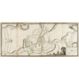
London.- Homann Heirs. Regionis, quae est circa Londinum, specialis repræsentatio geographica, 1741.
London.- Homann Heirs. Regionis, quae est circa Londinum, specialis repræsentatio geographica, map of the environs of London, from Maidenhead to B...

London.- Chiswick.- Bowles (Carington) A View of the Garden of the Earl of Burlington, at Chiswick; A View of Cain & Abel Bird-Cage... in Lord Bur...

London.- Tegg (Thomas) A New Plan of the Cities of London and Westminster, showing from Pentonville to Newington Butts and from Stepney Green to K...

London.- Illustrated London News (The) London in 1842, taken from the summit of the Duke of York's …
NO RESERVE London.- Illustrated London News (The) London in 1842, taken from the summit of the Duke of York's column, two bird's eye views of Lond...
![London.- Illustrated London News (The) [Panorama of the River Thames in 1845]](https://portal-images.azureedge.net/auctions-2020/forum-10235/images/eddd17c0-d1e6-4724-8ded-ac3f00c7478a.jpg?w=155&h=155)
NO RESERVE London.- Illustrated London News (The) [Panorama of the River Thames in 1845], one section only showing from the City of London to Gre...

London.- Newton (William) London Westminster Southwark as in Olden Times shewing the City and …
London.- Newton (William) London Westminster Southwark as in Olden Times shewing the City and Suburbs, large wall map, lithograph printed in colou...

London.- Weller (Edward) London, large nine sheet wall map, from the Weekly Dispatch, lithographs with full hand-colouring, conjoined in 3 horizon...

London.- Bacon (George W.) New Large-Scale Ordnance Atlas of London & Suburbs with Supplementary …
***Please note, the description of this lot has changedLondon.- Bacon (George W.) New Large-Scale Ordnance Atlas of London & Suburbs with Suppleme...
![London.- Bacon (George W.) New Map of London, [c. 1880]; and seven others (8)](https://portal-images.azureedge.net/auctions-2020/forum-10235/images/97e7056b-ae3e-481c-9708-ac3f00c7c70b.jpg?w=155&h=155)
NO RESERVE London.- Bacon (George W.) New Map of London, divided into half mile squares & circles, from Cassell's Old & New London, lithograph wit...

London.- Bacon (George W.) Bacon's New Large Scale Atlas of London and Suburbs with Supplementary …
London.- Bacon (George W., publisher) Bacon's New Large Scale Atlas of London and Suburbs with Supplementary Maps, Letterpress Descriptions and Al...

Oxford.- Speed (John) Oxforshire described with ye Citie and the Armes of the Colledges of ye …
Oxford.- Speed (John) Oxforshire described with ye Citie and the Armes of the Colledges of ye famous university, county map with inset town plan o...

Oxford.- Sayer (Robert) A View of Queen's College (a), University College (b), All Souls College …
Oxford.- Sayer (Robert, publisher) A View of Queen's College (a), University College (b), All Souls College (c), the Steeple of St. Mary's Church ...

Newcastle.- Bowles & Carver (publishers) A South View of Newcastle upon Tyne in the County of …
Newcastle.- Bowles & Carver (publishers) A South View of Newcastle upon Tyne in the County of Northumberland, vue d'optique engraving with full or...
-
58 item(s)/page