Refine your search
Filtered by:
- Category
- List
- Grid
-
35 item(s)/page
A subscription to the Price Guide is required to view results for auctions ten days or older. Click here for more information
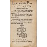

Antonine Itinerary.- Itinerarium Provinciarum; Vibius Sequester: de fluminibus; Publius Victor: de …
Antonine Itinerary.- Itinerarium Provinciarum; Vibius Sequester: de fluminibus; Publius Victor: de Regionibus Urbis Romae; Dionysius Afer: de Situ...
![Africa.- Views of British North Borneo, first edition, [for the British North Borneo Company], …](https://portal-images.azureedge.net/auctions-2021/forum-10247/images/5e293a8b-dd09-4e67-b54e-ac9800d9f8e6.jpg?w=155&h=155)
Africa.- Views of British North Borneo, first edition, [for the British North Borneo Company], …
Africa.- Views of British North Borneo, first edition, map, illustrations, original cloth, [for the British North Borneo Company], 1899 § Beaver (...
![Africa.- Ortelius (Abraham) Presbiteri Iohannis, sive, Abissinorum Imperii Descriptio, [1579].](https://portal-images.azureedge.net/auctions-2021/forum-10247/images/ec75b385-6e4e-4103-8f9f-ac9800d8f5ec.jpg?w=155&h=155)
Africa.- Ortelius (Abraham) Presbiteri Iohannis, sive, Abissinorum Imperii Descriptio, [1579].
Africa.- Ortelius (Abraham) Presbiteri Iohannis, sive, Abissinorum Imperii Descriptio, map of the central African kingdom of the mythical Christi...
![Africa.- Ortelius (Abraham) Barbariae et Biledulgerid, Nova Descriptio, [1580]; and two other …](https://portal-images.azureedge.net/auctions-2021/forum-10247/images/8931e5ff-78b6-452a-83ee-ac9800d91a7b.jpg?w=155&h=155)
Africa.- Ortelius (Abraham) Barbariae et Biledulgerid, Nova Descriptio, [1580]; and two other …
NO RESERVE Africa.- Ortelius (Abraham) Africae Propriae Tabula, in qua, Punica Regna Vides; Tyrios, et Agenoris Urbem, map of the coastline coveri...
![Asia.- Ortelius (Abraham) Asiae Nova Descriptio, [1581].](https://portal-images.azureedge.net/auctions-2021/forum-10247/images/5c34d91c-ac86-4be2-8889-ac9800d96cae.jpg?w=155&h=155)
Asia.- Ortelius (Abraham) Asiae Nova Descriptio, map of Asia showing from the Arabian Gulf, across India, South East Asia, China, and Japan, with ...

Atlas.- d'Anville (Jean Baptiste Bourguignon) Geographie ancienne abregee. Nouvelle edition revue …
Atlas.- d'Anville (Jean Baptiste Bourguignon) Geographie ancienne abregee. Nouvelle edition revue by l'Auteur, title with woodcut vignette of Atla...

Austria.- Ortelius (Abraham) Salisburgensis Iurisdictionis, Locorumque Vicinorum Vera Descriptio …
NO RESERVE Austria.- Ortelius (Abraham) Salisburgensis Iurisdictionis, Locorumque Vicinorum Vera Descriptio Auctore Marco Secznagel Salisburgense,...

Black Sea.- Ortelius (Abraham) Pontus Euxinus. Aequor Iasonis Pulsatum Remige Primum, 1624; and 3 …
NO RESERVE Black Sea.- Ortelius (Abraham) Pontus Euxinus. Aequor Iasonis Pulsatum Remige Primum, map of the black sea centred on Crimea, engraving...
![Cyprus & Aegean Islands.- Ortelius (Abraham) Insular Aliquot Aegaei Maris Antiqua Descrip, [1624]; …](https://portal-images.azureedge.net/auctions-2021/forum-10247/images/668d6a82-51a8-4b2d-8b5a-ac9800da321b.jpg?w=155&h=155)
Cyprus & Aegean Islands.- Ortelius (Abraham) Insular Aliquot Aegaei Maris Antiqua Descrip, [1624]; …
NO RESERVE Cyprus & Aegean Islands.- Ortelius (Abraham) Insular Aliquot Aegaei Maris Antiqua Descrip, large central map of Cyrpus, surrounded by n...
![Denmark & Low Countries.- Ortelius (Abraham) Daniae Regni Typus [on sheet with] Cimbricae …](https://portal-images.azureedge.net/auctions-2021/forum-10247/images/0dde8170-6f9c-4188-ac9f-ac9800d9b664.jpg?w=155&h=155)
Denmark & Low Countries.- Ortelius (Abraham) Daniae Regni Typus [on sheet with] Cimbricae Chersonesi nunc Iutiae, engraving, an excellent impressi...

Europe.- Bertius (Petrus) Imperii Caroli Magni et vicinarum regionum Descriptio, Dedicata et …
Europe.- Bertius (Petrus) Imperii Caroli Magni et vicinarum regionum Descriptio, Dedicata et inscripta Ludovico, large four-sheet map covering the...
![France.- Ortelius (Abraham) Artesia; and 3 other French provincial maps by Ortelius, [1584-1603] …](https://portal-images.azureedge.net/auctions-2021/forum-10247/images/28388a3c-d7e6-4f90-b5e0-ac9800d96187.jpg?w=155&h=155)
France.- Ortelius (Abraham) Artesia; and 3 other French provincial maps by Ortelius, [1584-1603] …
NO RESERVE France.- Ortelius (Abraham) Artesia; and 3 other French provincial maps, showing northern France, from Calais to Cambrai in the south-e...
![France.- Ortelius (Abraham) Provinciae Regionis Galliae Vera Exactissimaque Descriptio, [1609].](https://portal-images.azureedge.net/auctions-2021/forum-10247/images/e5910282-a24e-4629-b41d-ac9800d97866.jpg?w=155&h=155)
France.- Ortelius (Abraham) Provinciae Regionis Galliae Vera Exactissimaque Descriptio, [1609].
NO RESERVE France.- Ortelius (Abraham) Provinciae Regionis Galliae Vera Exactissimaque Descriptio, detailed map showing the coastline of Provence-...
![France.- Ortelius (Abraham) Galliae Veteris Typus, [1624]; Gallia Vetus, [1624] (2).](https://portal-images.azureedge.net/auctions-2021/forum-10247/images/5e8886d3-aa5e-4620-870b-ac9800da344f.jpg?w=155&h=155)
NO RESERVE France.- Burgundy.- Ortelius (Abraham) Burgundiae Comitatus, showing the region just north of Dijon, engraving with hand-colouring, 365...
![Greece.- Ortelius (Abraham) Graecia Sophiani, [1579]; together with Thraciae Veteris Typus, …](https://portal-images.azureedge.net/auctions-2021/forum-10247/images/63dce5b0-28eb-4e5c-9d44-ac9800d95e0a.jpg?w=155&h=155)
Greece.- Ortelius (Abraham) Graecia Sophiani, [1579]; together with Thraciae Veteris Typus, …
NO RESERVE Greece.- Ortelius (Abraham) Graecia Sophiani, map of ancient Greece, western Turkey and the Grecian islands based on the 1545 woodcut m...

Italy.- Cramer (I. A.) Italiae Antiquae et Novae, two engraved maps of Italy, Oxford, Joseph …
NO RESERVE Italy.- Cramer (I. A.) Italiae Antiquae et Novae, two engraved maps of Italy with outline hand-colouring, c.64 x 78 cm (25 x 30½ in.), ...

Italy.- Jaillot (Alexis-Hubert) Le Royaume de Naples divise en toutes ses Provinces dedie a Sa …
Italy.- Jaillot (Alexis-Hubert) Le Royaume de Naples divise en toutes ses Provinces dedie a Sa Majesté Catholique Philippe, V. Roy d'Espagne, larg...
![Italy.- Ortelius (Abraham) Veronae Urbis Territorium, [1584].](https://portal-images.azureedge.net/auctions-2021/forum-10247/images/958b4424-a0a0-42b7-8b68-ac9800d97e2a.jpg?w=155&h=155)
Italy.- Ortelius (Abraham) Veronae Urbis Territorium, map of the vicinity of Verona based on the cartography of Bernardino Brugnoli, engraving on ...
![Italy.- Ortelius (Abraham) Tusciae Antiquae Typus, [1584]; and tow other maps of Italy by Ortelius …](https://portal-images.azureedge.net/auctions-2021/forum-10247/images/9cd0153f-5bf9-4e56-8629-ac9800da09a4.jpg?w=155&h=155)
Italy.- Ortelius (Abraham) Tusciae Antiquae Typus, [1584]; and tow other maps of Italy by Ortelius …
NO RESERVE Italy.- Ortelius (Abraham) Tusciae Antiquae Typus, map of ancient Tuscany, based on Bellarmati's map supplemented by classical sources,...
![Italy.- Ortelius (Abraham) Bononiense Territorium [on sheet with] Territori Vicentini, 1608; and …](https://portal-images.azureedge.net/auctions-2021/forum-10247/images/a13c761e-e09e-427a-b110-ac9800da011a.jpg?w=155&h=155)
Italy.- Ortelius (Abraham) Bononiense Territorium [on sheet with] Territori Vicentini, 1608; and …
NO RESERVE Italy.- Ortelius (Abraham) Bononiense Territorium [on sheet with] Territori Vicentini, two maps, the former centred on Bologna, the lat...

Italy.- Ortelius (Abraham) Ducatus Ferrariensis, Finitimarumque Partium Descriptio Auctore Joan …
Italy.- Ortelius (Abraham) Ducatus Ferrariensis, Finitimarumque Partium Descriptio Auctore Joan Baptista Aleotti, alias l'Argenta, one of the rare...
![Italy & Slovenia.- Ortelius (Abraham) Fori Iulii Accurata Descriptio, [1601].](https://portal-images.azureedge.net/auctions-2021/forum-10247/images/f68cbf9a-ec13-4f00-82c2-ac9800d9fd85.jpg?w=155&h=155)
NO RESERVE Italy & Slovenia.- Ortelius (Abraham) Fori Iulii Accurata Descriptio, showing the northern coastline of the Adriatic, from Venice in th...
![Low Countries.- Ortelius (Abraham) Brabantiae Descriptio, [1601].](https://portal-images.azureedge.net/auctions-2021/forum-10247/images/0ecebe08-807a-46c5-82f0-ac9800d905cc.jpg?w=155&h=155)
Low Countries.- Ortelius (Abraham) Brabantiae Descriptio, detailed map of the Brabant region, with inset map of the area around Mechelen, from Ort...
![Mediterranean.- Ortelius (Abraham) Peregrinationis Divi Pauli Typus Corographicus..., [1601]; and …](https://portal-images.azureedge.net/auctions-2021/forum-10247/images/d26a6bf7-eb82-46e6-979d-ac9800d9bf5c.jpg?w=155&h=155)
Mediterranean.- Ortelius (Abraham) Peregrinationis Divi Pauli Typus Corographicus..., [1601]; and …
Mediterranean.- Ortelius (Abraham) Peregrinationis Divi Pauli Typus Corographicus..., map showing the travels of St Paul across the eastern Medite...
![Mediterranean.- Cyprus & Crete.- Ortelius (Abraham) Cyprus Insula [on sheet with] Candia, olim …](https://portal-images.azureedge.net/auctions-2021/forum-10247/images/2e1627c1-3de6-409d-b4b5-ac9800d95404.jpg?w=155&h=155)
Mediterranean.- Cyprus & Crete.- Ortelius (Abraham) Cyprus Insula [on sheet with] Candia, olim …
NO RESERVE Mediterranean.- Cyprus & Crete.- Ortelius (Abraham) Cyprus Insula [on sheet with] Candia, olim Creta, map of Cyprus and Crete on one sh...
![Middle East.- Ortelius (Abraham) Persici sive Sophorum Regni Typus, [c. 1579].](https://portal-images.azureedge.net/auctions-2021/forum-10247/images/c58f6bce-99fa-4796-9302-ac9800da21c9.jpg?w=155&h=155)
Middle East.- Ortelius (Abraham) Persici sive Sophorum Regni Typus, Persia from the Caspian Sea to the Red Sea with strapwork title cartouche in t...
![Middle East.- Ortelius (Abraham) Turcici Imperii Descriptio, [1584]](https://portal-images.azureedge.net/auctions-2021/forum-10247/images/67c2fc57-7777-4dfd-9d50-ac9800d9f21d.jpg?w=155&h=155)
Middle East.- Ortelius (Abraham) Turcici Imperii Descriptio, second edition of Ortelius's map of the Turkish Empire, derived from the work of Ital...

Portugal.- Ortelius (Abraham) Portugalliae que olim Lusitania, Novissima & Exactissima Descriptio, …
NO RESERVE Portugal.- Ortelius (Abraham) Portugalliae que olim Lusitania, Novissima & Exactissima Descriptio, Auctore Vernando Alvaro Secco, map o...

Russia & Eastern Europe.- Seutter (Matthäus) Mappae Imperii Moscovitici pars Septentrionalis, …
Russia & Eastern Europe.- Seutter (Matthäus) Mappae Imperii Moscovitici pars Septentrionalis, Adornata per Guillielmum de l'Isle..., map of northe...
![Sicily.- Ortelius (Abraham) Siciliae Veteris Typus, [c. 1595].](https://portal-images.azureedge.net/auctions-2021/forum-10247/images/8c3b6cfd-d2a1-4481-ab02-ac9800d914e6.jpg?w=155&h=155)
NO RESERVE Sicily.- Ortelius (Abraham) Siciliae Veteris Typus, map of ancient Sicily, with an inset plan of Syracuse, with three strapwork cartouc...
![Spain & Portugal.- Ortelius (Abraham) Post Omnium Editiones Locupleissima Descriptio, [c. 1584]; …](https://portal-images.azureedge.net/auctions-2021/forum-10247/images/130d4eba-138c-4caf-bb6a-ac9800da05bf.jpg?w=155&h=155)
Spain & Portugal.- Ortelius (Abraham) Post Omnium Editiones Locupleissima Descriptio, [c. 1584]; …
NO RESERVE Spain & Portugal.- Ortelius (Abraham) Post Omnium Editiones Locupleissima Descriptio, map of the Iberian peninsula, showing the Baleari...

Switzerland & Southern Germany.- Ortelius (Abraham) Basiliensis Territorii Descriptio Nova... [on …
NO RESERVE Switzerland & Southern Germany.- Ortelius (Abraham) Basiliensis Territorii Descriptio Nova... [on sheet with] Circulus sive Liga Suevia...

Epping Forest.- Driver (Robert, surveyor) Plan in Four Parts of Waste Lands in the Northern …
Epping Forest.- Driver (Robert, surveyor) Plan in Four Parts of Waste Lands in the Northern Portion of Epping Forest, within the Meaning of the Ep...

NO RESERVE Wales.- Speed (John) Montgomery Shire, county map of Montgomery, with inset town plan in the upper left corner, engraving on laid paper...

Worcestershire.- Map of Childswickham and Murcot, large lithographed map with hand-coloured …
NO RESERVE Worcestershire.- Map of Childswickham and Murcot, large lithographed map with hand-coloured outlines, on paper, linen-backed, small tr...
-
35 item(s)/page