Refine your search
Filtered by:
- Category
- List
- Grid
-
103 item(s)/page
A subscription to the Price Guide is required to view results for auctions ten days or older. Click here for more information
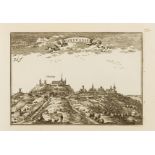

France.- Beaulieu (Chevalier de) [Les Plans et Profils des principales Villes et lieux considerables du Comté de Flandre avec les Cartes generales...
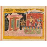
India.- Indian School (late 19th century) Two Ladies in Temple Courtyard, opaque pigments, [late …
India.- Indian School (late 19th century) Two Ladies in Temple Courtyard, opaque pigments on buff paper, with ruled red ink border lines, sheet 16...

Middle East.- Adrichem (Christiaan van) Theatrum Terræ Sanctæ et Biblicarum Historiarum ..., …
Middle East.- Adrichem (Christiaan van) Theatrum Terræ Sanctæ et Biblicarum Historiarum ..., engraved title, trimmed at foot, lacking letterpress ...
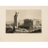
Middle East.- Bartlett (William Henry) & William Purser, &c. Syria, the Holy Land, Asia Minor, &c. …
Middle East.- Bartlett (William Henry) & William Purser, &c. Syria, the Holy Land, Asia Minor, &c. Illustrated, 3 vol., 3 additional engraved titl...

Polar.- Du Chaillu (Paul B.) The Land of the Midnight Sun, 2 vol., first edition, 1881; and …
Polar.- Du Chaillu (Paul B.) The Land of the Midnight Sun, 2 vol., first edition, frontispieces (1 folding), plates and illustrations, large foldi...

Spain.- Italy.- Swinburne (Henry) Travels through Spain, 2 vol., second edition, 1787; and an …
NO RESERVE Spain.- Italy.- Swinburne (Henry) Travels through Spain, 2 vol., second edition, engraved portrait frontispiece, 10 linen-backed foldin...
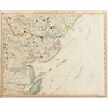
Britain.- Cary (John) Cary's Improved Map of England and Wales, with a considerable portion of Scotland, planned upon a scale of two statute miles...

Britain.- Ogilby (John) and Emmanuel Bowen. Britannia Depitca or Ogilby Improv'd ..., fourth …
Britain.- Ogilby (John) and Emmanuel Bowen. Britannia Depitca or Ogilby Improv'd ..., fourth edition, title page and eight pages of tables, 273 en...

Britain.- Slater (Isaac, publisher) Slater's New British Atlas, comprising the Counties of England …
Britain.- Slater (Isaac, publisher) Slater's New British Atlas, comprising the Counties of England (upon which are laid down all railways complete...

De L'Isle (Guillaume) Atlante novissimo che contiene tutte le parti del mondo, nel quale sono …
De L'Isle (Guillaume) Atlante novissimo che contiene tutte le parti del mondo, nel quale sono esattamente descritti, first vol. only (of 2), engra...
![Delamarche (Charles-François) and others. Composite atlas containing 13 double-page maps, [c.1825]](https://portal-images.azureedge.net/auctions-2021/forum-10286/images/4599faaa-eb7d-4b87-a0b1-adb700c6b3d8.jpg?w=155&h=155)
Delamarche (Charles-François) and others. Composite atlas containing 13 double-page maps, [c.1825]
Delamarche (Charles-François) and others. Composite atlas containing 13 double-page maps, including maps by Robert de Vaugondy, Vivien and Lapie, ...
![Atlases.- Lizars (Daniel) Lizars' Edinburgh Geographical General Atlas, [1842].](https://portal-images.azureedge.net/auctions-2021/forum-10286/images/27681afb-d55f-4cb5-9b19-adb700c86165.jpg?w=155&h=155)
Atlases.- Lizars (Daniel) Lizars' Edinburgh Geographical General Atlas, 68 double-page engraved maps, hand-coloured in outline, with 1 double-page...

Atlases.- Petermann (Augustus) & Rev. Thomas Milner. The Atlas of Physical Geography..., 1851; and …
Atlases.- Petermann (Augustus) & Rev. Thomas Milner. The Atlas of Physical Geography constructed by Augustus Petermann... with Descriptive Letter-...
![Celestial.- [Desnos (Louis-Charles)] Seven plates of globes, armillary spheres and celestial …](https://portal-images.azureedge.net/auctions-2021/forum-10286/images/6192e745-da83-41a6-b75e-adb700c82c27.jpg?w=155&h=155)
Celestial.- [Desnos (Louis-Charles)] Seven plates of globes, armillary spheres and celestial …
Celestial.- [Desnos (Louis-Charles)] Seven plates of globes, armillary spheres and celestial plans, from 'Atlas General et Elementaire pour l´Etud...
![World.- Kitchin (Thomas) A General Atlas, describing the whole Universe, 24 map sections, [c. 1773].](https://portal-images.azureedge.net/auctions-2021/forum-10286/images/03f2bd3d-ccb2-4695-aff8-adb700c6bce0.jpg?w=155&h=155)
World.- Kitchin (Thomas) A General Atlas, describing the whole Universe, 24 map sections, [c. 1773].
World.- Kitchin (Thomas) A General Atlas, describing the whole Universe, letterpress title, with 24 map sections only (of 35), including maps of T...
![World.- Rosaccio (Giuseppe) Orbis Terrae Compendiosa Descriptio, [1598 but c.1713].](https://portal-images.azureedge.net/auctions-2021/forum-10286/images/7dace9cc-9cf0-484b-8479-adb700c72095.jpg?w=155&h=155)
World.- Rosaccio (Giuseppe) Orbis Terrae Compendiosa Descriptio, double-hemisphere world map based on Mercator's map of 1587, originally from Rosa...
![World.- Goos (Abraham) Typus Orbis Terrarum, [c.1630].](https://portal-images.azureedge.net/auctions-2021/forum-10286/images/87013d68-0afd-480a-89d7-adb700c858fb.jpg?w=155&h=155)
World.- Goos (Abraham) Typus Orbis Terrarum, miniature map of the world in two hemispheres, commissioned by Jansson to replace his father in law, ...

World.- Luyts (Jan) Mappe-Monde ou Carte Generale du Globe Terrestre, Representee en Deux Plan-Hemispheres..., double-hemisphere map of the world,...

World.- Chatelain (Henri Abraham) Plan de l'Histoire Universelle, ou l'on voit les Quatre Monarchies du Monde, et Tous les Anciens Etats Aussi Bie...

World.- Brion de la Tour (Louis) and Louis Charles Desnos. Mappe-Monde dressee pour l'Etude de la …
World.- Brion de la Tour (Louis) and Louis Charles Desnos. Mappe-Monde dressee pour l'Etude de la Geographie, relativement aux Auteurs les plus Mo...

World.- Krevelt (A. van) Mappe-Monde ou Description du Globe Terrestre..., double-hemisphere map of the world, with a suggested Northwest Passage,...

World.- Cook's Voyages.- Roberts (Lieut. Henry) & Robert Benard. Carte Generale Offrant Les …
World.- Cook's Voyages.- Roberts (Lieut. Henry) & Robert Benard. Carte Generale Offrant Les Decouvertes Faites Par Le Capitaine Jacques Cook, Fren...

World.- Russell (John) Map of the World, Shewing the Tracks & Discoveries of Capt. Cook, double-hemisphere world map, engraving with outline hand-...

NO RESERVE World.- Wyld (James) The World On Mercator's Projection, engraving with hand-colouring, 660 x 990 mm (26 x 39 in), dissected and mounte...
![America.- Jansson (Jan) and Jodocus Hondius. America noviter delineata, [circa 1623-1632].](https://portal-images.azureedge.net/auctions-2021/forum-10286/images/174b0c81-fbb7-43fc-ad1e-adb700c7b7d8.jpg?w=155&h=155)
America.- Jansson (Jan) and Jodocus Hondius. America noviter delineata, rare example of this impressive map of South and North America, before the...

America.- Phelps (Humphrey) & Edward Hooker Ensign. Phelps & Ensign's Travellers Guide and Map of …
America.- Phelps (Humphrey) & Edward Hooker Ensign. Phelps & Ensign's Travellers Guide and Map of the United States..., large wall map by J. Wells...

America.- Mitchell, Jr. (S. Augustus) The Empire State New York with it's Counties, Towns, Cities, …
America.- Mitchell, Jr. (S. Augustus) The Empire State New York with it's Counties, Towns, Cities, Villages, Internal Improvements, &c, large wall...

Coastal Charts.- Maritime navigation.- Laurie (Richard H.) Laurie's General Chart of the Coasts of …
NO RESERVE Coastal Charts.- Maritime navigation.- Laurie (Richard H.) Laurie's General Chart of the Coasts of Brasil &c., from the River Para to B...

NO RESERVE Asia.- Speed (John) A Newe Mape of Tartary, detailed map showing from Lake Baikal through the regions of present-day Manchuria and Sibe...

NO RESERVE Asia.- Bonne (Rigobert) Carte Generale de l'Asie, ou se trouvert les Decouvertes faites par Bougainville, Danpierre et la Perouse Dress...

Australia.- Hydrographic Office of the Admirality (British) Australia South Coast - Port Phillip, …
Australia.- Hydrographic Office of the Admirality (British) Australia South Coast - Port Phillip, chart of Port Phillip Bay with Melbourne in the ...

Bohemia & Austria.- Jaillot (Alexis-Hubert) Estats de la Couronne de Boheme qui comprennent le …
Bohemia & Austria.- Jaillot (Alexis-Hubert) & Nicholas Sanson. Estats de la Couronne de Boheme qui comprennent le Royaume de Boheme..., map showin...

Central & Eastern Europe.- Bohemia.- Cloppenburg (Johannes) Regni Bohemiae Nova Descriptio, …
NO RESERVE Central & Eastern Europe.- Bohemia.- Cloppenburg (Johannes) Regni Bohemiae Nova Descriptio, a good impression of Pieter Karius' map of ...

China.- Second Opium War.- Anonymous (probably The British Admiralty Office) Plan of the Mouth of …
China.- Second Opium War.- Anonymous (probably The British Admiralty Office) Plan of the Mouth of the Pei-ho River [Hai River, Beijing], manuscrip...

Europe upside down.- Münster (Sebastian) [Europa das ein Drittheil der Erden/nach Gelegenheit …
Europe upside down.- Münster (Sebastian) [Europa das ein Drittheil der Erden/nach Gelegenheit Unsern Zeiten], map of Europe, orientated in reverse...

Europe.- The Rhine.- De L'Isle (Guillaume) The Seat of War on the Rhine being a New Map of the …
Europe.- The Rhine.- De L'Isle (Guillaume) The Seat of War on the Rhine being a New Map of the Course of that River from Strasbourg to Bonn with t...
![France.- Münster (Sebastian) Gallia IIII Nova Tabula, woodcut, [c. 1540]; and 19 others, mainly …](https://portal-images.azureedge.net/auctions-2021/forum-10286/images/6011579e-3b9e-4c71-bb89-adb700c85253.jpg?w=155&h=155)
France.- Münster (Sebastian) Gallia IIII Nova Tabula, woodcut, [c. 1540]; and 19 others, mainly …
NO RESERVE France.- Münster (Sebastian) Gallia IIII Nova Tabula, woodcut map, the place names both Ptolemaic and modern, sheet 310 x 400 mm (12 1/...

France.- Moll (Herman) A New and Exact Map of France Divided into all its Provinces and Acquisitions, according to the Newest Observations, and th...

Germany.- Ortelius (Abraham) Mansfeldiae Comitatus Descriptio. Auctore Tilemanno Stella Sig., …
NO RESERVE Germany.- Ortelius (Abraham) Mansfeldiae Comitatus Descriptio. Auctore Tilemanno Stella Sig., regional map of Germany centered on Mansf...
![Germany.- Homann (Johann Baptist) Six regional maps of Germany, Denmark, and Austria, [c. 1740].](https://portal-images.azureedge.net/auctions-2021/forum-10286/images/5964783a-5e1d-4670-a345-adb700c6c247.jpg?w=155&h=155)
Germany.- Homann (Johann Baptist) Six regional maps of Germany, Denmark, and Austria, [c. 1740].
Germany.- Homann (Johann Baptist) Six regional maps of Germany, Denmark, and Austria, including '... Particulare Territorium' showing Bayern, with...

Germany.- Lotter (Tobias Conrad) Saxoniae Inferioris Circulus; Saxoniae Superioris, two maps, …
Germany.- Lotter (Tobias Conrad) Saxoniae Inferioris Circulus; Saxoniae Superioris, two maps of German states, engravings with original hand-colou...

NO RESERVE Greece.- Speed (John) Greece, engraved map with hand-colouring, on laid paper with armorial watermark, sheet 397 x 514 mm (15 3/4 x 20 ...

Greece.- Central Europe.- Dufour (Auguste-Henri) Carte physique, politique & comparee de la …
Greece.- Central Europe.- Dufour (Auguste-Henri) Carte physique, politique & comparee de la Turquie d'Europe, large folding map in two sections, s...

Hungary.- Ortelius (Abraham) Ungariae Loca Praecipua Recens Emendata atque Edita, per Ioannem …
NO RESERVE Hungary.- Ortelius (Abraham) Ungariae Loca Praecipua Recens Emendata atque Edita, per Ioannem Sambucum Pannonium, Imp. Ms. Historicum. ...

India.- Wyld (James) Map of the Peninsula of India, from the 19th Degree of North Latitude, to …
India.- Wyld (James) Map of the Peninsula of India, from the 19th Degree of North Latitude, to Cape Comorin, large two-sheet map of India with par...

India.- Allen & Co. (William H.) Map of India, from the most recent Authorities, engraved map, by [?]J. Walker, with early hand-colouring, sheet 9...

Ireland.- Ortelius (Abraham) Eryn. Hiberniae, Britannicae Insulae, Nova Descriptio. Irlandt, [c. …
Ireland.- Ortelius (Abraham) Eryn. Hiberniae, Britannicae Insulae, Nova Descriptio. Irlandt, map of Ireland, based on Mercator's 1564 wall map of ...

Ireland.- Nollin (Jean Baptiste) Le Royaume D'Irlande. Divise en Provinces Subdivises en Comtez et …
Ireland.- Nollin (Jean Baptiste) Le Royaume D'Irlande. Divise en Provinces Subdivises en Comtez et en Baronies ..., decorative Jacobite map of Ire...

Ireland.- Beaufort (Daniel Augustus) A New Map of Ireland Civil and Ecclesiastical, First edition, large title and vignette in the upper left corn...

Ireland.- Griffiths (Richard) A General Map of Ireland to Accompany the Report of the Railway …
Ireland.- Griffiths (Richard) and Thomas Larcom. A General Map of Ireland to Accompany the Report of the Railway Commissioners shewing the Princip...

Italy.- Ortelius (Abraham) Perusini agri; exactissima nouissimáque descriptio: auctore Egnatio …
NO RESERVE Italy.- Ortelius (Abraham) Perusini agri; exactissima nouissimáque descriptio: auctore Egnatio Dante, detailed map of Perugia, engravin...

Middle East.- War Office (Geographical Section) Aswan, 1951; and 3 others similar, early to …
Middle East.- War Office (Geographical Section) Aswan, detailed military map of the region, lithograph printed in colours, 630 x 760 mm (24 3/4 x ...
![Middle East.- Arabian Peninsula.- Israel Defence Force (General Staff, [Tel Aviv]) Ha-mizrach …](https://portal-images.azureedge.net/auctions-2021/forum-10286/images/121d289c-0973-4e50-8053-adb700c7f1e2.jpg?w=155&h=155)
Middle East.- Arabian Peninsula.- Israel Defence Force (General Staff, [Tel Aviv]) Ha-mizrach …
Middle East.- Arabian Peninsula.- Israel Defence Forces [Tel Aviv] (General Staff) Ha-mizrach ha-karov [The Near East], map of the Middle East wit...

Netherlands.- Homann (Johann Baptist) Belgii Pars Septentrionalis Communi Nominee Vulgo Hollandia, …
Netherlands.- Homann (Johann Baptist) Belgii Pars Septentrionalis Communi Nominee Vulgo Hollandia, map of the Netherlands with inset portions show...
![Poland.- Seutter (Matthäus) Borussiae Regnum, [c. 1730].](https://portal-images.azureedge.net/auctions-2021/forum-10286/images/2f305063-9bc8-461a-a217-adb700c7d2b6.jpg?w=155&h=155)
Poland.- Seutter (Matthäus) Borussiae Regnum, with inset map of the Principality of Neufchatel, large decorative cartouche centered on a portrait ...

Portugal & Brazil.- Seutter (Matthäus) Portugalliae et Algarbiae Regna cum Confinibus Hispaniae …
Portugal & Brazil.- Seutter (Matthäus) Portugalliae et Algarbiae Regna cum Confinibus Hispaniae Provinc Simul Vero Peculiari Mappa Brasiliae Regnu...

Russia.- Faden (William) The Russian Dominions in Europe, Drawn from the Latest Maps, 1808; and 4 …
Russia.- Faden (William) The Russian Dominions in Europe, Drawn from the Latest Maps, Printed, by the Academy of Sciences, St. Petersburg; Revised...

Sri Lanka.- Münster (Sebastian) Sumatra ein grosse insel so von den alten Geographen Taprobana ist …
Sri Lanka.- Münster (Sebastian) Sumatra ein grosse insel so von den alten Geographen Taprobana ist genent worden, large vignette of an elephant in...
![Switzerland.- Blaeu (Willem Jansz.) Das Wiflispurgergow [1687]](https://portal-images.azureedge.net/auctions-2021/forum-10286/images/0152b407-f3b2-4413-b41c-adb700c7808f.jpg?w=155&h=155)
NO RESERVE Switzerland.- Blaeu (Willem Jansz.) Das Wiflispurgergow, map of Southwestern Switzerland after Mercator, with ornamental title cartouch...

Switzerland.- Homann Heirs (publisher) Canton Glarus sive Pagus Helvetiae Glaronensis cum Satrapia …
Switzerland.- Homann Heirs (publisher) Canton Glarus sive Pagus Helvetiae Glaronensis cum Satrapia Werdenberg recenter delineatus per Gabrielem Wa...
-
103 item(s)/page