Refine your search
Sale Section
Category
Filtered by:
- Category
- List
- Grid
-
10 item(s)/page
This auctioneer has chosen to not publish their results. Please contact them directly for any enquiries.
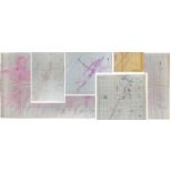

MIITARY MAPS AND DOCUMENTS SHOWING THE TOWNS/VILLAGES IN ASHDOD AND GAZA IN PALESTINE, PRINTED 5TH O
A group of five maps of Gaza and Ashdod region, showing all the towns, roads, rivers, and villages for military strategic purposes used by the Sau...
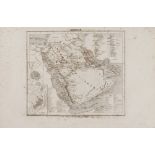
A RARE NON COLORED PRINTED FRENCH MAP OF THE ARABIC WORLD DURING THE OTTOMAN EMPIRE (ARABIA PENINSUL
Printed in black and white on thick paper. The continent showing the city/town names, such as Hejaz, Yemen, Hadramout, Najid, and the Arabian dese...
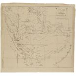
THREE RARE MAPS OF THE ARABIAN PENINSULA BY THE SURVEYOR ‘YEMENI’ BETWEEN 1850s TO 1860s, PRINTED BY
Military map of Basra State, signed by ‘Yemani’ 1850-1860 39 by 52 cm.Military map of Hijaz State, signed by ‘Yemani’ , 1850-1860 52 by 38.5 cm...
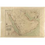
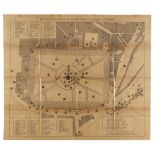
AN IMPORTANT DETAILED MILITARY OTTOMAN MAP OF THE ARABIAN PENINSULA, ESPECIALLY DIR’IYAH, DATED 1325
The map with five key functions 1) the road from Jeddah to Mecca and Taif 2) Mecca 3) Medina 4) Jeddah port 5) The city of Dir’iyah and its enviro...
FIVE PRINTED FOLDED MAPS OF MOSUL-LAKE VAN, MOSUL-ALEPPO AND MECCA FOR TOURISTIC PURPOSES, ISTANBUL
A group of 5 maps, 4 maps showing the ways from Mosul (a city in the north of Iraq) to lake Van (far east Turkey). The last map for Mecca (holy pl...

HAJJ GUIDE FOR PILGRIMS GOING TO MECCA AND MEDINA AND A BOOK BY MR. MOHAMMED PASHA SADIQ DATED 1313
Unique guidbook for pilgrims visiting Mecca and Medina showing the roads and the stops that they need to follow. Attached, a map of the road that ...
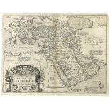
A VINTAGE ORIGINAL MAP OF THE OTTOMAN EMPIRE BORDERS INCLUDING THE ARABIA PENINSULA AND NORTH AFRICA
An engraved map in black and white. It is part of A. Ortelius’s atlas Teatrum Orbis Terarum, Antwerp. Describing the Ottoman empire during that pe...

A MILITARY MAP, USED DURING THE ARAB REVOLUTION IN HIJAZ, PRINTED BY THE ‘EGYPTIAN SURVEY AUTHORIT
The map has been planned by official staff working in the Egyptian Hajj Department and members of Alsharif Hussain bin Ali forces. Lawrence of Ara...

A LARGE PANORAMIC VIEW MAP SHOWING THE COASTS FROM BASRA ( SOUTH OF IRAQ ) TO QATAR DATED 1324 AH (1
An important 4 pages paper map in wide-scale showing the cities and the ports aligned by the west coast of the Arab Gulf from south of Iraq (Basra...

Map (1) A limited-edition blue-colored map regarding the developingprogram of the Ottoman empire’s railroad network, in French with some Ottoman a...
-
10 item(s)/page