Refine your search
Sale Section
Category
Filtered by:
- Sale Section
- List
- Grid
-
24 item(s)/page
A subscription to the Price Guide is required to view results for auctions ten days or older. Click here for more information
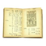

WW2 HOME FRONT ARP WARDEN'S PERSONAL NOTEBOOK, 1939-1945, a fascinating WWII ARP warden's personal notebook, covering gas training, detailed notes...
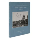
BOMB DAMAGE MAPS,
BOMB DAMAGE MAPS, 'The London County Council Bomb damage maps, 1939-1945', by Anne Saunders (ED), with an introduction by Robert Woolren, Topograp...
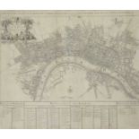
JOHN SENEX MAP OF LONDON,
JOHN SENEX MAP OF LONDON, 1720, copper Engraved New Map of London with partial hand colouring, 50 x 58cm, framed The map shows London as it was bu...
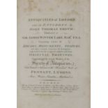
'ANTIQUITIES OF LONDON',
'ANTIQUITIES OF LONDON', J T Smith - Antiquities of London, 1791, (LONDON) - Antiquities of London and its Environs. L, Sewell, Cornhill, Faulder,...

1960s QUEEN MAGAZINE
1960s QUEEN MAGAZINE, 1960s, a collection 40 London society Queen magazines with many great photographers and models of the time including John Co...

1960s QUEEN MAGAZINE,
1960s QUEEN MAGAZINE, 1960s, a collection of 40 London society Queen magazines, with many great photographers and models of the time including Joh...
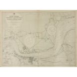
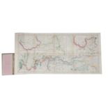
ADMIRALTY CHART OF THE RIVER THAMES, an early Admiralty chart of the River Thames, Broadness to Mucking Flats including Gravesend and Lower Hope R...
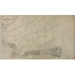
ADMIRALTY CHART OF THE RIVER THAMES, an early Admiralty chart of the River Thames Entrance, North Foreland to the Nore, from the latest Admiralty ...
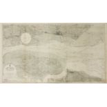
ADMIRALTY CHART OF THE RIVER THAMES, an early Admiralty chart of River Thames Sea Reach surveyed by The Port of London Authority to 1931, first pu...
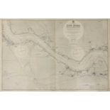
ADMIRALTY CHART OF THE RIVER THAMES, an early Admiralty chart of Erith to Broadness from surveys by the Port of London Authority to 1933, first pu...
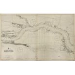
ADMIRALTY CHART OF THE RIVER THAMES, an early Admiralty chart of Woolwich to Erith from surveys by The Port of London Authority to 1931, first pub...
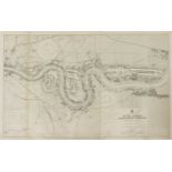
ADMIRALTY CHART OF THE RIVER THAMES, an early Admiralty chart of London Bridge to Woolwich including The Isle of Dogs (Canary Wharf) and Greenwich...
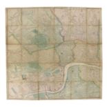
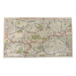
A LARGE LONDON MAP,
A LARGE LONDON MAP, 1860s, a folding map of London published by Weekly Dispatch, 139 Fleet Street, printed with hand colouring, 141 x 132cm
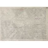
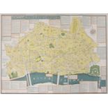
Buckingham Palace Map,
BUCKINGHAM PALACE MAP, a 1916 Land Registry Map of Buckingham Palace, Green Park, Belgravia, Mayfair, St James’s Park and St James and parts of We...
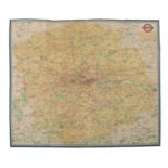
DUCKHAM'S MAP OF LONDON,
DUCKHAM'S MAP OF LONDON, 1950s/1960s, Duckham's Historical Map of the City of London, designed by L J Flux published by DUCKHAM OILS of West Wickh...
RIVER THAMES,
RIVER THAMES, 1- Bacon’s New Map of the River Thames, from its source to the sea. With descriptive notes. Being a guide for yachtsmen, oarsmen, an...
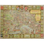
LONDON, THE BASTION OF LIBERTY,
LONDON, THE BASTION OF LIBERTY, designed by Kerry Lee in 1946, published by Pictorial Maps Limited, printed by Chromoworks Limited, 100.5 x 124.5c...
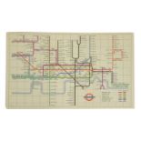
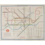
A LONDON UNDERGROUND MAP,
A LONDON UNDERGROUND MAP, 1957, HC Beck London Diagram of Lines Underground Map – LT Code 1156/2672D.1,000,000, 23 x 15cm
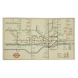
A LONDON UNDERGROUND MAP,
A LONDON UNDERGROUND MAP, 1972, London Underground Quad Royal Platform Map, June 1972 designed by Paul E. Garbutt – LT Code 873/2855m/3000 – print...
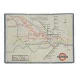
A LONDON UNDERGROUND MAP,
A LONDON UNDERGROUND MAP, 1947, HC Beck London Diagram of Lines Underground Map – LT Code 146.214G.250000 (2R) A rare post-WWII low circulation ma...
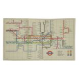
A LONDON UNDERGROUND MAP,
A LONDON UNDERGROUND MAP, 1960, HC Beck London Diagram of Lines Underground Map – LT Code 360/5952/500,000, 23 x 15cm This design of the London Un...
A LONDON UNDERGROUND MAP,
A LONDON UNDERGROUND MAP, 1933, a rare London Passenger Transport Board - Underground railways map of London 1933, designed by H C Beck, 2nd Editi...
A LONDON DISTRICT RAILWAY MAP,
A LONDON DISTRICT RAILWAY MAP, 'The District Railway Map of London' (c.1896-1898), 6th Edition, published by Sampson Low Marston and Company Limit...
A LONDON PASSENGER TRANSPORT BOARD MAP, 1934, 'ALL ROUTES - ROAD & RAIL', including buses, trams, underground and overground railways, printed to ...
-
24 item(s)/page