Refine your search
Filtered by:
- Category
- List
- Grid
-
37 item(s)/page
A subscription to the Price Guide is required to view results for auctions ten days or older. Click here for more information
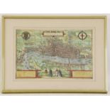

BRAUN (GEORG) AND FRANZ HOGENBERG: Londinum Feracissimi Angliae Regni Metropolis C1575. Hand-coloured engraved map, title cartouche with border of...
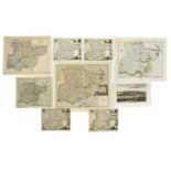
Two MAPS:
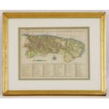
Two MAPS: South part of the principality of WALES, with Gloucestershire & part of Somersetshire. Hand coloured (370 x 520mm); mounted, framed and ...
![[BLAEU, Joan]:](https://portal-images.azureedge.net/auctions-2022/srswo10507/images/f1f72b51-c04d-47f1-bd77-aee700f10bbb.jpg?w=155&h=155)
[BLAEU, Joan]:
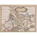
[BLAEU, Joan]: MAP of Somersetshire- Somerset: Tensis Comitatus. | Somersetshire. (1648), Hand coloured (510 x 400mm); mounted, framed and glazed;...
Stow & Strype:
Stow & Strype: MAP of the Parish of St. Mary Magdalene n Bermondsey. C1754, Hand coloured (315 x 390mm); mounted, framed and glazed; Plus: A Map o...
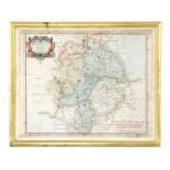
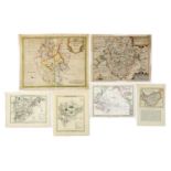
Bowen, Emanuel:
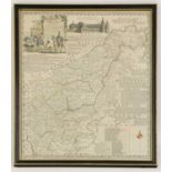
Bowen, Emanuel: An accurate map of Northamptonshire divided into it's hundreds, with vignette of Peterborough Cathedral. Hand coloured, mounted, f...
A map of Warwickshire
A map of Warwickshire, after Robert Morden, hand coloured, stuck down, (375 x 450mm), together with another, after John Speede, (425 x 550mm) (2)C...
London Maps:
London Maps: 1- Andrews's New and Accurate Map of the Country Thirty Miles Round London. Andrews, 1787. Hand-coloured, 670 x 620mm, dissected and ...
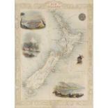
7 Original hand-coloured & mounted MAPS: TALLIS, J: Van Diemen's Island or Tasmania, (340 x 250mm); New Zealand, (350 x 260mm); Western Australia ...
Collection of 12 Original hand-coloured & mounted MAPS, including: Rapin- Plan de Barcelone, nd, c1750 (130 x 65mm); Wyld- Russia in Asia. c1819 (...
(Moll Herman): A map of the North Pole. c.1760, (200 x 265mm) and a later map of the Eastern Hemisphere. (240 x 308mm) (2) ...[more]
C35 loose MAPS OF ESSEX (18th. & 19th. Century), including: Harrison: View accurate & correct map of Essex, 1787 (Folio, hand coloured) with a tea...
ROAD MAPS: BOWEN:
ROAD MAPS: BOWEN: Britannia Depicta. A disbound incomplete volume with many road maps, some hand coloured; Plus c15 other hand coloured Road Maps....
C50 loose COUNTY MAPS (18th. & 19th. Century, many hand coloured), including: MORDEN: Bark shire; Bedfordshire (4 copies); Huntingdonshire; Buckin...
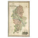
PHILLIPS, John, & W. F. HUTCHINGS: A Map of the County of Stafford Divided into Hundreds & Parishes, From an Accurate Survey, Made in the Years 18...
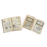
(ATLAS): RAPIN De Thoyras, Paul; Engraved by Basire: Atlas of Rapin’s History of England, No title page, Just 37 Double Page Maps, Plans & a view:...
MIDDLETON, J: CELESTIAL ATLAS, Containing Maps of All the Constellations Visible in Great Britain with Corresponding Blank Maps of the Stars, engr...

MANUSCRIPT-
MANUSCRIPT- Exercises in drawing: Plans & Maps, including 25 hand drawn maps of many foreign lands: India, Australia, British America, etc.Provena...

KING Ferdinand II of Aragon:
KING Ferdinand II of Aragon: Notarial Document in Latin of the possession of the town of Casamassina in Puglia (Southern Italy) in 1507, by King F...

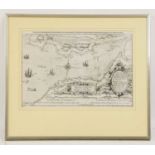
MOORE, Jonas:
MOORE, Jonas: A Mapp of Ye Great Levell of ye Fens extending into ye Countyes of Northampton, Norfolk, Suffolke, Lyncolne, Cambridge & Huntington ...

MAPS/Marshland-
MAPS/Marshland- Utting, J: 1- Plan of the survey & levels of the sewers, drains, bridges, tunnels & sluices in the parishes of the county of Marsh...

Ordnance Survey Maps:
Ordnance Survey Maps: Cameron & James: Ordnance survey of England & Wales- Rivers & their catchment basins. Southampton, 1867; (1400 x 1080mm), 16...


RAILWAY MAPS:
RAILWAY MAPS: Plan of the section of the Lynn & Ely Railway, with a branch to the harbour at Lynn & main line to Wisbech, survey under the directi...

CHARTS/
CHARTS/Rivers- Hand drawn & coloured Plan of Wisbech canal No.1; from a little beyond Gosmore lane Bridge to Outwell Sluice No.2; nd c18/19; Anoth...

Hanging MAPS:
Hanging MAPS: Runcton Holme. No date, hand coloured, 1200mm wide; with tears; Map of the town of Wisbech with new Walsoken, reduced from the board...

MAPS (Cambs.):
MAPS (Cambs.): Whittlesey Fen: An exact survey of these grounds herein specified.. Being parcel of the possession of W J Cropley of London, taken ...

Hanging MAP, Cambridge & Ely:
Hanging MAP, Cambridge & Ely: Map of the county of Cambridge & Isle of Ely, Surveyed by RG Baker, 1816, 17,18,19,20; republished in Earith, near S...

Bryant, A:
Bryant, A: Map of the county of NORFOLK from actual survey by A Bryant made in the years 1824, 25 & 26, respectfully dedicated to the nobility, cl...


MAPS/Methwold-
MAPS/Methwold- Browne (Surveyor): Plan of the Common Fields Warren & Common in the parish of Methwold, Norfolk, as divided by the act of parliamen...

MAPS/Norfolk-
MAPS/Norfolk- Hand-drawn map on vellum, coloured & with Shield: Some lands belonging to Capt. W. Hudson in the Parishes of Grimston & Bawsey, Norf...

MAPS/Norfolk:
MAPS/Norfolk: Map on vellum of Heacham, copied from the award map, J Browne, Norwich; (720 x 680mm). Hand coloured; little grubby; Copy of the pla...

Bryant, A:
Bryant, A: Map of the county of Lincoln from a survey made in the years 1825, 26 & 27. A Bryant, April 18, 1828. Published in two parts, North and...

Major COLBY:
Major COLBY: Ordnance survey map of Lincolnshire, in 8 parts: 1- Sleaford, Spalding & Newark on Trent; 2- Lincoln, Market Rasen & Horncastle; 3- H...

Map of the County of Lincoln,
Map of the County of Lincoln from an Actual Survey made in the Years 1827 & 1828. Greenwood & Co. Feb. 24, 1830. In three large folding linen back...

MAPS/Fen Drainage-
MAPS/Fen Drainage- Bedford level. April 1789. Folding, linen backed (780 x 580mm), with marbled paper to each end and the original marbled slipcas...
-
37 item(s)/page