Filtered by:
- Category,
- Creator / Brand
- List
- Grid
-
94 item(s)/page
A subscription to the Price Guide is required to view results for auctions ten days or older. Click here for more information
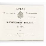

P.J. Mendel and H. Reding. Album voor de Aardrijkskunde. Atlas van het Koningrijk der Nederlanden en de Overzeesche Bezittingen. Atlas van het Kon...
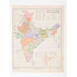
Railway Map of India
Major General Girish Chandra Agarwal, 1986. 13th ed. 117 x 91.5 cm.Occas. mild browning, very good condition. ...[more]

Collection of 20 railway maps
Ca. 20th cent. Incl. a.o.: 13 maps of the Nederlandse Spoorwegen and predecessors, 1916-1987; 1 North Eastern Railway and London, 1939; and 5 Deut...
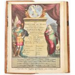
Le Théâtre de Bellone
Contenant 50 (= 48, complete) nouvelles cartes geographiques, des Païs Bas Espagnols, Provinces-Unies, haute et basse Allemagne, les Electorats & ...
and Belgium. 18th to 19th cent. 8vo and 4to. Collection of approx. 100 sm. maps w. some duplicates. General, provincial, and regional maps of the ...

18th and 19th cent. Sm. and large folios. Collection of approx. 60 general maps of the Netherlands w. some duplicates. Lithogr., steel and copper ...
Continens Marchionatus S. Rom. Impery, Bergozomanum, Comitatus Hoochstr. (...) Baroniam Bredanam (...). Amst., H. Hondius, ca. 1630. 47 x 55 cm. I...
Eleganter Distinctus (...). Amst., Petrus Schenck. ca. 1720. 60 x 49 cm. Large allegorical cartouche w. dedication Dno Harmanno de Wilde, chiliarc...
w. surroundings and Zaltbommel w. Bommelerwaard: (1) Accuratissima Ditionis Silvae-Ducensis Tabula. Amst., Henricus Hondius, ca. 1630. 42 x 54.5 c...
et Expugnata Armis Ord. Belg. Conf. Ab Illustrissimo Principe Mauritio. 1602. Amst., Joan Blaeu, 1649. 39 x 53 cm. Copper engr., title in cartouch...
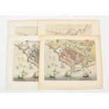
Six maps of Heusden: Heusden
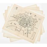
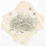
Plan in bird's eye view taken from Joan Blaeu's "Stedenboek". Amst., 1649. 42 x 53.5 cm. Cartouche w. title on plan, coats of arms and legenda, ve...
St. Geertruydenbergae confecta ab illustr. Principe Mauritio Nassovio (...) anno 1595 taken from Blaeu's "Stedenboek". Amst., 1649. 45 x 57 cm. Co...
(1) and (2) A plan of Helmont w. title in cartouche and a coat of arms together w. fortification plans of Ravestein w. coat of arms and Crevecoeur...
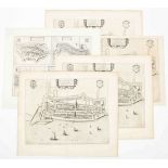
(1) Tabula Bergarum ad Zomam Stenbergae et novorum ibi operum. Amst., Joannes Janssonius, ca. 1650. 23 x 54 cm. Tear outside the map image.(2) Ber...
Verso Flissinga. Double folio plan from a Latin ed. of the "Stedenboek". Amsterdam, 1649. 42 x 52 cm. Col.(2) Joan Blaeu. Vlissingen, verso Vlissi...
Verso Middelburgh, double folio plan from a Dutch ed. of the "Stedenboek". Amst., 1649. 47 x 58 cm. Repaired tear and sm. hole outside the image.(...
amplissimis, consultissimis et spec. etc. 2 maps from the "Stedenboek". Amst., 1649. 1 Dutch and 1 Latin ed.(3) Joh. Janssonius. Plan from a Latin...
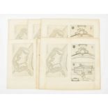
Six maps of Goes: Joan Blaeu. Goes
Verso Descr. Goesae, fortification plan from a Latin ed. of the "Stedenboek". Amst., 1649. 38 x 50.5 cm. Col.(2) Joan Blaeu. Verso Descr. Goesae. ...
Eight maps of Veere:Vere
Townplan. Guicciardini, ca. 1612. 23 x 30.5 cm. Col.(2) Vere. Guicciardini, nr. 64. Amst., J. Janssonius, 1648. 23 x 30.5 cm. (3) and (4) Veere. B...
Ten maps of Tholen: Tholen
Tolen. J. Blaeu. Double folio plan taken from a Dutch ed. of the "Stedenboek". Amst., 1649. 42 x 51 cm.(2) Tolen Tola. J. Blaeu. Double folio plan...
18 maps, incl. Zeeuws Vlaanderen
(1) Blaeu or De Wit. Double folio leaf w. plans of Hulst and Ostende and fortifications of 't Fort Mardyck and 't Sas van Gent. Ca. 1650-1700. 56 ...
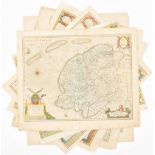
De Jode. Germaniae Inferioris
Galliae Belgicae dictae continentis invictissimi Hispaniarum Regis ditiones ac provincias (...) descriptio elaborata per Mathiam Zinck Noricum. An...
Amst., 1647. Fully col.(2) Seutter. Atlas Novus. Augsburg, ca. 1730. Fully col., dam. right bottom corner. (3-8) Blaeu. Tooneel der Steden van de ...
depuis sa Source jusques (...) tous les Estats et Souverainités qui sont dessus et aux environs. Amst. 44 x 58 cm. Pierre Mortier after Sanson, ou...
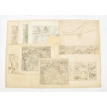
ende Belegheringhe van Schenkenschans, 1635-36, J. Blaeu. Amst., 1650. 47 x 57 cm. Detailed map of the siege of Schenkenschanz. The map shows the ...
50 x 73 cm. Double folio map on silk, glued on cardboard, of the border regions of Germany and the Netherlands between the Meuse and the Rhine, ou...
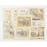
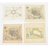
Five maps of Stavoren
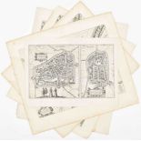
(1) and (2) 2 double folio town plans by J. Blaeu from the Dutch ed. of the "Stedenboek" or Tooneel der Steden. Amst., 1649. Cartouche w. title, c...
Five maps of Bolsward
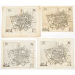
(1-4) 4 identical town plans from Bolswaert. 39.5 x 53 cm. W. title, coats of arms, cartouche w. dedication, and signed in the plate J. Blaeu. 1 L...
Four maps of Harlingen
(1-4) 4 identical town plans of Harlingen. 42 x 52 cm. W. coats of arms, title w. allegorical cartouche and legenda. 1 plan by Blaeu from a Latin ...
Five maps of Franeker
(1-4) Franikera. Franeker, 4 identical double folio town plans. 41.5 x 52.5 cm. All by J. Blaeu from his "Stedenboek". Amst., 1649. Title in alleg...
Three maps of Dokkum: Dockum
Plan. J. Blaeu taken from the "Stedenboek". Amst., 1649. 51 x 54 cm. Dutch ed. One brown ink spot at the Bredestraat, middle fold sl. browned. Amp...
Six maps of Leeuwarden: Leoverdia
Town plan by G. Leti. Amst., Willem De Jonge, 1690. 40 x 50 cm. Col. copper engr., sm. margins, bottom paper margin added.(2) The same, uncol. (3)...
(...). Leeuwarden, Hendrik Halma, ca. 1725. 33 x 43 cm. 1 col.(3-6) Nieuwe kaart van Friesland behoorende tot het Vaderlandsch Woordenboek. Amst.,...
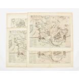
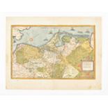
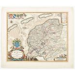
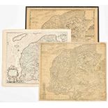
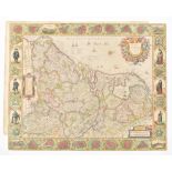
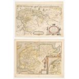
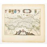
![P. Kaerius. Nieuwe beschrijvi[n]ge van oost en west vriesla[n]t](https://portal-images.azureedge.net/auctions-2022/zwigge10002/images/fcf7b952-3404-48da-86d0-af4c015444ae.jpg?w=155&h=155)
door Davidt Fabricio van Esentz soe wel voor water als te lande neerstelijck beschreven. Nova descriptio orientalis et occidentalis Frisiae (...)....
Autoribus Bernhardo Schotano a Sterringa. Suffrido Atonis Haacma et Sixto gravio. Amst., Jacobus van Meurs, ca. 1665. 42 x 52 cm. Contemp. col. co...
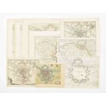
Three maps: Dominii Frisiae Tabula,
inter Flevum et Lavicam, Auctore B. Schotano a Sterringa. Amst., Nicolai Visscher, ca. 1700. 48 x 57 cm. Copper engr. map taken from a Visscher At...
Auctoribus Adriano Metio et Gerardo Freitag. Amst., H. Hondius and/or Johannes Janssonius, 1630-1650. Engr. by E.S. Hamers-veldt et E. Rogers, sig...
18th to 20th cent. (1-4) Maps by B. Schotanus a Sterringa. Leeuwarden, F. Halma, 1718. Incl. 2 copper engr. w. Lemsterland, Baarderadeel, Aengwerd...

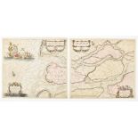
Paskaarte van de kuste
van Holland en Vriesland. Groeninger, Emder en Reydingerland, Holstyn, Ditmarsche en't Eydersted. Amst., Joannes van Kuelen (=van Keulen), ca. 168...
Schakels met het verleden. De geschiedenis van de kartografie van Suriname 1500 - 1971/ Eslabones con el pasado. La historia de la cartografia de ...
Nine maps
17th to 19th cent. (1) Regional map of Amsterdam [Amstelredam] and surroundings. 17th cent. copy of a part of Joost Jansz Beeldsnijders map: Caert...
deel der Weereld (...) Scheepstogten der Nederlanderen naar Westindie. Amst., Tirion, 1754. 34 x 36 cm. Handcol., fold. as issued.(2) Nieuwe Kaart...
van het Oostelykse deel der Weereld (...) Scheepstogten der Nederlanderen naar Oostindie. Amst., Tirion, 1753. 32 x 36.5 cm. Handcol., fold. as is...
Accuratissima Tabula. Amst., 1631. 48 x 60 cm. Col., fold. as publ., ill. borders, upper and lower sides w. towns and views in ovals, left and rig...
Tot aen 't eylandt Roosenburgh alsmede 't inkoomen van't Goereesche gat (...).(2) Pascaert Van't eylandt Roosenburg door de Oude en Nieuwe Maes to...
Provinciarum Typus. Arnhem, J. Janssonius, 1614. 25 x 32 cm. Verso German text. Map from Emanuel van Meteren's Eigentliche und volkomene Historisc...
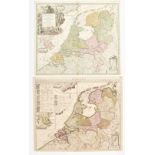
communi nomine vulgo Hollandia nuncupata Continens Statum potentissimae Batavorum Reipublicae seu Provincias VII Foederatas. Nuernberg, J.B. Homan...
Comitatus Drentiae D.D. Statoribus Eorumq (...) Reflore scentis Provinciae et Westerwoldiae Domini (...) [Auct.] Cornelis Pynacker. Amst., Henricu...
Two maps: Frisia Occidentalis
Author Sibrandus Leovardiensis. Antwerp, Abraham Ortelius, 1579. 36.5 x 50.5 cm. Col., large cartouche w. inset Antiquae Frisiae (19 x 15 cm), ver...
Six maps: Groninga Dominium
Auctore Bartholdo Wicheringe. Amst., Willem Blaeu, ca. 1650. German ed. 38 x 49 cm. 2 large cartouches w. coat of arms, title and scales.(2) The s...
Tabulae Dominii Groeningae
Quae et complectitur maximam partem Drentiae emendata a F. de Wit. Amst., ca. 1690. 47 x 55 cm. Outline and cartouche col., w. coat of arms, scale...
One map of Braun and Hogenberg
Trajectum ad Mosam Cologne. Ca. 1600. 35.5 x 41.5 cm. Verso Latin text, faded col., some modern col., printer's mistake next to middle fold. Sl. b...
Novo Descriptio. Amst., Pieter van de Keere, 1616. 38 x 49 cm. Col., 2 cartouches w. title, coat of arms, view of Limborgh town in Belgium, scales...
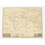
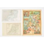
Planisphère illustré
présentant la description géographique des parties connues de la Terre (...) les colonies des diverses nations (...) dressé par Vuillemin. Gravé p...
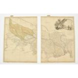
with Part of Agra and Delhi exhibiting the Course of the Ganges from Hurdwar to the Sea. Surveyed by James Rennell. London, for William Faden, 178...
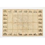
de la ville de Bruxelles et ses environs. G. Jacowick, 1812. 30 segments w. town plan, coat of arms and street list.(2) W.H. Loth. Kaart van Guian...
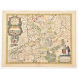
38.5 x 53 cm. Map of Gelderland, the area around Nijmegen between Schenkenschans and Loevenstein, after J. Blaeu in a later [ca. 1680] ed. Col. w....
Four maps: Ducatus Geldriae
Batavae et Hispanicae in Tetrarchias Noviomagi, Arnhemii, Ruremondae & Zutphaniae Comitatus. Amst., Carolus Allard, 1705. 60 x 50 cm. Large allego...
Sive Velavia, after F. de Wit. Amst., Covens and Mortier, ca. 1750. 47 x 57 cm. 2 cartouches w. title, putti, scales and coat of arms. Faded col.,...
21 maps: Ducatus Gelriae
pars quarta quae est Arnhemiensis sive Velavia. Amst., Johannes Janssonius, ca. 1650. 39 x 52 cm. 3 cartouches w. title, coat of arms, legend and ...
-
94 item(s)/page