No Image Lot 17 various lot with an antique English box with inlay of mother of pearl and a British baton || Lot van 17various lot with an antique English box with inlay of mother of pearl and a British baton || Lot van DVC various lot with an antique English box with inlay of mother of pearl and a British baton || Lot van een antiek Engels kistje ingelegd met parelmo... Add to watchlist Live
No Image Lot 19 Studio of Frank Llyod Wright blueprint 19Studio of Frank Llyod Wright blueprint Morgan Auctions Measures approx. 36 x 22 inches, foxing and yelling on edges Add to watchlist Live
No Image Lot 36 Middle East.- Fraser (James) The History of Nadir Shah, formerly called Thamas Kuli Khan, second ... 36Middle East.- Fraser (James) The History of Nadir Shah, formerly called Thamas Kuli Khan, second ... Forum Auctions Middle East.- Fraser (James) The History of Nadir Shah, formerly called Thamas Kuli Khan, second edition, engraved frontispiece, folding engraved ... Add to watchlist Live
No Image Lot 57 Hungary.- Speed (John) The Mape of Hungari..., engraved map, 1626 [but c.1676] 57Hungary.- Speed (John) The Mape of Hungari..., engraved map, 1626 [but c.1676] Forum Auctions Hungary.- Speed (John) The Mape of Hungari..., carte-a-figure map, eight costumed figures to the vertical margins, four oval vignettes of principa... Add to watchlist Live
No Image Lot 66 Spain.- Laborde (Alexandre de) A View of Spain, 5 vol., 1809; and 2 others (7) 66Spain.- Laborde (Alexandre de) A View of Spain, 5 vol., 1809; and 2 others (7) Forum Auctions Spain.- Laborde (Alexandre de) A View of Spain, 5 vol., 29 engraved maps, some folding, a few vol. with book labels, some leaves spotted or browne... Add to watchlist Live
No Image Lot 67 World.- Bowdler (Thomas) Letters Written in Holland..., first edition, Printed for the Benefit of... 67World.- Bowdler (Thomas) Letters Written in Holland..., first edition, Printed for the Benefit of... Forum Auctions World.- Bowdler (Thomas) Letters Written in Holland, in the Months of September and October, 1787..., first edition, 2 folding engraved maps, titl... Add to watchlist Live
No Image Lot 68 World.- Levasseur (V.) Atlas National Illustre des 86 Departements et des Possessions de la Franc... 68World.- Levasseur (V.) Atlas National Illustre des 86 Departements et des Possessions de la Franc... Forum Auctions World.- Levasseur (Victor) Atlas National Illustre des 86 Departements et des Possessions de la France Divise par Arrondissements, Cantons et Comm... Add to watchlist Live
No Image Lot 68 Erdglobus. Herausgegeben von Kartogr. 68Erdglobus. Herausgegeben von Kartogr. Auktionsgalerie am Hofgarten Hannelore Rothenbücher e.K. Erdglobus.Herausgegeben von Kartogr. Institut der Verlagshandlung von Dietrich Reimer. (Andrews u. Steiner) 1943, Masstab 1:38.000 000. Holzbodenp... Add to watchlist Live
No Image Lot 70 Britain.- Camden (William) Viri Clarissimi Britannia, sive florentiss Regnorum Angliæ, Scotiæ, Hi... 70Britain.- Camden (William) Viri Clarissimi Britannia, sive florentiss Regnorum Angliæ, Scotiæ, Hi... Forum Auctions Britain.- Camden (William) Viri Clarissimi Britannia, sive florentiss Regnorum Angliæ, Scotiæ, Hiberniæ ..., title with woodcut device, 18 folding... Add to watchlist Live
No Image Lot 71 Britain.- Cary (John) Cary's New and Correct English Atlas, 1793. 71Britain.- Cary (John) Cary's New and Correct English Atlas, 1793. Forum Auctions Britain.- Cary (John) Cary's New and Correct English Atlas, engraved title, engraved dedication, 47 engraved maps hand-coloured in outline, tissue... Add to watchlist Live
No Image Lot 74 Britain.- Railways Handkerchief (1850s) The Railways in Great Britain, Also the Line of Navigatio... 74Britain.- Railways Handkerchief (1850s) The Railways in Great Britain, Also the Line of Navigatio... Forum Auctions Britain.- Railways Handkerchief Map (circa 1850s) The Railways in Great Britain, Also the Line of Navigation From the Principal Sea Ports to Both ... Add to watchlist Live
No Image Lot 75 England.- Fuller (Thomas) The History of the Worthies of England, first edition, Printed by J.G.W... 75England.- Fuller (Thomas) The History of the Worthies of England, first edition, Printed by J.G.W... Forum Auctions England.- Fuller (Thomas) The History of the Worthies of England, first edition, engraved portrait frontispiece, 12pp. 18th century index at end, ... Add to watchlist Live
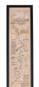
No Image Lot 78 Ireland.- Taylor (Alexander) A New Map of Ireland..., [c.1790s]. 78Ireland.- Taylor (Alexander) A New Map of Ireland..., [c.1790s]. Forum Auctions Ireland.- Taylor (Alexander) A New Map of Ireland..., engraved map with original hand-colouring, sheet 738 x 623 mm., dissected and mounted on lin... Add to watchlist Live
No Image Lot 81 Kent.- Speed (John) Kent with her Cities and Earles described and observed, engraved map, 1676 81Kent.- Speed (John) Kent with her Cities and Earles described and observed, engraved map, 1676 Forum Auctions Kent.- Speed (John) Kent with her Cities and Earles described and observed, county map with inset plans of Rochester and Canterbury, engraving wit... Add to watchlist Live
No Image Lot 82 Kent.- Symonson (Philip) A New Description of Kent...., the tractes of Ryuers, Rylles and creeks ... 82Kent.- Symonson (Philip) A New Description of Kent...., the tractes of Ryuers, Rylles and creeks ... Forum Auctions Kent.- Symonson (Philip) A New Description of Kent...., the tractes of Ryuers, Rylles and creeks with the trendinge of the Sea-Shore be more natur... Add to watchlist Live
No Image Lot 83 London.- Ogilby (John) The Road from London to Aberistwith...; The Continuation of ye Road from L... 83London.- Ogilby (John) The Road from London to Aberistwith...; The Continuation of ye Road from L... Forum Auctions London.- Ogilby (John) The Road from London to Aberistwith...; The Continuation of ye Road from London to Aberistwith, Plate ye Second...; The Con... Add to watchlist Live
No Image Lot 84 River Thames.- Pine (John) Thamesis Descriptio Anno 1588, after Robert Adams (c.1530-1595), engra... 84River Thames.- Pine (John) Thamesis Descriptio Anno 1588, after Robert Adams (c.1530-1595), engra... Forum Auctions River Thames.- Pine (John) Thamesis Descriptio Anno 1588, after Robert Adams (c.1530-1595), engraving, from a copy drawn by Mr. Joseph Ames, 8 Apr... Add to watchlist Live
No Image Lot 91 Slim Aarons Print - Jhelum River 1961 - 91Slim Aarons Print - Jhelum River 1961 - Morgan Auctions Photolitho,Measures 40 x 30 inches Add to watchlist Live
No Image Lot 93 THE OARSMANS AND ANGLERS MAP OF THE THAMES 93THE OARSMANS AND ANGLERS MAP OF THE THAMES Dreweatts 1759 THE OARSMANS AND ANGLERS MAP OF THE THAMES Mounted, framed and glazed 175 x 14cm overall Add to watchlist Live
No Image Lot 97 Howitt (Samuel) [A New Work of Animals, Principally Designed from the Fables of Æsop, Gay, and Ph... 97Howitt (Samuel) [A New Work of Animals, Principally Designed from the Fables of Æsop, Gay, and Ph... Forum Auctions Howitt (Samuel) [A New Work of Animals, Principally Designed from the Fables of Æsop, Gay, and Phædrus], lacking title, but with manuscript index,... Add to watchlist Live
No Image Lot 151 Nationalsozialismus - 151Nationalsozialismus - Nosbüsch & Stucke GmbH Auktionen Berlin Nationalsozialismus - Konzentrationslager - - Plan obozu Koncentracyjnego "Gusen" Austrii kolo Lincu. 1:2880. Lichtdruck. Gezeichnet v. M. Kurasni... Add to watchlist Live
No Image Lot 159 Royal Justiciar to Henry III.- Basset (Philip) Copy of a charter, granted in 1268 by Sir Henry Lo... 159Royal Justiciar to Henry III.- Basset (Philip) Copy of a charter, granted in 1268 by Sir Henry Lo... Forum Auctions Royal Justiciar to Henry III.- Basset (Philip, justiciar and royalist nobleman, d. 1271) Copy of a charter, granted in 1268 by Sir Henry Longchamp... Add to watchlist Live
No Image Lot 189 Fast against the French enemy.- Queen Anne By the Queen, a Proclamation, for a General Fast...for... 189Fast against the French enemy.- Queen Anne By the Queen, a Proclamation, for a General Fast...for... Forum Auctions Fast against the French enemy.- Queen Anne. By the Queen, a Proclamation, for a General Fast...for disappointing the boundless ambition of France,... Add to watchlist Live
No Image Lot 198 Frank Llyod Wright ‘The Winslow House’ blueprint 198Frank Llyod Wright ‘The Winslow House’ blueprint Morgan Auctions Measures approx. 36 x 22 inches, foxing and yelling on edges Add to watchlist Live
No Image Lot 210 Johnson (Samuel) A Dictionary of the English Language, 2 vol., fifth edition, for W. Strahan, et ... 210Johnson (Samuel) A Dictionary of the English Language, 2 vol., fifth edition, for W. Strahan, et ... Forum Auctions Johnson (Samuel) A Dictionary of the English Language, 2 vol., fifth edition, titles in red and black, vol. 1 lacking all after 12Z2, initial leav... Add to watchlist Live
No Image Lot 211 Alter kolorierter Kupferstich mit Darstellung des Bistums Hildesheim nebst Umland von Johann Jansso 211Alter kolorierter Kupferstich mit Darstellung des Bistums Hildesheim nebst Umland von Johann Jansso Göttinger Auktionshaus Alter kolorierter Kupferstich mit Darstellung des Bistums Hildesheim nebst Umland von Johann Janssonius (1588 - 1664) aus dem Jahr 1647; Doppelsei... Add to watchlist Live
No Image Lot 212 Seltener, quadratischer Kupferstich des Stadtkerns von Göttingen; Darstellung des Stadtkerns mit Wa 212Seltener, quadratischer Kupferstich des Stadtkerns von Göttingen; Darstellung des Stadtkerns mit Wa Göttinger Auktionshaus Seltener, quadratischer Kupferstich des Stadtkerns von Göttingen; Darstellung des Stadtkerns mit Wall, wohl im 17. Jhd.; war mehrfach gefaltet; Ra... Add to watchlist Live
No Image Lot 213 Alter Merian Kupferstich von 1654 mit Darstellung der "Stad und Festung Nienburg - an der Weser"; h 213Alter Merian Kupferstich von 1654 mit Darstellung der "Stad und Festung Nienburg - an der Weser"; h Göttinger Auktionshaus Alter Merian Kupferstich von 1654 mit Darstellung der "Stad und Festung Nienburg - an der Weser"; hinter Passepartout gerahmt; Maße ca.: Bild: 21x... Add to watchlist Live
No Image Lot 228 Maps of France 1881 "Le Ministre De La Guerre", original case. 228Maps of France 1881 "Le Ministre De La Guerre", original case. Costa Blanca Auctions Maps of France 1881 "Le Ministre De La Guerre", original case. Add to watchlist Live
No Image Lot 272 Juvenilia.- A Present for A Little Girl, 1820; bound with 3 others, William Darton. 272Juvenilia.- A Present for A Little Girl, 1820; bound with 3 others, William Darton. Forum Auctions Juvenilia.- A Present for A Little Girl, engraved hand-coloured vignette on title, 27 brightly hand-coloured wood-engraved illustrations (3 full-p... Add to watchlist Live
No Image Lot 273 Albert Einstein Photo Print 273Albert Einstein Photo Print Morgan Auctions Albert Einstein, born on March 14, 1879, in Ulm, in the Kingdom of Württemberg in the German Empire, was one of the most influential scientists o... Add to watchlist Live
No Image Lot 280 Game.- Wallis (John) Wallis's New Game of Universal History and Chronology, engraving with hand-c... 280Game.- Wallis (John) Wallis's New Game of Universal History and Chronology, engraving with hand-c... Forum Auctions Game.- Wallis (John) Wallis's New Game of Universal History and Chronology, spiral track with 137 portraits and scenes around a portrait of the Pr... Add to watchlist Live
No Image Lot 467 Jan VAN CAMPENHOUT (1907-1972) 'City view by Night'. (W:60 x H:70 cm) 467Jan VAN CAMPENHOUT (1907-1972) 'City view by Night'. (W:60 x H:70 cm) Flanders Auctions Jan VAN CAMPENHOUT (1907-1972) 'City view by Night'Dimensions: (W:60 x H:70 cm) Add to watchlist Live
No Image Lot 485 Asien - Indonesien - - 485Asien - Indonesien - - Nosbüsch & Stucke GmbH Auktionen Berlin Asien - Indonesien - - Molluken. "Moluccae Insulae celeberrimae". Mit altem Grenz- und Flächenkolorit, Kupferstichkarte, G. Blaeu in Amsterdam, um... Add to watchlist Live
No Image Lot 494 Australien und Ozeanien - - Sotzmann, 494Australien und Ozeanien - - Sotzmann, Nosbüsch & Stucke GmbH Auktionen Berlin Australien und Ozeanien - - Sotzmann, Daniel Friedrich. Karte des Grossen Oceans gewöhnlich Das Süd Meer genannt, nebst allen neuen Entdeckungen i... Add to watchlist Live
No Image Lot 500 Josef Albers - Colored Homage Print (Gemini G.E.L.) 500Josef Albers - Colored Homage Print (Gemini G.E.L.) Morgan Auctions JOSEF ALBERS (1888-1976) Homage to the square Colored print on paper Publisher: Gemini G.E.L., Los Angeles, California, c.1966 Measures 7.50 X 7.... Add to watchlist Live
No Image Lot 511 Deutschland - Berlin - - Britz, N. 511Deutschland - Berlin - - Britz, N. Nosbüsch & Stucke GmbH Auktionen Berlin Deutschland - Berlin - - Britz, N. Plan vom Dorf und Schloss zu Glienicke bei Potsdam. Manuskriptkarte von N. Britz, Berlin, um 1875. Blattgröße: ... Add to watchlist Live
No Image Lot 519 Deutschland - München - - Hollar, 519Deutschland - München - - Hollar, Nosbüsch & Stucke GmbH Auktionen Berlin Deutschland - München - - Hollar, Wenzel. Monachium avilica sedes Ducum Bavariae. Gesamtansicht aus der Vogelschau. Kupferstich von WH (Wenzel Hol... Add to watchlist Live
No Image Lot 545 6 bottles of "Château Coufran" dd 1988 in its closed case || 6 flessen "Château Coufran" (Médoc) van 5456 bottles of "Château Coufran" dd 1988 in its closed case || 6 flessen "Château Coufran" (Médoc) van DVC 6 bottles of "Château Coufran" dd 1988 in its closed case || 6 flessen "Château Coufran" (Médoc) van 1988 in gesloten kist Add to watchlist Live
No Image Lot 661 Disneyland Matterhorn Bobsled Poster backed on linen 661Disneyland Matterhorn Bobsled Poster backed on linen Morgan Auctions Poster titled "Matterhorn Bobsled" 54" x 36" approximate sizeSome wear, backed on linen, some staining/creases, tears, etc. Add to watchlist Live
No Image Lot 691 Himmelsglobus von 691Himmelsglobus von Nosbüsch & Stucke GmbH Auktionen Berlin Himmelsglobus von Carl Rohrbach. Berlin, um 1896, bezeichnet "Himmelsglobus von Dr. Carl Rohrbach, D. Reimer Berlin (Hoefer&Vohsen)", der Globus a... Add to watchlist Live
No Image Lot 693 Seltener 693Seltener Nosbüsch & Stucke GmbH Auktionen Berlin Seltener Mondglobus von Paul Räth. Leipzig, 1963, bezeichnet mit "Räths Mondglobus, Durchmesser 33 cm, Maßstab 1:10400000, Die Namen der Formation... Add to watchlist Live
No Image Lot 694 Himmelsglobus von 694Himmelsglobus von Nosbüsch & Stucke GmbH Auktionen Berlin Himmelsglobus von Robert Henseling. Berlin, ca. 1920, bezeichnet "Dietrich Reimers Himmelsglobus, bearbeitet von Robert Henseling", der Globus als... Add to watchlist Live
No Image Lot 696 Induktions- oder 696Induktions- oder Nosbüsch & Stucke GmbH Auktionen Berlin Induktions- oder Schieferglobus. Deutschland, um 1920, ohne Herstellerbezeichnung, der Globus als mit Gips überzogene Pappmaché-Kugel, die Kontine... Add to watchlist Live
No Image Lot 697 Seltenes Lunarium 697Seltenes Lunarium Nosbüsch & Stucke GmbH Auktionen Berlin Seltenes Lunarium von Ernst Schotte. Berlin, um 1877, der Globus bezeichnet "Die Erdkugel nach den neuesten u. besten Quellen bearbeitet, Berlin E... Add to watchlist Live
No Image Lot 698 Mondglobus Paul 698Mondglobus Paul Nosbüsch & Stucke GmbH Auktionen Berlin Mondglobus Paul Räth. Leipzig, 1976, "Räths Erdmondglobus", das Kartenbild entworfen vom Kartographen Hellmuth Wolf im VEB Räthgloben-Verlag Leipz... Add to watchlist Live
No Image Lot 699 Schöner 699Schöner Nosbüsch & Stucke GmbH Auktionen Berlin Schöner Himmelsglobus mit figürlichen Sternbildern. Deutschland, um 1915, nicht bezeichnet, der Globus als Pappmaché-Kugel mit 12 farblithographie... Add to watchlist Live
No Image Lot 700 Erdglobus von 700Erdglobus von Nosbüsch & Stucke GmbH Auktionen Berlin Erdglobus von Wagner & Debes. Leipzig, um 1918, bezeichnet "Erd-Globus, von 96 cm Umfang, neu bearbeitet von Dr. H. Fischer, Leipzig, Wagner & Deb... Add to watchlist Live
No Image Lot 701 Erdglobus mit 701Erdglobus mit Nosbüsch & Stucke GmbH Auktionen Berlin Erdglobus mit Atlas-Figur vom Columbus-Verlag. Berlin, um 1925, bezeichnet "Schüler-Globus, Columbus-Verlag G.M.B.H. Berlin-Lichterfelde", der Glo... Add to watchlist Live
No Image Lot 702 Seltener Marine 702Seltener Marine Nosbüsch & Stucke GmbH Auktionen Berlin Seltener Marine Himmelsglobus aus Kapitänsnachlass. London, 1920, bezeichnet "The Husun Star Globe, H. Hughes & Son LTD, London, 1920", der Globus... Add to watchlist Live
No Image Lot 703 Barrow - General Chart Pekin 703Barrow - General Chart Pekin Auktionshaus Schramm Asien.- Barrow, J. A general chart, on Mercator's Projection, to shew the track of the Lion and Hindostan from England to the Gulph of Pekin in Ch... Add to watchlist Live
No Image Lot 703 Erdglobus nach 703Erdglobus nach Nosbüsch & Stucke GmbH Auktionen Berlin Erdglobus nach Georg Christoph Eimmart. Nürnberg, 1705, Faksimile Christian Nebehay, Wien 1958, bezeichnet "L.F., Cum Geographica Orbis, Terrarum ... Add to watchlist Live
No Image Lot 704 Mejer - 6 kolor. Kupferstichkarten 704Mejer - 6 kolor. Kupferstichkarten Auktionshaus Schramm Danckwerth.- 6 kolorierte Kupferstichkarten von J. Mejer aus Danckwerth, Newe Landesbeschreibung, Husum, 1652 bzw. Amsterdam, Blaew, 1662. Je ca. ... Add to watchlist Live
No Image Lot 705 Danckwerth/Mejer - Ca. 100 Karten 705Danckwerth/Mejer - Ca. 100 Karten Auktionshaus Schramm Danckwerth.- Konvolut von ca. 100 Kupferstichkarten (mit zahlreichen Dubletten) von J. Mejer aus Danckwerth, Newe Landesbeschreibung, Husum, 1652.... Add to watchlist Live
No Image Lot 706 Braun-Hogenberg - Eckernförde 706Braun-Hogenberg - Eckernförde Auktionshaus Schramm Eckernförde.- Ekelenforda antiquum Holsatiae ad Oceanum peninsulare oppidum. Kolor. Kupferstich von Braun u. Hogenberg, um 1590. 35 x 47 cm. Gerah... Add to watchlist Live
No Image Lot 709 Mejer - Sudertheill Gottorf 709Mejer - Sudertheill Gottorf Auktionshaus Schramm Gottorf.- Sudertheill des Amptes Gottorf. Kolor. Kupferstich von J. Mejer aus Danckwerth, 1652. 40 x 60 cm. Gerahmt.Das Gebiet nördlich der Eider,... Add to watchlist Live
No Image Lot 710 Seltener großer 710Seltener großer Nosbüsch & Stucke GmbH Auktionen Berlin Seltener großer Reliefglobus. Um 1950, nicht bezeichnet, der Globus aus Kunststoff, das Relief überhöht, das physikalische Kartenbild von Hand far... Add to watchlist Live
No Image Lot 711 Geographie-Puzzle. Frankreich, um 1860, Atlas Géographique, drei Karten von Europa, Frankreich und 711Geographie-Puzzle. Frankreich, um 1860, Atlas Géographique, drei Karten von Europa, Frankreich und Nosbüsch & Stucke GmbH Auktionen Berlin Geographie-Puzzle. Frankreich, um 1860, Atlas Géographique, drei Karten von Europa, Frankreich und Holland, herausgegeben von A. Logerot, Éditeur,... Add to watchlist Live
No Image Lot 713 Großer Erdglobus 713Großer Erdglobus Nosbüsch & Stucke GmbH Auktionen Berlin Großer Erdglobus von Ludwig Julius Heymann. Leipzig, um 1909, bezeichnet "Erd-Globus, 114 cm Umfang, Durchgesehen von Dr. Henry Lange, Leipzig, Lu... Add to watchlist Live
No Image Lot 715 Erdglobus für den 715Erdglobus für den Nosbüsch & Stucke GmbH Auktionen Berlin Erdglobus für den Beamten-Wirtschaftsbund. Berlin, um 1924, bezeichnet "Erdglobus der deutschen Beamten-Buchhandlung, Buchvertrieb des Beamtenschr... Add to watchlist Live


![Hungary.- Speed (John) The Mape of Hungari..., engraved map, 1626 [but c.1676]](https://portal-images.azureedge.net/auctions-2024/forum-10418/images/5bef1aa6-8f11-4f28-9b94-b15400e43335.jpg?h=175)


![Ireland.- Taylor (Alexander) A New Map of Ireland..., [c.1790s].](https://portal-images.azureedge.net/auctions-2024/forum-10418/images/ec86e9e5-e7a2-4639-ae48-b15400e481d6.jpg?h=175)