


A large vintage 1950s (1959) sales promotion wall hanging map of the British Isles. Scale 1:633,600 or 10 miles per inch. Measures approx 150x170c...
Collectables Auctions
Discover and bid on an impressive mix of collectibles for sale in live and timed online auctions at LOT-TISSIMO.
Popular categories
Antique & Vintage Maps
Music Instruments & Memorabilia
Bank Notes
Sports Memorabilia & Equipment
Stamps
Writing Instruments
Cameras & Photography Equipment
Entertainment Memorabilia
Religious Items & Folk Art
Antique Scientific Instruments
Antique Arms, Armour & Militaria
Vintage Wine & Spirits
Taxidermy
Featured auctions
Upcoming auctions


4 item(s)
Filtered by:
- Lots with images only,
- Category,
- Auction Type
- List
- Grid
-
4 item(s)/page
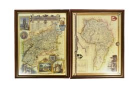
Two 20th Century reproduction maps of South-West interest, featuring a map of 'Somersetshire', dated '1836', and a map of 'Gloucestershire'. Both ...

A collection of seven 20th century Conic Projection maps together with another. The lot to include: the map of Iran (Persia) scale 1:4,000,000 pla...

Saxton, Christopher (c.1540-c.1610) & William Hole (d. 1624) - A 17th century etched & hand coloured map of Oxfordshire. The map reading: Oxoniens...