Verfeinern Sie Ihre Suche
Auktionshaus-Kategorie
Kategorie
Sortieren nach:
- Nur Massenlose anzeigen,
- Kategorie
- Liste
- Galerie
-
37 Los(e)/Seite
Ein Abonnement der Preisliste ist notwendig um Ergebnisse, von Auktionen die vor einem längeren Zeitraum als 10 Tagen stattgefunden haben, ansehen zu können. Klicken Sie hier für mehr Informationen
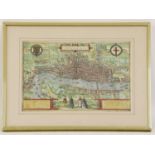

BRAUN (GEORG) AND FRANZ HOGENBERG: Londinum Feracissimi Angliae Regni Metropolis C1575. Hand-coloured engraved map, title cartouche with border of...
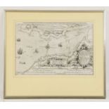
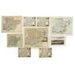
Two MAPS:
Two MAPS: South part of the principality of WALES, with Gloucestershire & part of Somersetshire. Hand coloured (370 x 520mm); mounted, framed and ...
![[BLAEU, Joan]:](https://portal-images.azureedge.net/auctions-2022/srswo10507/images/f1f72b51-c04d-47f1-bd77-aee700f10bbb.jpg?w=155&h=155)
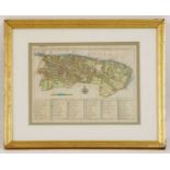
[BLAEU, Joan]:
[BLAEU, Joan]: MAP of Somersetshire- Somerset: Tensis Comitatus. | Somersetshire. (1648), Hand coloured (510 x 400mm); mounted, framed and glazed;...
Stow & Strype:
Stow & Strype: MAP of the Parish of St. Mary Magdalene n Bermondsey. C1754, Hand coloured (315 x 390mm); mounted, framed and glazed; Plus: A Map o...
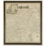
Bowen, Emanuel:
Bowen, Emanuel: An accurate map of Northamptonshire divided into it's hundreds, with vignette of Peterborough Cathedral. Hand coloured, mounted, f...
A map of Warwickshire
A map of Warwickshire, after Robert Morden, hand coloured, stuck down, (375 x 450mm), together with another, after John Speede, (425 x 550mm) (2)C...
London Maps:
London Maps: 1- Andrews's New and Accurate Map of the Country Thirty Miles Round London. Andrews, 1787. Hand-coloured, 670 x 620mm, dissected and ...
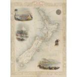
7 Original hand-coloured & mounted MAPS: TALLIS, J: Van Diemen's Island or Tasmania, (340 x 250mm); New Zealand, (350 x 260mm); Western Australia ...
Collection of 12 Original hand-coloured & mounted MAPS, including: Rapin- Plan de Barcelone, nd, c1750 (130 x 65mm); Wyld- Russia in Asia. c1819 (...
(Moll Herman): A map of the North Pole. c.1760, (200 x 265mm) and a later map of the Eastern Hemisphere. (240 x 308mm) (2) ...[more]
C35 loose MAPS OF ESSEX (18th. & 19th. Century), including: Harrison: View accurate & correct map of Essex, 1787 (Folio, hand coloured) with a tea...
ROAD MAPS: BOWEN:
ROAD MAPS: BOWEN: Britannia Depicta. A disbound incomplete volume with many road maps, some hand coloured; Plus c15 other hand coloured Road Maps....
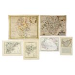
C50 loose COUNTY MAPS (18th. & 19th. Century, many hand coloured), including: MORDEN: Bark shire; Bedfordshire (4 copies); Huntingdonshire; Buckin...
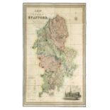
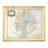
PHILLIPS, John, & W. F. HUTCHINGS: A Map of the County of Stafford Divided into Hundreds & Parishes, From an Accurate Survey, Made in the Years 18...
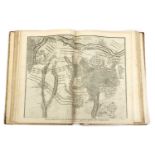
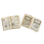
(ATLAS): RAPIN De Thoyras, Paul; Engraved by Basire: Atlas of Rapin’s History of England, No title page, Just 37 Double Page Maps, Plans & a view:...
MIDDLETON, J: CELESTIAL ATLAS, Containing Maps of All the Constellations Visible in Great Britain with Corresponding Blank Maps of the Stars, engr...

MANUSCRIPT-
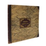
MANUSCRIPT- Exercises in drawing: Plans & Maps, including 25 hand drawn maps of many foreign lands: India, Australia, British America, etc.Provena...

KING Ferdinand II of Aragon:
KING Ferdinand II of Aragon: Notarial Document in Latin of the possession of the town of Casamassina in Puglia (Southern Italy) in 1507, by King F...

MOORE, Jonas:
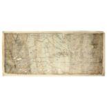
MOORE, Jonas: A Mapp of Ye Great Levell of ye Fens extending into ye Countyes of Northampton, Norfolk, Suffolke, Lyncolne, Cambridge & Huntington ...

MAPS/Marshland-
MAPS/Marshland- Utting, J: 1- Plan of the survey & levels of the sewers, drains, bridges, tunnels & sluices in the parishes of the county of Marsh...

Ordnance Survey Maps:
Ordnance Survey Maps: Cameron & James: Ordnance survey of England & Wales- Rivers & their catchment basins. Southampton, 1867; (1400 x 1080mm), 16...


RAILWAY MAPS:
RAILWAY MAPS: Plan of the section of the Lynn & Ely Railway, with a branch to the harbour at Lynn & main line to Wisbech, survey under the directi...

CHARTS/
CHARTS/Rivers- Hand drawn & coloured Plan of Wisbech canal No.1; from a little beyond Gosmore lane Bridge to Outwell Sluice No.2; nd c18/19; Anoth...

Hanging MAPS:
Hanging MAPS: Runcton Holme. No date, hand coloured, 1200mm wide; with tears; Map of the town of Wisbech with new Walsoken, reduced from the board...

MAPS (Cambs.):
MAPS (Cambs.): Whittlesey Fen: An exact survey of these grounds herein specified.. Being parcel of the possession of W J Cropley of London, taken ...

Hanging MAP, Cambridge & Ely:
Hanging MAP, Cambridge & Ely: Map of the county of Cambridge & Isle of Ely, Surveyed by RG Baker, 1816, 17,18,19,20; republished in Earith, near S...

Bryant, A:
Bryant, A: Map of the county of NORFOLK from actual survey by A Bryant made in the years 1824, 25 & 26, respectfully dedicated to the nobility, cl...


MAPS/Methwold-
MAPS/Methwold- Browne (Surveyor): Plan of the Common Fields Warren & Common in the parish of Methwold, Norfolk, as divided by the act of parliamen...

MAPS/Norfolk-
MAPS/Norfolk- Hand-drawn map on vellum, coloured & with Shield: Some lands belonging to Capt. W. Hudson in the Parishes of Grimston & Bawsey, Norf...

MAPS/Norfolk:
MAPS/Norfolk: Map on vellum of Heacham, copied from the award map, J Browne, Norwich; (720 x 680mm). Hand coloured; little grubby; Copy of the pla...

Bryant, A:
Bryant, A: Map of the county of Lincoln from a survey made in the years 1825, 26 & 27. A Bryant, April 18, 1828. Published in two parts, North and...

Major COLBY:
Major COLBY: Ordnance survey map of Lincolnshire, in 8 parts: 1- Sleaford, Spalding & Newark on Trent; 2- Lincoln, Market Rasen & Horncastle; 3- H...

Map of the County of Lincoln,
Map of the County of Lincoln from an Actual Survey made in the Years 1827 & 1828. Greenwood & Co. Feb. 24, 1830. In three large folding linen back...

MAPS/Fen Drainage-
MAPS/Fen Drainage- Bedford level. April 1789. Folding, linen backed (780 x 580mm), with marbled paper to each end and the original marbled slipcas...
-
37 Los(e)/Seite