Los 1034
Reichsamt für Landesaufnahme (Hrsg.)
Reichsamt für Landesaufnahme (Hrsg.)„Übersichtskarte des Deutschen Reiches 1935“, Reichsamt für Landesaufnahme/ Berlin 1935, 1:1000000, auf Leinen...
Reichsamt für Landesaufnahme (Hrsg.)„Übersichtskarte des Deutschen Reiches 1935“, Reichsamt für Landesaufnahme/ Berlin 1935, 1:1000000, auf Leinen...
Karte LauenburgKarte „Duchè de Lauembourg l `Electeur de Hanover“, altcolorierter Kupferstich, gerahmt, 28,5 x 21,5 cm
Konvolut„Dienststellenplan von Groß Berlin“, Vitalis Verlag 1946/ „Standart Luftbildkarte für Kraftfahrer Plan 25“, Deutsch-Amerikanische Petroleu...
Ratzeburg„Inter Suspiria Luctus - Ratzeburg in Sachsen“, aus Meisners Schatzkästlein um 1630, Original Kupferstich, 7 x 14,5 cm, gerahmt
Karl Baedeker„Die Schweiz nebst den angrenzenden Teilen von Oberitalien, Savoyen und Tirol“, Handbuch für Reisende, Verlag von Karl Baedeker/ Leip...
Konvolut Kriegskarten„Stritt`s Weltkarte“, K.Vowinkel Verlag/ Heidelberg-Berlin 1942/ „Weltkarte“, Verlag G.Westermann/ Berlin 1941/ „Die Kriegssc...
Carl Flemings Generalkarte No. 14„Schleswig Holstein, Mecklenburg, Hamburg, Bremen und Lübeck“, Entworfen v. F. Handtke, 83 x 65 cm, auf Leinen zw...
A beautiful signed limited edition print by Jeremy King, Punting on the Cambridge river, 241 of 250, frame size 81 x 62cm
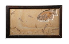
‡ PHAREODUS TESTIS (KNIGHTIA EOCAENA) Medium Eocene 50 m.a White River FMT Kemmerer Wyoming 51cm high, 86cm wide ■ After t...
A MAP OF POOLE HARBOUR 201.5 x 134cm (79¼ x 52¾ in.)
ANONYMOUS AND UNIDENTIFIED Roses; Chrysanthemums; Bamboo, Korea, late 20th century Ink and color or ink on paper, all matted, bamboo with a seal. ...
NEW ENGLAND IN 1830. An Improved Reference and Distance Map of the Eastern Section of New England. New Haven: J.R. Goodno, 1830. Large rolling en...
BLACK (Adam & Charles), 'Blacks General Atlas' comprehending sixty-one maps from the latest and most authentic sources, engraved on steel.... by ...
Tombleson Panoramic map of the Thames published by GW Bacon & Co circa 1890, a coloured engraved map framed and glazed, 127cm x 26cm
THORESBY (Ralph)) Vicaria Leodiensis or the History of the Church in Leedes in Yorkshire' JOSEPH SMITH London 1724 1st Ed (/) 2 maps and 3 plates ...
AIKIN (John) A Description of the Country from thirty to forty miles round Manchester, Stockdale, London, 1795 (1st Ed.?) with maps and plates thr...
SPOTISWOODE (Sir Robert) ‘Practicks of the Laws of Scotland’. John Spotiswoode publisher. Edinburgh 1706, full tooled calf, 310 x 195 mm plus CRAI...
HENNET (G) Cartographer. A map of the County Palatine of Lancaster 1828/9 - A large scale coloured map laid on linen 1600 x 1050mm
STIRLING (Lt. Col. Walter Francis) British Army Officer & Chief Staff Officer to 'Lawrence of Arabia (1880 - 1958) 'Safety Last' Hollis & Carter...
BLOMFIELD. (J.C.) Compiler 'History of the Present Deanery of Bicester, Oxon' Parker & Co., Oxford, 1882. 2 vols with diagrams and maps, 4to, gre...
A George III ordnance Survey map of the Isle of Wight published 1st June 1810 by Lt. Col. Mudge Tower, approx. 670 x 820mm, folding, plus a colle...
An 18th century map of Oxfordshire by Philip Overton on two joined sheets, 59cm x 90cmIn good condition with some minor undulation and marks, fram...
BRYANT (ANDREW) 'Map of the County of Oxford from actual survey ...in the year 1823' inscribed by permission of the Rt. Hon.The Earl of Macclesfie...
GILPIN (WILLIAM) Remarks on Forest Scenery and other Woodland Views…. illustrated by the scenes of New Forest in Hampshire, 3 books in 2 vols, 1st...
John Speed, “Yorkshire”,engraving, Sudbury and Humble, 39 x 51cm; Robert Morden: The West Riding of Yorkshire, 37 x 44cm; and Samuel and Nathanial...
Atlanten - - Riedig, M. Taschen-Atlas über alle Theile der Erde in 24 Karten gezeichnet von M. Riedig. Mit 24 (23 grenzkolorierten) Karten. Leipzi...
A 'FUJIYAMA' HANDSCROLL Japan, 19th century Depicting 19 individual views of Fujiyama, ink and colour on paper. 1280cm (504in) long. Footnotes: 日本...
George Edwards (British, 1694-1773). Group of nine hand-colored etchings from "A Natural History of Uncommon Birds" and "Gleanings of Natural Hist...
Group of two advertising materials for Rapid City, South Dakota and the Black Hills. One 1932 tourist guide pamphlet cover published by the South ...
Richard Bosman (American, b. 1944). Woodcut on paper titled "Flood" depicting a log of driftwood floating in a flood caused by a deluge of rain, 1...
George Edwards (British, 1694-1773). Group of nine hand-colored etchings from "A Natural History of Uncommon Birds" and "Gleanings of Natural Hist...
George Edwards (British, 1694-1773). Group of seven hand-colored etchings from "A Natural History of Uncommon Birds" and "Gleanings of Natural His...
Kenojuak Ashevak (Canadian Inuk, 1927-2013). Stonecut print titled "Radiant Loon," 1998. Pencil signed, titled, numbered 7/50, and inscribed "Dors...
Hand-colored map depicting Minnesota and the Dakota territories. Parts of Wisconsin and Iowa are seen in the margins. Surrounded by a border of fl...
Charles Robert Perrin (American, 1915-1999). Double-sided watercolor on paper painting depicting the prows of sailboats. One side with a seagull a...
George Edwards (British, 1694-1773). Group of ten hand-colored etchings from "A Natural History of Uncommon Birds" and "Gleanings of Natural Histo...
Graeciae novae Tabula. Kupferstichkarte von Griechenland mit Ägäis und Küste der Türkei.Grenz-und flächenkoloriert, wohl aus: Johann David Köhler...
Karte von Ägypten: "Aegyptus Hodierna/ Das heutige Ägypten aus der Reyßbeschreibung desberühmten H. Paul Lucas gezogen und mit folgenden Denckwürd...
Karte des Amtes, der Diözese und Präfektur Dresden.Kupferstich auf Bütten, Doppelbl., koloriert. Rechte unt. Ecke figürliche Kartusche mit gestoch...
Hasui Kawase (Japanese, 1883-1957). Woodblock print titled "Lake Matsubara, Shinshu," 1941. Depicting a seated man fishing in Lake Matsubara. Publ...
Wucius Wong (Chinese, b. 1936). Ink on paper calligraphy painting. Red seals along the left margin.Provenance: From the Distinguished Personal Col...
Tamami Shima (Japanese, 1937-1999). Woodblock print titled "Quiet Morning," 1958. Depicting two cranes in the foreground with several trees in the...
Set of 15 miniature paintings with text, possibly Turkish or Persian. Painted with various tarot themes.Each, height: 8 3/4 in x width: 6 1/4 in.C...
Keisai Eisen (Japanese, 1790-1848). Woodblock aizuri-e print depicting a courtesan in front of a river landscape, ca. 1830s.Height: 14 1/8 in x wi...
Yamanaka & Company, Inc. "Collection of Chinese and Other Far Eastern Art: Assembled by Yamanaka & Company, Inc. Now in Process of Liquidation Und...
Utagawa Toyokuni I (Japanese, 1769-1825). Woodblock print triptych titled "Gogatsu ni Enoshima.. No zu (Fifth Month: A Pilgrimage to Enoshima)," f...
Soseki Komori (Japanese, act. 1920s). Woodblock print on paper ittled "Wild Ducks," ca. 1929-1931. Depicting two mallards. Seal in plate along the...
Hodo Nishimura (Japanese, act. 1930s). Woodblock print on paper titled "Daffodils." Likely published by Takemura Hideo; inkstamp "Made in Japan" a...
Hodo Nishimura (Japanese, act. 1930s). Woodblock print on paper titled "White Lily." Published by Takemura Hideo with an inkstamp along the verso....
Ohara Koson (Japanese, 1877-1945). Woodblock print on paper titled "Flying White-Fronted Goose Seen from Underneath in front of the Moon." Signatu...
Utagawa Sadahide (Japanese, 1807-1873). Bird's eye view woodblock print triptych depicting views of famous places in a river landscape.Each, heigh...
Ansichten.- Konvolut von 22 Blättern mit 27 Stadtansichten, davon 20 Kupferstiche (davon 3 koloriert) und 7 Lithographien. Zwischen 1575 und 1833....
Rheinland-Pfalz.- Ingelheim. Kupferstich von M. Merian, um 1645. 20 x 31 cm.Erhöhte Gesamtansicht der Stadt am Rhein, im Vordergrund links ein Bau...
Weltkarten.- Mappe-Monde Pour indiquer la Charpente des deux Continents et les principales divisions naturelles de l'Ocean... Stahlstichkarte aus ...
Schleswig-Holstein.- Erhebung.- Konvolut von 8 altkolorierten Lithographien (davon 1 doppelt) zur Schleswig-Holsteinischen Erhebung. Hamburg, bei ...
Skandinavien.- 4 Kupferstichkarten (davon 1 teilkoloriert) aus F.A. Schraembls 'Allgemeiner großer Atlas'. Wien, um 1800. Jeweils 23,5 x 29.5 cm. ...
Mecklenburg.- Topographische Special-Karte der Grossherzogthümer Mecklenburg-Schwerin und Mecklenburg-Strelitz ... von R. von Bomsdorff revid. von...
Nordrhein-Westfalen.- Münster In Westphalen. Vor der Belägerung / Belägerung Münster. So von Iro ... und sich den 23 Octobri dißes Jahrs güttliche...
Schleswig-Holstein.- Ratzeburg.- Konvolut von 4 koloriert(en) Ansichten. Jeweils unter Passepartout. 1. Kupferstich aus Kieser-Meissner, um 1623. ...
Ansichten.- Konvolut von ca. 250 Stahlstichen (teils Dubletten, vereinzelt koloriert) mit Ansichten aus Deutschland. Um 1860. Alle unter schlichte...