13
ATLAS OF COLLECTED MAPS. Composite Atlas containing 22 hand-colored engraved maps including a wo...

Das Auktionshaus hat für dieses Los keine Ergebnisse veröffentlicht
New York, New York
Beschreibung
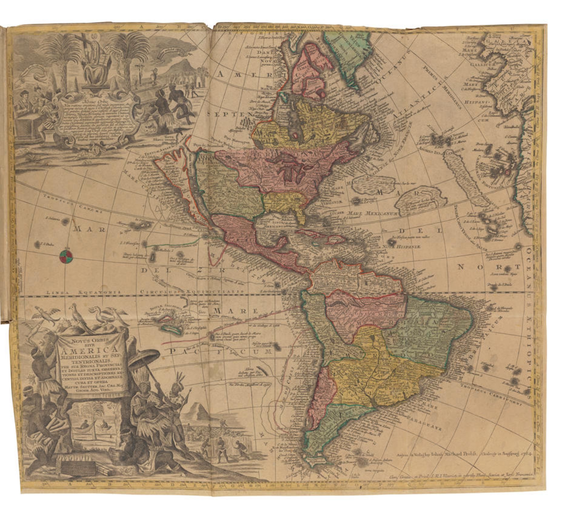
ATLAS OF COLLECTED MAPS. Composite Atlas containing 22 hand-colored engraved maps including a world map, map of America, map of Asia, Africa and multiple maps of Europe. 4to. 18th century vellum, script titles on upper cover (mostly illegible); manuscript listing of contents on back paste-down, listing 30 maps (not accurately reflecting present contents). Maps include: 1. LOWITZ, GEORGE MORITZ. 1722-1774. Planiglobii terrestris. Mappa universalis utrumque Hemisphaerium Orient et Occidentale repraesentans.... Nuremburg: Homann heirs, 1746. Approximately 305 x 455 mm. Separating at vertical folds, some spotting and staining. 2. SEUTTER, MATTHAEUS. 1678-1756. Asia cum omnibus Imperiis provinciis statibus et Insulis luxta observationes recntissimas et accuratissimas.... Augsburg: Johann Michael Probst, n.d. (c. 1783). 492 x 560 mm. Light soiling, minor spotting. 3. SEUTTER, MATTHAEUS. Africa iuxta navigationes et observationes recentissima .... Augsburg: Johann Michael Probst, (c. 1783). 490 x 570 mm. A few minor stains. 4. SEUTTER, MATTHAEUS. Novus Orbis sive America meridionalis et septentrionalis..... Augsburg: Johann Michael Probst, n.d. (c.1783). 496 x 572 mm. A few spots of dampstaining at corners, separation starting at fold crease. 5. PROBST, JOHAN MICHAEL. 1701-1771. Europa religionis Christianæ a morum et pacis ac belli artium cultu.... [Augsburg: Johann Michael Probst], n.d. 490 x 565 mm. Light soiling and spotting. 5. GUSSEFELD, FRANZ LUDWIG. 1744-1807. Regnorum Hispaniae et Portugalliae tabula generalis ad statum hodiernum in suas provincias divisa.... [Nuremburg: Homann heirs], 1782 (but later). 463 x 605 mm. Separating at vertical folds, light spotting. 6. DE WIT, F. Accuratissima Galliae tabula Gallis vulgo dicta le Royaume de France divisatam in praefecturas.... Amstel: Joachim Ottens, (c.1740). 399 x 582 mm. Separating at one horizontal fold crease, light spotting and toning. 7. LOTTER, TOBIAS CONRAD. 1717-1777. Magni Turcarum dominatoris Imperium per Europam, Asiam, et Africam, se extendens regiones..... [Augsburg: Jacob Christoph Weyerman, 1744.] 500 x 585 mm. Small loss inside printed area at left edge, some spotting, adhesive residue to part of verso. 8. GUSSEFELD, FRANZ LUDWIG. Nouvelle carte geographique de l'Empire d'Allemagne divise en ses cercles & sousdivise en principuates.... Nuremburg: [Homann heirs], 1789. 516 x 538 mm. Two very small holes with losses, toning and light spotting. 9. HOMANN, JOHANN BAPTIST. 1664-1724. Regnum Borussiae gloriosis auspicys serenissimiet potentissimi princip Frederici III.... Nuremburg: 1701. 474 x 566 mm. Light spotting. 10. MAYER, TOBIAS. Helvetia tredecim statibus liberis quos cantone suocant composita.... Nuremburg: Homann heirs, 1751. 420 x 535 mm. Separations starting at fold creases, 40 mm tear at lower left, light spotting and toning. 11. HOMANN, JOHANN BAPTIST. Regni Sueciae in omnes suas subjacentes provincias accurate divisi.... Nuremburg: Johann Baptist Homann, [1710]. 488 x 569 mm. Some separation at folds, minor spotting and browning. 12. GUSSEFELD, FRANZ LUDWIG. Charte das Russische Reich und die von den Tatarn bewohnte laender.... Nuremburg: Homann heirs, 1786. 459 x 606 mm. Separating at vertical fold, browning and spotting. 13. ZANNONI, GIOVANNI ANTONIO RIZZI. 1736-1814. Italia in suos Status divisa ex d'Anvillano Rizzsi Zannonioque prototypis desuintia.... Nuremburg: Homann heirs, 1790. 590 x 435 mm. Separation starting at horizontal fold crease from right edge, some soiling and toning. 14. SANSON, NICHOLAS. 1600-1667. Le Duche de Luxembourg divise en Francois, et Espagnol... Paris: Chez H. Jaillot, 1785. 435 x 578 mm. Light soiling, wear to edges. 15. [HOMANN, JOHANN BAPTIST.] Lotharingia tabula generalis in qua ducatus Lotharingiae et Barri nec non metensi.... Nuremberg: Johann Baptist Homann, [1756]. 487 x 567 mm. Spotting and toning. 16. LOTTER, TOBIAS CONRAD. Circulus Franconicus in quo continentur episcopat. Wuertzburgens Bambergensis et Auchstadiensis.... [Augsburg: Matthaeus Seutter, 1744.] 495 x 575 mm. Light soiling. 17. LOTTER, TOBIAS CONRAD. Nova et accuratissima Ducatus Wurtenbergici cum territoriis conterminis.... [Augsburg: Lotter], n.d. 497 x 585 mm. Light wear and soiling. 18. [HOMANN, JOHANN BAPTIST.] Neu vermehrte post charte durch gantz Teutschland nach Italien, Franckreich, Niederland, Preussen, Polen und Ungarn.... Nuremburg: Johann Baptist Homann, [1762]. 452 x 557. Separations at folds, scattered staining and soiling. 19. GUSSEFELD, FRANZ LUDWIG. Der suedliche Theil des Bisthums Luettich erhaltend der land Condros.... Nuremburg: Homann heirs, 1790. 726 x 585 mm. Some separation at corners of fold creases, light dampstaining. 20. LOTTER, TOBIAS CONRAD. XVII Provinciae Belgii sive Germania interioris.... [Augsburg: Lotter, c. 1730]. 489 x 575 mm. Separation at horizontal fold crease, light spotting. 21. [HOMANN, JOHANN BAPTIST.] Ducatus Brabantiae nova tabula in qua lovanii Bruxellarum.... Nuremburg: Johann Baptist Homann, (c.1720). 577 x 474 mm. A few small tears, light dampstaining to lower edge. 22. LOTTER, TOBIAS CONRAD. Superioris atque inferioris Alsatiae tabula perquam accuratsma exacta proximis regionibus.... [Augsburg: Lotter, c. 1760.] 529 x 480 mm. Toned, some stains from hand-coloring. Staining and spotting to covers, inked titles and identifying numbers on verso of each map, some with pasted captions on versos, all maps with margins trimmed closely to edges of printed area. For further information on this lot please visit Bonhams.com For further information about this lot please visit the lot listing
Auktionsdetails
Versand
AGB & Wichtige Informationen
Stellen Sie dem Verkäufer eine Frage
ATLAS OF COLLECTED MAPS. Composite Atlas containing 22 hand-colored engraved maps including a world map, map of America, map of Asia, Africa and multiple maps of Europe. 4to. 18th century vellum, script titles on upper cover (mostly illegible); manuscript listing of contents on back paste-down, listing 30 maps (not accurately reflecting present contents). Maps include: 1. LOWITZ, GEORGE MORITZ. 1722-1774. Planiglobii terrestris. Mappa universalis utrumque Hemisphaerium Orient et Occidentale repraesentans.... Nuremburg: Homann heirs, 1746. Approximately 305 x 455 mm. Separating at vertical folds, some spotting and staining. 2. SEUTTER, MATTHAEUS. 1678-1756. Asia cum omnibus Imperiis provinciis statibus et Insulis luxta observationes recntissimas et accuratissimas.... Augsburg: Johann Michael Probst, n.d. (c. 1783). 492 x 560 mm. Light soiling, minor spotting. 3. SEUTTER, MATTHAEUS. Africa iuxta navigationes et observationes recentissima .... Augsburg: Johann Michael Probst, (c. 1783). 490 x 570 mm. A few minor stains. 4. SEUTTER, MATTHAEUS. Novus Orbis sive America meridionalis et septentrionalis..... Augsburg: Johann Michael Probst, n.d. (c.1783). 496 x 572 mm. A few spots of dampstaining at corners, separation starting at fold crease. 5. PROBST, JOHAN MICHAEL. 1701-1771. Europa religionis Christianæ a morum et pacis ac belli artium cultu.... [Augsburg: Johann Michael Probst], n.d. 490 x 565 mm. Light soiling and spotting. 5. GUSSEFELD, FRANZ LUDWIG. 1744-1807. Regnorum Hispaniae et Portugalliae tabula generalis ad statum hodiernum in suas provincias divisa.... [Nuremburg: Homann heirs], 1782 (but later). 463 x 605 mm. Separating at vertical folds, light spotting. 6. DE WIT, F. Accuratissima Galliae tabula Gallis vulgo dicta le Royaume de France divisatam in praefecturas.... Amstel: Joachim Ottens, (c.1740). 399 x 582 mm. Separating at one horizontal fold crease, light spotting and toning. 7. LOTTER, TOBIAS CONRAD. 1717-1777. Magni Turcarum dominatoris Imperium per Europam, Asiam, et Africam, se extendens regiones..... [Augsburg: Jacob Christoph Weyerman, 1744.] 500 x 585 mm. Small loss inside printed area at left edge, some spotting, adhesive residue to part of verso. 8. GUSSEFELD, FRANZ LUDWIG. Nouvelle carte geographique de l'Empire d'Allemagne divise en ses cercles & sousdivise en principuates.... Nuremburg: [Homann heirs], 1789. 516 x 538 mm. Two very small holes with losses, toning and light spotting. 9. HOMANN, JOHANN BAPTIST. 1664-1724. Regnum Borussiae gloriosis auspicys serenissimiet potentissimi princip Frederici III.... Nuremburg: 1701. 474 x 566 mm. Light spotting. 10. MAYER, TOBIAS. Helvetia tredecim statibus liberis quos cantone suocant composita.... Nuremburg: Homann heirs, 1751. 420 x 535 mm. Separations starting at fold creases, 40 mm tear at lower left, light spotting and toning. 11. HOMANN, JOHANN BAPTIST. Regni Sueciae in omnes suas subjacentes provincias accurate divisi.... Nuremburg: Johann Baptist Homann, [1710]. 488 x 569 mm. Some separation at folds, minor spotting and browning. 12. GUSSEFELD, FRANZ LUDWIG. Charte das Russische Reich und die von den Tatarn bewohnte laender.... Nuremburg: Homann heirs, 1786. 459 x 606 mm. Separating at vertical fold, browning and spotting. 13. ZANNONI, GIOVANNI ANTONIO RIZZI. 1736-1814. Italia in suos Status divisa ex d'Anvillano Rizzsi Zannonioque prototypis desuintia.... Nuremburg: Homann heirs, 1790. 590 x 435 mm. Separation starting at horizontal fold crease from right edge, some soiling and toning. 14. SANSON, NICHOLAS. 1600-1667. Le Duche de Luxembourg divise en Francois, et Espagnol... Paris: Chez H. Jaillot, 1785. 435 x 578 mm. Light soiling, wear to edges. 15. [HOMANN, JOHANN BAPTIST.] Lotharingia tabula generalis in qua ducatus Lotharingiae et Barri nec non metensi.... Nuremberg: Johann Baptist Homann, [1756]. 487 x 567 mm. Spotting and toning. 16. LOTTER, TOBIAS CONRAD. Circulus Franconicus in quo continentur episcopat. Wuertzburgens Bambergensis et Auchstadiensis.... [Augsburg: Matthaeus Seutter, 1744.] 495 x 575 mm. Light soiling. 17. LOTTER, TOBIAS CONRAD. Nova et accuratissima Ducatus Wurtenbergici cum territoriis conterminis.... [Augsburg: Lotter], n.d. 497 x 585 mm. Light wear and soiling. 18. [HOMANN, JOHANN BAPTIST.] Neu vermehrte post charte durch gantz Teutschland nach Italien, Franckreich, Niederland, Preussen, Polen und Ungarn.... Nuremburg: Johann Baptist Homann, [1762]. 452 x 557. Separations at folds, scattered staining and soiling. 19. GUSSEFELD, FRANZ LUDWIG. Der suedliche Theil des Bisthums Luettich erhaltend der land Condros.... Nuremburg: Homann heirs, 1790. 726 x 585 mm. Some separation at corners of fold creases, light dampstaining. 20. LOTTER, TOBIAS CONRAD. XVII Provinciae Belgii sive Germania interioris.... [Augsburg: Lotter, c. 1730]. 489 x 575 mm. Separation at horizontal fold crease, light spotting. 21. [HOMANN, JOHANN BAPTIST.] Ducatus Brabantiae nova tabula in qua lovanii Bruxellarum.... Nuremburg: Johann Baptist Homann, (c.1720). 577 x 474 mm. A few small tears, light dampstaining to lower edge. 22. LOTTER, TOBIAS CONRAD. Superioris atque inferioris Alsatiae tabula perquam accuratsma exacta proximis regionibus.... [Augsburg: Lotter, c. 1760.] 529 x 480 mm. Toned, some stains from hand-coloring. Staining and spotting to covers, inked titles and identifying numbers on verso of each map, some with pasted captions on versos, all maps with margins trimmed closely to edges of printed area. For further information on this lot please visit Bonhams.com For further information about this lot please visit the lot listing
Fine Books and Manuscripts
Endet ab
Ort der Versteigerung
580 Madison Avenue
New York
New York
10022
United States
...
Wichtige Informationen
This auction is now finished. If you are interested in consigning in future auctions, please contact the specialist department. If you have queries about lots purchased in this auction, please contact client services.
You are advised to visit www.bonhams.com for any additional information regarding auction 30376 which may have come to light for any Lot after producing the catalogue, which will be included in a "Sale Room Notice" accompanying each Lot.
AGB
https://www.bonhams.com/legals/
Vollständige AGBs