Verfeinern Sie Ihre Suche
Auktionshaus-Kategorie
Kategorie
- Arms, Armour & Militaria (46)
- Books & Periodicals (22)
- Maps (11)
- Collectables (3)
- Photographs (2)
- Bank notes (1)
- Cameras & Camera Equipment (1)
- Coins (1)
- Drawings & Pastels (1)
- Entertainment Memorabilia (1)
- Metalware (1)
- Models, Toys, Dolls & Games (1)
- Oil, Acrylic paintings & Mixed Media (1)
- Prints (1)
- Sporting Memorabilia & Equipment (1)
- Stamps (1)
- Watches & Watch accessories (1)
- Liste
- Galerie
-
96 Los(e)/Seite
Ein Abonnement der Preisliste ist notwendig um Ergebnisse, von Auktionen die vor einem längeren Zeitraum als 10 Tagen stattgefunden haben, ansehen zu können. Klicken Sie hier für mehr Informationen


Two Original WWII Period German Cinefilms, One German seaplanes Training film (Lehrfilm) & second is an Anti Aircraft Defence Unit. Both in origin...

Queen Elizabeth and Prince Phillips 1954 Tour of Australia. Fascinating "Official" red and gilt Phot
Queen Elizabeth and Prince Phillips 1954 Tour of Australia. Fascinating "Official" red and gilt Photograph Album compiled by a member of the SS Go...

Small collection of photographs
Small collection of photographs, some press including Princes Margaret at a "Ball" 30-4-82, Housewives join the Smithfield war 1956, Two images o...

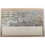
The Road from Ipswich Suffolk to Norwich.. Copper Engraved, hand coloured, believed Plate 74 from Britannia by Ogilby no date believed 1675 45cms ...

"Seymour" Three Humorous Home Guard Pen & Ink Drawings, with links to Bexhill HG. Original drawin in 1942 these are more modern prints on card ea...

Fantastic Example of a 2nd Battalion Royal Sussex Regiment Embroidery, fine example dating from the early part of the 20th century, with crossed ...

Original Artwork of Normandy and D-Day Interest by G.H.Davis, the well known Artist whose realistic portrayal of aircraft, vehicles, ships, many o...
Original Artwork by G.H.Davis Illustrating the Rhine River from Wesel to Coblenz, together with an inset image of six Rhine bridges demonstrating ...

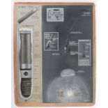
Original Artwork by G.H.Davis Illustrating the Infra-Red Technology used by the Germans at the end o
Original Artwork by G.H.Davis Illustrating the Infra-Red Technology used by the Germans at the end of World War II. Of the 8 individual drawings m...
Original Artwork by G.H.Davis illustrating Parachute Flares both in operation and with his excellent cutaway illustrations. Signed by Davis and da...

Original Artwork by G.H.Davis, View of Lake Bizerta and the town of Bizerta and the surrounding area. Probably drawn to support article on Allied ...

Original Artwork by G.H.Davis Mix of Images including Magnetic mines and counter measures, use of heavier bombs by the RAF up to 22,000 lbs, Rocke...
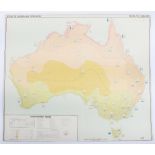
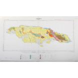
Atlas of Australia
Atlas of Australia, large scale detailed maps showing Mineral resources, Climatic Regions etc 18 sheets,
Series of Original Provisional Maps of the Admiralty Islands in the Bismarck Sea, the scene of an American invasion in 1944 against the Japanese. ...
Maps Spain 1:50,000 1929 onwards
Maps Spain 1:50,000 1929 onwards Includes Betanzos and Pedrola c.45 sheets,
Maps,GSGS4567 Sweden 1:300K WW2 Period, 7 sheets, generally good condition
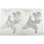
Maps, Rijksdienst Voor Het National Plan (Holland), c 1947, 27 sheets see images,

Maps, Zusamendruck aus der Karte des Deutschen Reich, 1:100K Includes Kreis Kolberg-Korlin, Kreis Rastenburg, Kreis Heilsberg etc. 25 sheets,

Maps, GSGS 4332 Belgium/NE France 1:,100K WWII Period. Includes Rheims, Arlon, Liege & Masesyck. 4 in all, ...[more]

Maps, Holland 1:25K TDN M833 Ministry of war Original produced c.1935 reprinted 1c.1954 Includes Deventer, Veenden etc. c.57 sheets in all

Maps, Carte de France also Holland etc. Type 1922, though printing date post WWII mainly 1:50k very large collection of c.117 sheets,
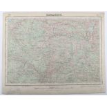
Maps Russia / Central Europe 1:200k post WWI see illustrations 25 Sheets,

GSGS 4136 Ireland 1:63,360. 3rd Edition 1942 25 sheets,

Carte de France Type 1922
Carte de France Type 1922 1:100K Includes St Martin, Lille, Macon 72 sheets,

Carte de France Type 1922
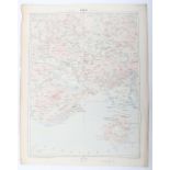
Carte de France Type 1922 1:100K Includes Meziere see images 42 sheets

Karte des Deutschen Reich 1:100K 1930's to 1950's Includes Breslau and Dresden etc. 37 sheets

GSGS 4148 1st Editions Iberian Peninsular 1:250K 1941 Includes Santander & La Corunna etc. 50 sheets, ...[more]
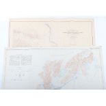
Maps Caribbean various scales
Maps Caribbean various scales, includes Jamaica, Trinidad & Grenada Post WWII. See images 81 sheets, ...[more]

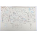
Canada Urban, Very unusual and large (c.3 feet x c. 4 feet) aerial photograph maps c.1965 of Montreal, Toronto, Manitoba & Winipeg. Clearly used f...

WW2 Havre De Portbail, Original Secret paper Map 20th May 1944 1:25,000 scale, showing Beach Defences(Gun emplacements, MG's Mines etc.,) and wi...

Town Plan of Cherbourg
Town Plan of Cherbourg. 1:10,000 Scale Published by War Office 1943 (Third Edition) c.80cms x c.60cms
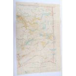
Two Canadian Maps
Two Canadian Maps, one Reconnaissance map of Yukon Tanna Region Alaska Circle Triangle Edition of May 1910 1:250,000 (Alaska sheet 641) & two Cont...

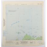
Maps, Interesting map of Charleville, City Plan, 1:5000. 1944. Produced by (US ) Army map service First Edition c.40cms x c 70cms. Uncommon, with ...

Map Tivat Naval Dockyard (in Zeljanoyo Bay)scale 1 inch to 250 feet. War Office 1943. Seems to have has Submarine facilities. C.40 x c.40cms, pape...
East Lillooet Sheet, Department of Lands, British Columbia, Jan 4th 1926 Large coloured map, scale 2miles to 1 inch. c.40 X c.75cms. Interesting m...

Kiel Canal 1:12,500 First Edition sheet 8 GSGS 4522 War Office 1945. c.40 x c.50cms,
-
96 Los(e)/Seite