Verfeinern Sie Ihre Suche
Auktionshaus-Kategorie
Kategorie
Sortieren nach:
- Künstler / Marke
- Liste
- Galerie
-
181 Los(e)/Seite
Ein Abonnement der Preisliste ist notwendig um Ergebnisse, von Auktionen die vor einem längeren Zeitraum als 10 Tagen stattgefunden haben, ansehen zu können. Klicken Sie hier für mehr Informationen


France.- Paris.- Vue Generale de l'Exposition Universelle et des Constructions elevees dans le …
France.- Paris.- Vue Generale de l'Exposition Universelle et des Constructions elevees dans le Parc, wood-engraved bird's-eye view of the exhibiti...

France.- Paris.- Crépy (Jean Baptiste) Nouveau Plan Routier de la Ville et Faubourg de Paris, 1763.
France.- Paris.- Crépy (Jean Baptiste) Nouveau Plan Routier de la Ville et Faubourg de Paris, engraving with hand-colouring, sheet 570 x 790 mm (2...

Germany.- Mejer (Johannes) Newe Landcarte von denbeiden Herzogthumbern Schleswieg und Holstein, …
Germany.- Mejer (Johannes, 1606-1674) Newe Landcarte von denbeiden Herzogthumbern Schleswieg und Holstein, Anno 1650, engraved map of Schleswig-Ho...

Germany.- Serlin (Wilhelm) Eigentliche Anweisung wie dess Heiligen Reichstatt Bremen im Jahr 1666 …
Germany.- Serlin (Wilhelm) Eigentliche Anweisung wie dess Heiligen Reichstatt Bremen im Jahr 1666 vom 30 Augusti bis den 15 Novemb. ... beschlosse...
![Germany.- Nell (Johann Peter) Neu-vermehrte Post-Charte durch gantz Teutschland, [c. 1730].](https://portal-images.azureedge.net/auctions-2020/forum-10235/images/48b213ff-82c8-4537-8598-ac3f00c79948.jpg?w=155&h=155)
Germany.- Nell (Johann Peter, 1672-1743) Neu-vermehrte Post-Charte durch gantz Teutschland, engraved map with original hand-colouring in outline, ...

Germany.- Hamburg.- Homann Heirs. Des Heil. Rom. Reichs freye Handels u. Hansee Stadt Hamburg in …
Germany.- Hamburg.- Homann's Heirs. Des Heil. Rom. Reichs freye Handels u. Hansee Stadt Hamburg in einem accuraten Plan u. Prosp., engraved plan a...

Holy Land.- Jerusalem.- Savery (Jacob) De Heylige en Wytvermaerde Stadt Ierusalem Eerst Genaemt …
NO RESERVE Holy Land.- Jerusalem.- Savery (Jacob) De Heylige en Wytvermaerde Stadt Ierusalem Eerst Genaemt Salem, imaginary bird's-eye view of anc...

Holy Land.- Sanson (Nicolas) Judaea seu Terra Sancta quae Hebraeorum sive Israelitarum, 1696.
Holy Land.- Sanson (Nicolas) Judaea seu Terra Sancta quae Hebraeorum sive Israelitarum, large map of the Holy Land divided into tribes, engraving ...

Holy Land.- Conder (Thomas) A Map of The Land of Canaan, 1799; and 2 others of the region (3)
Holy Land.- Conder (Thomas) A Map of The Land of Canaan, engraving with hand-colouring, 350 x 360 mm (13 3/4 x 14 1/8 in), old folds as issued, ha...

Holy Land.- Clarke (Samuel) The Holy Land, large folding wall map showing from Damascus to Petra, with inset maps of the topography of Jerusalem a...

Holy Land.- Wilson (Capt. Charles) Ordnance Survey of Jerusalem, lithograph, 1170 x 780 mm (46 x 30 3/4 in), dissected and mounted on linen, foldi...

NO RESERVE Hong Kong.- War Office (The, Geographical Section) Hong Kong and the New Territories, third edition, Ordnance Survey map, lithograph pr...

India.- Harrison (John) A Map of India Drawn From D'Anville's two Sheet Map, With Improvements, …
India.- Harrison (John) A Map of India Drawn From D'Anville's two Sheet Map, With Improvements, showing India and Ceylon, with part of the coast o...

India.- Faden (William) The Southern Countries of India from Madrass to Cape Comorin, Describing the Routes of the Armies Commanded by Colonels Fu...

India.- Rennell (James) A Map of the North Part of Hindostan or A Geographical Survey of the …
India.- Rennell (James) A Map of the North Part of Hindostan or A Geographical Survey of the Provinces of Bengal, Bahar, Awd, Ellahabad, Agra and ...

India.- Wyld (James) Map of the Peninsula of India, from the 19th Degree of North Latitude, to …
India.- Wyld (James) Map of the Peninsula of India, from the 19th Degree of North Latitude, to Cape Comorin, large two-sheet map of India with par...

India & Australia.- Daussy (Pierre) Carte Générale de la mer des Indes; Carte des mers Australes, …
India & Australia.- Daussy (Pierre) Carte Générale de la mer des Indes; Carte des mers Australes, two large detailed sea charts, the first showing...

India & Sri Lanka.- Baldaeus (Philippus) Collection of 17 maps, plans and views of Ceylon and …
India & Sri Lanka.- Baldaeus (Philippus) Collection of 17 maps, plans and views of Ceylon and India, inlcuding 'Regnum Jafnapatnam', 'Negumbo', 'A...

India & Sri Lanka.- Coronelli (Vincenzo Maria) Penisola dell' Indo di qua del Gange, e l'Isola di …
India & Sri Lanka.- Coronelli (Vincenzo Maria) Penisola dell' Indo di qua del Gange, e l'Isola di Ceilan nell' Indie Orientali Descritta..., map o...

Indonesia.- Stemfoort (J.W.) and J.J. Ten Siethoff. Atlas van Nederlandsch Oost-Indië, 21 maps of …
Indonesia.- Stemfoort (J.W.) and J.J. Ten Siethoff. Atlas van Nederlandsch Oost-Indië, title with inset key map, 21 maps on 16 double-pages, litho...

Italy.- Homann (Johann Baptist) Regnorum Siciliae et Sardiniae nec non Melitae seu Maltae insula..., map showing Sicily, Sardinia, and Malta, with...

Italy.- Rizzi-Zannoni (Giovanni Antonio) Li Regni di Sicilia, e Sardegna, colle adiacenti isole di …
Italy.- Rizzi-Zannoni (Giovanni Antonio) Li Regni di Sicilia, e Sardegna, colle adiacenti isole di Corsica, Elba, Malta, e Liparee..., engraving w...
![Sicily.- Merian (Matthaeus) Sicilia Regnum, [c. 1640].](https://portal-images.azureedge.net/auctions-2020/forum-10235/images/928033fb-fb6c-4273-b9d3-ac3f00c72fee.jpg?w=155&h=155)
Sicily.- Merian (Matthaeus) Sicilia Regnum, engraved map with full hand-colouring, on laid paper with watermark of an eagle, sheet 295 x 360 mm (1...

Italy.- Venice.- Laurie & Whittle (publishers) A View from St. Marks Pillar at Venice; A View of …
Italy.- Venice.- Laurie & Whittle (publishers) A View from St. Marks Pillar at Venice; A View of the Bridge on the Canal Reggio, a pair of vue d'o...

Sicily & Malta.- Smyth (Admiral William Henry) [The Hydrography of Sicily, Malta, and the adjacent …
Sicily & Malta.- Smyth (Admiral William Henry) [The Hydrography of Sicily, Malta, and the adjacent islands; surveyed in 1814, 1815, and 1816], let...
![Middle East.- Ortelius (Abraham) Persici sive Sophorum Regni Typus, [c. 1590].](https://portal-images.azureedge.net/auctions-2020/forum-10235/images/2c600f2a-ddd8-4636-9cd2-ac3f00c758df.jpg?w=155&h=155)
Middle East.- Ortelius (Abraham) Persici sive Sophorum Regni Typus, Persia from the Caspian Sea to the Red Sea with strapwork title cartouche in t...

Middle East.- Speed (John) The Turkish Empire, showing from Italy to Saudi Arabia, with decorative title cartouche lower left, 8 city plans and vi...

Middle East.- Vaugondy (Gilles Robert de) Antiquor? Imperiorum Tabula, in qua Prae Caeteris, …
Middle East.- Vaugondy (Gilles Robert de) Antiquor? Imperiorum Tabula, in qua Prae Caeteris, Macedonicum seu Alexandri Magni Imperium et Expeditio...
![Turkey.- Münster (Sebastian) Constantinopel des Griechischen Keyserchumbs Hauptstatt, [c. 1550].](https://portal-images.azureedge.net/auctions-2020/forum-10235/images/e872ea71-ae5c-46f3-ba50-ac3f00c785f2.jpg?w=155&h=155)
Turkey.- Münster (Sebastian) Constantinopel des Griechischen Keyserchumbs Hauptstatt, [c. 1550].
Turkey.- Istanbul.- Münster (Sebastian) Constantinopel des Griechischen Keyserchumbs Hauptstatt/ im Land Thracia am Moere Gelegen, bird's-eye view...

Middle East.- Turkish Empire.- Homann (Johann Baptist) Imperium Turcicum in Europa, Asia et Africa …
Middle East.- Turkish Empire.- Homann (Johann Baptist) Imperium Turcicum in Europa, Asia et Africa Regiones Proprias, Tributarias, Clientelares .....

Middle East.- Red Sea.- d'Anville (Jean Baptiste Bourguignon) Persian Gulph From the Original by …
Middle East.- Red Sea.- d'Anville (Jean Baptiste Bourguignon), After. Persian Gulph From the Original by D'Anville, chart of the Persian Gulf by G...

Middle East.- Cassini (Giovanni Maria) Gli Imperi Antichi Parte Occidentale; Gli Imperi Antichi …
Middle East.- Cassini (Giovanni Maria) Gli Imperi Antichi Parte Occidentale; Gli Imperi Antichi Parte Orientale, two part map of the Turkish Empir...

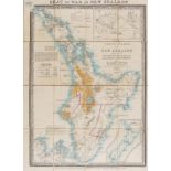
New Zealand.- Wyld (James) Chart of New Zealand from Original Drawings, Third Edition, important map of the North and South Islands, with little i...

New Zealand.- Reid (John) Map of the Province of Otago New Zealand, hanging lithographic wall map with hand-colouring, 1080 x 980 mm (42 1/2 x 38 ...
New Zealand.- Seat of War.- Wyld (James) The North Island of New Zealand embracing the country …
New Zealand.- Seat of War.- Wyld (James) The North Island of New Zealand embracing the country round Auckland, Wellington & New Plymouth, inset ma...

New Zealand.- Public Works Dept. (Methven) Map showing Irrigation Development in the South Island …
New Zealand.- Public Works Dept. (Methven, publisher) Map showing Irrigation Development in the South Island N.Z., colour-printed map, signed in i...

Norway .- Homann (Johann Baptist) Regni Norvegiae..., inset map showing the the northern part of Norway, decorative title cartouche in the lower l...
![Pakistan, Afghanistan & Northern India.- Blaeu (Willem Jansz.) Magni Mogolis Imperium, [c. 1660].](https://portal-images.azureedge.net/auctions-2020/forum-10235/images/0a4cac1f-62bd-49a0-b287-ac3f00c823e2.jpg?w=155&h=155)
Pakistan, Afghanistan & Northern India.- Blaeu (Willem Jansz.) Magni Mogolis Imperium, [c. 1660].
Pakistan, Afghanistan & Northern India.- Blaeu (Willem Jansz.) Magni Mogolis Imperium, map of the Empire of the Great Mogul in northern India incl...

Poland.- Zatta (Antonio) Il Regno di Polonia con le Provincie ora Possedute dalle tre Confinanti …
Poland.- Zatta (Antonio) Il Regno di Polonia con le Provincie ora Possedute dalle tre Confinanti Potenze Prussia Russia e Casa d' Austria, map of ...

Poland.- Hérisson (Eustache) 1806 Carte du Royaume de Prusse, de la Pologne et de la Lithuanie, Ou …
Poland.- Hérisson (Eustache) 1806 Carte du Royaume de Prusse, de la Pologne et de la Lithuanie, Ou l'on trouse une partie de la Russie Et ou l'on ...

Russia.- Sanson (Nicolas) Description de la Tartarie Tiree en Partie de Plusieurs Cartes, 1654; …
NO RESERVE Russia.- Sanson (Nicolas) and Pierre Mariette. Description de la Tartarie Tiree en Partie de Plusieurs Cartes, map of Tartary, showing ...

Russia.- St. Petersburg.- Bowles (John) [View of the Twelve Colleges building and part of the …
Russia.- St. Petersburg.- Bowles (John) [View of the Twelve Colleges building and part of the Merchant's Arcade in St Petersburg], vue d'optique e...

Siege of Belgrade.- March der Kayserlichen Armee von Futak bis Belgrad Anno 1717; Prospect der …
Siege of Belgrade.- March der Kayserlichen Armee von Futak bis Belgrad Anno 1717; Prospect der Vestung Belgrad, two-part engraving, the top half a...
![Spain.- Ortelius (Abraham) Hispalensis Conventus Delineato, [c. 1584].](https://portal-images.azureedge.net/auctions-2020/forum-10235/images/efc994d1-72d5-4e16-98aa-ac3f00c781f0.jpg?w=155&h=155)
Spain.- Ortelius (Abraham) Hispalensis Conventus Delineato, engraved map of Andalucia with original hand-colouring, the greens faded to brown, 350...

Spain.- Harris (John) An exact Plan of Barcelona with its Fortifications Surveyd by the French, …
NO RESERVE Spain.- Harris (John) An exact Plan of Barcelona with its Fortifications Surveyd by the French, with inset maps of Catalonia and Spain,...

Switzerland.- Jaillot (Alexis-Hubert) La Suisse Divisee en Ses Treze Cantons, Ses Alliez & Ses …
Switzerland.- Jaillot (Alexis-Hubert) and Nicolas Sanson. La Suisse Divisee en Ses Treze Cantons, Ses Alliez & Ses Sujets, map showing Switzerland...
![Switzerland.- Blaeu (Willem Jansz.) Das Wiflispurgergow [1687]](https://portal-images.azureedge.net/auctions-2020/forum-10235/images/5bbe9a6b-e082-43f8-a74d-ac3f00c794a2.jpg?w=155&h=155)
Switzerland.- Blaeu (Willem Jansz.) Das Wiflispurgergow, map of Southwestern Switzerland after Mercator, with ornamental title cartouche and showi...

Switzerland.- Homann Heirs (publishers) Helvetia Tredecim Statibus Liberis..., Switzerland divided into cantons, title bordered by coats of arms, ...

Switzerland.- Mallet (Henri) Partie occidentale et méridionale de la Suisse et Païs de Vallais, …
Switzerland.- Mallet (Henri) Partie occidentale et méridionale de la Suisse et Païs de Vallais, map showing the Haute-Savoie, part of southern Swi...

Switzerland.- Collection of 5 maps in cassetta-style frames, including 'Des Kantons Lucern Nordlicher Theil', 'Der Kanton Solothurn', 'Basiliensis...
![Alps.- Matterhorn.- Kümmerly & Frey (publishers) Visp/ Viège-Zermatt-Gornergrat, [c. 1926]; and …](https://portal-images.azureedge.net/auctions-2020/forum-10235/images/e977c216-fd60-40f4-8dcb-ac3f00c77e19.jpg?w=155&h=155)
Alps.- Matterhorn.- Kümmerly & Frey (publishers) Visp/ Viège-Zermatt-Gornergrat, [c. 1926]; and …
Alps.- Matterhorn.- Kümmerly & Frey (publishers) Visp/ Viège-Zermatt-Gornergrat, map of the Swiss and Italian Alps centred on Zermatt, lithograph ...

Atlases.- Speed (John) Title and frontispiece for 'The Theatre of the Empire of great Britaine', …
Atlases.- Speed (John) Title and frontispiece for 'The Theatre of the Empire of great Britaine', two sheets, engravings with full hand-colouring, ...
![Atlases.- World.- Teesdale (Henry) [A New General Atlas of the World], [c. 1834].](https://portal-images.azureedge.net/auctions-2020/forum-10235/images/ccd4cd09-d9d5-47f2-8fef-ac3f00c855e4.jpg?w=155&h=155)
*** Please note, the description has changed Atlases.- World.- Teesdale (Henry) [A New General Atlas of the World], lacking title and contents, wi...

*** Please note, the description has changed Atlases.- World.- Teesdale (Henry) A New General Atlas of the World, engraved vignette title, lacking...
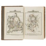
Atlases.- England and Wales.- Cary (John) Cary's Travellers's Companion; or, a Delineation of the …
*** Please note, the description of this lot has changedAtlases.- England and Wales.- Cary (John) Cary's Travellers's Companion; or, a Delineation...

Atlases.- World.- Morrison (John) The Edinburgh New Cabinet Atlas embracing the most recent …
Atlases.- World.- Morrison (John) The Edinburgh New Cabinet Atlas embracing the most recent discoveries, pictorial title, index, and 31 single she...

Atlases.- World.- Black (Adam and Charles) Black's General Atlas of The World, New and Revised …
Atlases.- World.- Black (Adam and Charles) Black's General Atlas of The World, New and Revised Edition, frontispiece with flags of nations, title,...

Atlases.- Reynolds (James) Reynolds's Geological Atlas of Great Britain, 1890; and 5 others (6)
NO RESERVE Atlases.- Reynolds (James) Reynolds's Geological Atlas of Great Britain, frontispiece vignette showing the mountains and hills of Engla...

Arabic atlas.- Brocktorff (Frederico) Atlas, ay majmu' kharitat rasm al-ard..., published in …
Arabic atlas.- Brocktorff (Frederico, Maltese map publisher) Atlas, ay majmu' kharitat rasm al-ard..., 11 hand-coloured lithographic maps, includi...

India.- Calcutta-published atlas.- Tassin (Jean-Baptiste) School Atlas, 1835; and another (2)
NO RESERVE India.- Calcutta-published atlas.- Tassin (Jean-Baptiste) School Atlas, 12 double-page lithographed maps with original hand-colouring, ...
-
181 Los(e)/Seite