Verfeinern Sie Ihre Suche
Auktionshaus-Kategorie
Kategorie
Sortieren nach:
- Nur Massenlose anzeigen
- Liste
- Galerie
-
181 Los(e)/Seite
Ein Abonnement der Preisliste ist notwendig um Ergebnisse, von Auktionen die vor einem längeren Zeitraum als 10 Tagen stattgefunden haben, ansehen zu können. Klicken Sie hier für mehr Informationen


NO RESERVE Manuscript atlases.- Irwin (Miss Frances) Atlas of Modern Geography, pen and ink title, contents, and 24 manuscript maps, including a ...
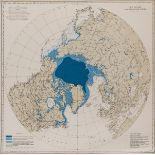
Polar.- Atlas.- Hydrographic Office, U.S. Navy. Ice Atlas of the Northern Hemisphere, first …
Polar.- Atlas.- Hydrographic Office, U.S. Navy. Ice Atlas of the Northern Hemisphere, first edition, 'Index Chart' as front pastedown, full- and h...

Game.- Spooner (William, publisher) The Travellers of Europe; with improvements and additions, geographic game board featuring Europe, North Afric...

Game.- Wallis (J. & E.) The Royal Game of British Sovereigns Exhibiting the Most Remarkable Events …
Game.- Wallis (J. & E.) The Royal Game of British Sovereigns Exhibiting the Most Remarkable Events in Each Reign From Egbert to George III, spiral...

Map reference books.- Wright (Thomas) Clavis Cœlestis being the Explication of a Diagram entitled, …
NO RESERVE Map reference books.- Wright (Thomas) Clavis Cœlestis being the Explication of a Diagram entitled, a Synopsis of the Universe, edited b...
![British Isles.- Münster (Sebastian) Tabula Europae I, [c. 1540-1570]](https://portal-images.azureedge.net/auctions-2020/forum-10235/images/048e6271-13b4-4e99-9b7a-ac3f00c7e43f.jpg?w=155&h=155)
NO RESERVE British Isles.- Münster (Sebastian) Tabula Europae I, Ptolemaic map on a trapezoidal projection, two panels of text list the ancient tr...

British Isles.- Ortelius (Abraham) Angliae, Scotiae, et Hiberniae, sive Britannicar Insularum …
British Isles.- Ortelius (Abraham) Angliae, Scotiae, et Hiberniae, sive Britannicar Insularum Descriptio, Ortelius' earliest map of Britain, orien...

British Isles.- Speed (John) Britain as it was devided in the tyme of the Englishe Saxons especially during their Heptarchy, decorative map of the...
![British Isles.- Jansson (Jan) Magnae Britanniae et Hiberniae nova descriptio, [c. 1646].](https://portal-images.azureedge.net/auctions-2020/forum-10235/images/e3e7bb32-a462-4eec-b7c6-ac3f00c79f86.jpg?w=155&h=155)
British Isles.- Jansson (Jan) Magnae Britanniae et Hiberniae nova descriptio, inset map of the Orkney Islands in the upper right corner, numerous ...

British Isles.- English Civil War.- Hollar (Wenceslaus), After. [Broadside comparing the civil …
British Isles.- English Civil War.- Hollar (Wenceslaus), After. [Broadside comparing the civil wars in England and Bohemia], bird's eye view of Br...
![British Isles.- Bacon (George W.) New Large Scale Ordnance Atlas of the British Isles..., [c. 1883].](https://portal-images.azureedge.net/auctions-2020/forum-10235/images/1e9e311b-f0b1-4a7e-a1ec-ac3f00c82087.jpg?w=155&h=155)
British Isles.- Bacon (George W.) New Large Scale Ordnance Atlas of the British Isles..., [c. 1883].
*** Please note, the description of this lot has changed ***British Isles.- Bacon (George W., publisher) New Large Scale Ordnance Atlas of the Bri...

Britain.- Mogg (Edward) A New Travelling Map of England, Wales and Scotland, engraving with original hand-colouring, 770 x 620 mm (30 x 24 in), di...

England & Wales.- Ortelius (Abraham) Angliae Regni Florentissimi Nova Descriptio Auctore Humfredo …
England & Wales.- Ortelius (Abraham) Angliae Regni Florentissimi Nova Descriptio Auctore Humfredo Lhuyd Denbygiense, map of England and Wales comp...

NO RESERVE England & Wales.- Ortelius (Abraham) and Lhuyd Humphrey. Cambriae Typus Auctore Humfredo Lhuydo. Denbigiense Cambrobritano, engraving w...
![England & Wales.- Blaeu (Willem Jansz.) Anglia Regnum, [c. 1635].](https://portal-images.azureedge.net/auctions-2020/forum-10235/images/41db7a7c-30a9-4939-9062-ac3f00c7a5c2.jpg?w=155&h=155)
England & Wales.- Blaeu (Willem Jansz.) Anglia Regnum, decorated with four ships, a scale of miles flanked by sheep and a cherub, and two coats of...

England & Wales.- Speed (John) The Kingdome of England, with eight costumed figures in margins, the seas populated with monsters and ships, engrav...
England & Wales.- Ogilby (John) An Actual Survey of all the Principal Roads of England and Wales, …
England & Wales.- Ogilby (John) An Actual Survey of all the Principal Roads of England and Wales, 2 vol. in 1, titles, the second printed in red a...

England & Wales.- Cary (John) Cary's New and Correct English Atlas being A New Set of County Maps, …
England & Wales.- Cary (John) Cary's New and Correct English Atlas being A New Set of County Maps, engraved title, dedication, list of subscribers...

England & Wales.- Cary (John) The Roads of Great Britain, 1790; and 18 other folding county maps …
England & Wales.- Faden (William) The Roads of Great Britain, second edition, engraved map with outline hand-colouring, 750 x 610 mm (29 1/2 x 24 ...

England.- Bradshaw (George) Bradshaw's Map of Canals, Navigable Rivers, Rail Road &c. in the …
England.- Bradshaw (George) Bradshaw's Map of Canals, Navigable Rivers, Rail Road &c. in the Midland Counties of England from Actual Survey, said ...
![Wales.- Llwyd (Humphrey) & Jan Jansson. Cambriae Typus Auctore, [c. 1660].](https://portal-images.azureedge.net/auctions-2020/forum-10235/images/8a8d1733-4e84-4834-9c9f-ac3f00c85894.jpg?w=155&h=155)
Wales.- Llwyd (Humphrey) & Jan Jansson. Cambriae Typus Auctore, engraving with hand-colouring, 355 x 500 mm (14 x 19 3/4 in), French text verso, u...

Wales.- Blome (Richard) A Mapp of the Principality of South Wales, engraved map by Wenceslaus Hollar, 215 x 325 mm (8 1/2 x 12 3/4 in), bottom lef...

Cornwall and Wales.- Jacobsz (Jacob) Cust van Engelant., van Lezard tot Engelands eynd, de …
Cornwall and Wales.- Jacobsz (Jacob) Cust van Engelant., van Lezard tot Engelands eynd, de Sorlinges..., chart showing the coast of Great Britain ...

Ireland.- Cary (John) Cary's New Map of Ireland, exhibiting the whole of the Turnpike Roads with …
Ireland.- Cary (John) Cary's New Map of Ireland, exhibiting the whole of the Turnpike Roads with the Rivers and Canals, engraving with original ha...

East Midlands.- Speed (John) Rutlandshire, with Oukham and Stanford her bordering Neighbour newely …
East Midlands.- Speed (John) Rutlandshire, with Oukham and Stanford her bordering Neighbour newely described, inset plans of 'Oukham' and 'Stanfor...

East Midlands.- Colby (Lt. Col. Thomas) [Six Ordnance survey maps covering the environs of Lincoln …
NO RESERVE East Midlands.- Colby (Lt. Col. Thomas) [Six Ordnance survey maps covering the environs of Lincoln and Rutland], including sheets LXIV,...
Essex.- Map (A) of the County of Essex from an Actual Survey, John Chapman and Peter André, 1777; …
NO RESERVE Essex.- Map (A) of the County of Essex from an Actual Survey, folding sheet backed onto linen, faint spotting, some slight chipping to...

NO RESERVE Essex.- Cary (John) A Map of Essex from the best Authorities, engraving with hand-colouring, platemark 450 x 550 mm (17 3/4 x 21 3/4 in...

Kent.- River Thames.- Bowles & Carver (publishers) A View of Gravesend in Kent, with Troops …
Kent.- River Thames.- Bowles & Carver (publishers) A View of Gravesend in Kent, with Troops passing the Thames to Tilbury Fort, vue d'optique engr...

Lancashire.- Hennet (George) A Map of the County Palatine of Lancaster, large county map with ornate title and vignette view of the New Custom Hou...
![London.- Münster (Sebastian) Londen oder Lunden die Hauptstatt in Engellande, [1598].](https://portal-images.azureedge.net/auctions-2020/forum-10235/images/bfa28968-ed1f-4ecb-b1cf-ac3f00c79622.jpg?w=155&h=155)
London.- Münster (Sebastian) Londen oder Lunden die Hauptstatt in Engellande, bird's-eye plan/view of Westminster, the City and Southwark, for Mun...
![London.- Blaeu (Johannes) Middle-Sexia, [c. 1645].](https://portal-images.azureedge.net/auctions-2020/forum-10235/images/dfaafdd5-783b-4cbb-abeb-ac3f00c82f8c.jpg?w=155&h=155)
London.- Blaeu (Johannes) Middle-Sexia, with London shown in the lower right corner above a decorative title cartouche, engraving with early hand-...
![London.- Ogilby (John) The Road from London to Hith in Com. Kent, [circa 1676]; and two other road …](https://portal-images.azureedge.net/auctions-2020/forum-10235/images/c8a5b45b-632e-4111-9c8d-ac3f00c7a10b.jpg?w=155&h=155)
London.- Ogilby (John) The Road from London to Hith in Com. Kent, [circa 1676]; and two other road …
London.- Ogilby (John) The Road from London to Hith in Com. Kent, strip road map with London in the lower left corner, engraving with hand-colouri...

London and its environs.- Speed (John) Midle-Sex described with the most famous Cities of London …
London and its environs.- Speed (John) Midle-Sex described with the most famous Cities of London and Westminster, with inset plans and views of St...

London.- Homann Heirs. Regionis, quae est circa Londinum, specialis repræsentatio geographica, 1741.
London.- Homann Heirs. Regionis, quae est circa Londinum, specialis repræsentatio geographica, map of the environs of London, from Maidenhead to B...

London.- Chiswick.- Bowles (Carington) A View of the Garden of the Earl of Burlington, at Chiswick; A View of Cain & Abel Bird-Cage... in Lord Bur...

London.- Kitchin (Thomas) The Environs or Counties Twenty Miles Round London, Drawn from Accurate …
London.- Kitchin (Thomas) The Environs or Counties Twenty Miles Round London, Drawn from Accurate Surveys, from 'London and its Environs Described...

London.- Andrews (John) A New Travelling Map of the Country Round London Extending from the North …
London.- Andrews (John) A New Travelling Map of the Country Round London Extending from the North to South 190 Miles and East to West 150 Miles, e...

NO RESERVE London.- Cary (John) London, Westminster and Southwark, accurately delineated from the latest Surveys, to which is now first added a Co...

London to Brighton.- Edwards (J.) Edwards's Trigonometrical Land Chart in which the situation of …
London to Brighton.- Edwards (J.) Edwards's Trigonometrical Land Chart in which the situation of churches and other remarkable objects are deduced...

NO RESERVE London.- Cross (Joseph) Cross's New Plan of London, 1828, first edition, showing from Canonbury to Camberwell, and from Hyde Park to Ea...

London.- Wallis (Edward) Wallis's Guide for Strangers through London, 1831; and 9 others (10)
London.- Wallis (Edward, publisher) Wallis's Guide for Strangers through London, showing from Hyde Park to Whitechapel, engraving with hand-colour...

London.- Tegg (Thomas) A New Plan of the Cities of London and Westminster, showing from Pentonville to Newington Butts and from Stepney Green to K...

NO RESERVE London.- Thompson (George) A New Map of London and its Environs, from an original Survey, Extending 8 Miles East and West 6 1/4 Miles N...

London.- Illustrated London News (The) London in 1842, taken from the summit of the Duke of York's …
NO RESERVE London.- Illustrated London News (The) London in 1842, taken from the summit of the Duke of York's column, two bird's eye views of Lond...
![London.- Illustrated London News (The) [Panorama of the River Thames in 1845]](https://portal-images.azureedge.net/auctions-2020/forum-10235/images/eddd17c0-d1e6-4724-8ded-ac3f00c7478a.jpg?w=155&h=155)
NO RESERVE London.- Illustrated London News (The) [Panorama of the River Thames in 1845], one section only showing from the City of London to Gre...

London.- Cruchley (George Frederick) From the Ordnance Survey of the Country Thirty Miles round …
London.- Cruchley (George Frederick) From the Ordnance Survey of the Country Thirty Miles round London, map of the environs of London showing from...

London.- Newton (William) London Westminster Southwark as in Olden Times shewing the City and …
London.- Newton (William) London Westminster Southwark as in Olden Times shewing the City and Suburbs, large wall map, lithograph printed in colou...

London.- Illustrated London News (The) London from the South Side of the Thames, bird's-eye panorama, from Millbank to St Katherine Dock, with Ken...

NO RESERVE London.- Dower (John James) London, Guide to the International Exhibition, 1862, issued as a supplement to the Illustrated London News,...

London.- Weller (Edward) London, large nine sheet wall map, from the Weekly Dispatch, lithographs with full hand-colouring, conjoined in 3 horizon...

London.- Weller (Edward) London in the Reign of Queen Elizabeth, A Fac-simile (Reduced) of the Map …
London.- Weller (Edward) London in the Reign of Queen Elizabeth, A Fac-simile (Reduced) of the Map by Aggas 1560, bird's-eye plan/view of London, ...

London.- Bacon (George W.) New Large-Scale Ordnance Atlas of London & Suburbs with Supplementary …
***Please note, the description of this lot has changedLondon.- Bacon (George W.) New Large-Scale Ordnance Atlas of London & Suburbs with Suppleme...
![London.- Bacon (George W.) New Map of London, [c. 1880]; and seven others (8)](https://portal-images.azureedge.net/auctions-2020/forum-10235/images/97e7056b-ae3e-481c-9708-ac3f00c7c70b.jpg?w=155&h=155)
NO RESERVE London.- Bacon (George W.) New Map of London, divided into half mile squares & circles, from Cassell's Old & New London, lithograph wit...

London.- Bacon (George W.) Bacon's New Large Scale Atlas of London and Suburbs with Supplementary …
London.- Bacon (George W., publisher) Bacon's New Large Scale Atlas of London and Suburbs with Supplementary Maps, Letterpress Descriptions and Al...

NO RESERVE London.- Davies (Benjamin Rees) Davies' New map of London and its Environs, Showing the New Railway Stations and Other Improvements, fr...

Oxford.- Speed (John) Oxforshire described with ye Citie and the Armes of the Colledges of ye …
Oxford.- Speed (John) Oxforshire described with ye Citie and the Armes of the Colledges of ye famous university, county map with inset town plan o...

Oxford.- Ogilby (John) The Road from Oxford to Salisbury Com. Wilts Continued to Pool Com. Dorset, …
Oxford.- Ogilby (John) The Road from Oxford to Salisbury Com. Wilts Continued to Pool Com. Dorset, strip road map commencing at Oxford and runs th...

Oxford.- Sayer (Robert) A View of Queen's College (a), University College (b), All Souls College …
Oxford.- Sayer (Robert, publisher) A View of Queen's College (a), University College (b), All Souls College (c), the Steeple of St. Mary's Church ...

Newcastle.- Bowles & Carver (publishers) A South View of Newcastle upon Tyne in the County of …
Newcastle.- Bowles & Carver (publishers) A South View of Newcastle upon Tyne in the County of Northumberland, vue d'optique engraving with full or...
-
181 Los(e)/Seite