Sortieren nach:
- Kategorie
- Liste
- Galerie
-
15 Los(e)/Seite
Dieses Auktionshaus möchte seine Ergebnisse nicht veröffentlichen. Bitte kontaktieren Sie das Auktionshaus bei Fragen direkt.
![[MILITARIA] SESTI, Giovani Battista. Piante delle città, piazze, e castelli fortificati in questo](https://portal-images.azureedge.net/auctions-2023/wannen10184/images/f848e4b7-7066-4b62-a657-b09e014d45a7.jpg?w=155&h=155)

[MILITARIA] SESTI, Giovani Battista. Piante delle città, piazze, e castelli fortificati in questo
Stato di Milano con le loro dichiarazioni. Milan: Agnelli, 1707.Fine copy on thick paper, with contemporary watercolouring, of this first edition ...

FALDA, Giovanni Battista (1643-1678). Recentis Romae ichnographia et hypsographia sive planta et
facies ad magnificentiam qua prioribus annis urbs ipsa directa exculta et decorata est. Nuremberg: Sandrart, 1677.A crisp copy of this scarce Germ...

Edited edition by Mortier of the map originally published by Blaeu in 1672 and dedicated to Cardinal Flavio Chigi, with the arms of the fourteen R...
![[ROME ; PORTRAITS OF CARDINALS]. Effigies nomina et cognomina. Rome: De Rossi, c. 1740.](https://portal-images.azureedge.net/auctions-2023/wannen10184/images/9c5ed273-7937-4433-b259-b09e014db261.jpg?w=155&h=155)
An elegant collection of portraits of cardinals printed on strong paper and with wide margins. Following a chronological order, the first cardinal...

NOLLI, Giovanni Battista (1701-1756). Urbis Romae Ichnographia a Leonardo Bufalino. Nuremberg:
Homann, 1755.Large-format map reproducing the plan published by Leonardo Bufalini in 1551. The intricate plan includes an index identifying 307 pl...
![[ROME]. Pianta topografica di Roma moderna estratta dalla grande del Nolli. Rome: Monaldini, 1837.](https://portal-images.azureedge.net/auctions-2023/wannen10184/images/b3538400-9227-4a60-98f8-b09e014dd729.jpg?w=155&h=155)
[ROME]. Pianta topografica di Roma moderna estratta dalla grande del Nolli. Rome: Monaldini, 1837.
Map with beautiful contemporary colouring showing, in addition to the 14 districts of Rome, the plans of the mausoleum of Santa Costanza, the Chur...
RUGA, Pietro (19th century). Pianta della città di Roma con la indicazione di tutte le antichità
e nuovi abbellimenti. Rome: Monaldini, 1843.Beautiful map of Rome, depicted as an ancient bas-relief with sixteen views of the main monuments on t...
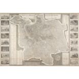
![[ALPS] RAYMOND, Jean-Baptiste (19th century). Carte topographique militaire des Alpes comprenant le](https://portal-images.azureedge.net/auctions-2023/wannen10184/images/8de5c6e9-1944-4283-9c37-b09e014e8361.jpg?w=155&h=155)
[ALPS] RAYMOND, Jean-Baptiste (19th century). Carte topographique militaire des Alpes comprenant le
Piémont, la Savoye, le comté de Nice, le Vallais, le duché de Génes, le Milanais, et partie des états limitrophes. Paris,1820.One of the most impo...

ARROWSMITH, Aaron (1750-1823). A new general atlas. London: Longman, Rees, Orme, Brown & Green,
1827.Atlas with contemporary colouring, the plates of which were designed by Arrowsmith, appointed Hydrographer of the King in 1820.4to, (286 x 23...

Scarce first edition, printed on thick paper, of the first scientific and systematic study of the history of Malta. [Schembri] aggiunge che questa...

CLÉVER, Philipp (1580-1622). Introductio in universam geographiam. Braunschweig: Buno, 1672.
Atlas with over forty folding maps depicting the then-known world.4to, (191 x 155 mm). Engraved title-page preceding typographical title-page, 45 ...
![HAARDT, Vinzenz von (1843-1914). Nord Polar Karte. Vienna: Holzel, [1895].](https://portal-images.azureedge.net/auctions-2023/wannen10184/images/f1da321b-55da-4f3b-a7e9-b09e014e99ae.jpg?w=155&h=155)
Large map in very good condition showing the North Pole area at the time of the great Arctic explorations and showing currents, forest cover, ice ...
![[LIGURIA] CHAFRION, Joseph (1653-1698) Carta del la Riviera de Genova con sus verdaderos confines y](https://portal-images.azureedge.net/auctions-2023/wannen10184/images/6192eeb4-fd8f-41d6-a00c-b09e014e9dec.jpg?w=155&h=155)
[LIGURIA] CHAFRION, Joseph (1653-1698) Carta del la Riviera de Genova con sus verdaderos confines y
caminos...Topographia de la Liguria. Milan: Marcantonio del Re, 1735.An impressive and extremely detailed map of Liguria with the side legends lis...
![[PORTOLAN] BELLIN, Jacques Nicolas (1703-1772); CASSINI DE THURY C?sar-François; . Portolan atlas](https://portal-images.azureedge.net/auctions-2023/wannen10184/images/c2d95724-92b1-4325-b872-b09e014ea79c.jpg?w=155&h=155)
[PORTOLAN] BELLIN, Jacques Nicolas (1703-1772); CASSINI DE THURY C?sar-François; . Portolan atlas
related to the North Atlantic Ocean, Great Britain and France. Paris: , 1742-1757.Portolan nautical chart in contemporary binding, covering the Fr...
![[VENICE] TEMANZA, Tommaso (1705-1789). Antica pianta dell'inclita città di Venezia delineata circa](https://portal-images.azureedge.net/auctions-2023/wannen10184/images/a5edf341-1d6f-4447-acec-b09e014eb22e.jpg?w=155&h=155)
[VENICE] TEMANZA, Tommaso (1705-1789). Antica pianta dell'inclita città di Venezia delineata circa
la metà del XII secolo, ed ora per la prima volta pubblicata, ed illustrata. Venice: Palese, 1781.Excellent uncut copy of this scarce first editio...
-
15 Los(e)/Seite