Mindestpreis nicht eingehalten Keine Abbildung Los 137 Johan Friedrich Leonhard Dreier (Trondheim 1775-1833 Bergen) Views of Norway: Trondheim from the... 137Johan Friedrich Leonhard Dreier (Trondheim 1775-1833 Bergen) Views of Norway: Trondheim from the... Bonhams Johan Friedrich Leonhard Dreier (Trondheim 1775-1833 Bergen) Views of Norway: Trondheim from the East; A prospect of Molde; and Bergen from the So... Auf die Merkliste Timed
Keine Abbildung Los 383 1967 PRINT OF SAXTON'S MAP OF SOMERSET, 1575 BY TAYLOWE LIMITED 3831967 PRINT OF SAXTON'S MAP OF SOMERSET, 1575 BY TAYLOWE LIMITED Auctioneum Ltd - East Bristol & Bath 1967 coloured print of Saxton's Map of Somerset, 1575 by Taylowe Limited. Framed and glazed, measuring approx. 53.5cm x 65.5cm. Auf die Merkliste Live
Keine Abbildung Los 299 C1720 LATIUM CAMPANIA ET SAMNIUM - MAP OF ANCIENT ITALY 299C1720 LATIUM CAMPANIA ET SAMNIUM - MAP OF ANCIENT ITALY Auctioneum Ltd - East Bristol & Bath C1720 Latium Campania et Samnium by AA, Pieter van der - Map engraving of ancient Italy with later colouring, framed and glazed. Complete with cer... Auf die Merkliste Live
Keine Abbildung Los 540 BRISTOL MUSEUM AND ART GALLERY - PHOTOGRAPHS OF MAPS 540BRISTOL MUSEUM AND ART GALLERY - PHOTOGRAPHS OF MAPS Auctioneum Ltd - East Bristol & Bath Bristol Museum and Art Gallery - Late 20th century book of photographs of maps from the collection at Bristol Museum. Including The Citte of Brist... Auf die Merkliste Live
Keine Abbildung Los 53 Charles I (King of England) Basilika [graece]. The Workes of King Charles the Martyr, by James Fl... 53Charles I (King of England) Basilika [graece]. The Workes of King Charles the Martyr, by James Fl... Forum Auctions Charles I (King of England) Basilika [graece]. The Workes of King Charles the Martyr, 2 vol. in 1, engraved frontispiece, additional engraved titl... Auf die Merkliste Live
Keine Abbildung Los 175 Cartographers.- Petermann (Augustus Heinrich, German cartographer, 1822-1878) Autograph Letter si... 175Cartographers.- Petermann (Augustus Heinrich, German cartographer, 1822-1878) Autograph Letter si... Forum Auctions Cartographers.- Petermann (Augustus Heinrich, German cartographer, 1822-1878) Autograph Letter signed, 1p., 8vo, Gotha, 20 February, 1874, discuss... Auf die Merkliste Live
Keine Abbildung Los 81 Broadsides.- Nottingham Politics.- Paid Assassins!, printed broadside, [c.1866]; and 5 others on ... 81Broadsides.- Nottingham Politics.- Paid Assassins!, printed broadside, [c.1866]; and 5 others on ... Forum Auctions Broadsides.- Nottingham Politics.- Paid Assassins!, [c.1866] § All or None. To the Freemen of Nottingham and the Inhabitants Generally, [1839]; To... Auf die Merkliste Live
Keine Abbildung Los 243 India.- Execution of the assassin Sher Ali.- Bombay Gazette Extra edition. Monday March 18, 1872.... 243India.- Execution of the assassin Sher Ali.- Bombay Gazette Extra edition. Monday March 18, 1872.... Forum Auctions India.- Execution of the assassin Sher Ali.- Bombay Gazette. Extra edition. Monday March 18, 1872...Execution of Shere Ali, handbill, folds, littl... Auf die Merkliste Live
Keine Abbildung Los 173 Broadside printed on silk.- Banquetting Hall. Saturday, October 25, 1862, at 9 p.m. musical enter... 173Broadside printed on silk.- Banquetting Hall. Saturday, October 25, 1862, at 9 p.m. musical enter... Forum Auctions Broadside printed on silk in India.- Banquetting Hall. Saturday, October 25, 1862, at 9 p.m. musical entertainment to the Hon'Ble W.A. Morehead, f... Auf die Merkliste Live
Keine Abbildung Los 30 Britain.- Cary (John) Cary's New and Correct English Atlas: being a New Set of County Maps, for J... 30Britain.- Cary (John) Cary's New and Correct English Atlas: being a New Set of County Maps, for J... Forum Auctions Britain.- Cary (John) Cary's New and Correct English Atlas: being a New Set of County Maps, engraved title and dedication, 47 engraved maps (hand-... Auf die Merkliste Live
Keine Abbildung Los 96 Zoroastrianism.- Patrizi (Francesco) [Magia Philosophica hoc est Francisci patricii summi philoso... 96Zoroastrianism.- Patrizi (Francesco) [Magia Philosophica hoc est Francisci patricii summi philoso... Forum Auctions Zoroastrianism.- Patrizi (Francesco) [Magia Philosophica hoc est Francisci patricii summi philosophi zoroaster], lacking title and supplied in man... Auf die Merkliste Live
Keine Abbildung Los 193 Satirical rebus.- King George III.- Laurie & Whittle, publishers. Hierogliphick on the King's Bir... 193Satirical rebus.- King George III.- Laurie & Whittle, publishers. Hierogliphick on the King's Bir... Forum Auctions Satirical rebus.- King George III.- Laurie & Whittle, publishers. Hierogliphick on the King's Birth-day, engraved 'Hierogliphick' and 'A Political... Auf die Merkliste Live
Keine Abbildung Los 11 Europe.- Jigsaw.- Philips' Series of Dissected Maps. Europe, London & Liverpool, c.1875. 11Europe.- Jigsaw.- Philips' Series of Dissected Maps. Europe, London & Liverpool, c.1875. Forum Auctions Europe.- Jigsaw.- Philips' Series of Dissected Maps. Europe, lithographed map printed in colours, mounted on wood and dissected, 330 x 430mm., sli... Auf die Merkliste Live
Keine Abbildung Los 33 England.- Ashburton (Charles Alfred) A New and Complete History of England, From the first Settle... 33England.- Ashburton (Charles Alfred) A New and Complete History of England, From the first Settle... Forum Auctions England.- Ashburton (Charles Alfred) A New and Complete History of England, From the first Settlement of Brutus ... To the Year 1793, engraved fro... Auf die Merkliste Live
Keine Abbildung Los 238 Atlas.- Lopez (Tomas) Atlas Elemental Moderno, Madrid, 1792. 238Atlas.- Lopez (Tomas) Atlas Elemental Moderno, Madrid, 1792. Forum Auctions Atlas.- Lopez de Vargas Machuca (Tomas) Atlas Elemental Moderno, engraved pictorial title, 27 double-page engraved maps and plates, all but 2 hand... Auf die Merkliste Live
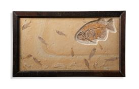
Keine Abbildung Los 151 ‡ PHAREODUS TESTIS (KNIGHTIA EOCAENA) 151‡ PHAREODUS TESTIS (KNIGHTIA EOCAENA) Dreweatts 1759 ‡ PHAREODUS TESTIS (KNIGHTIA EOCAENA) Medium Eocene 50 m.a White River FMT Kemmerer Wyoming 51cm high, 86cm wide ■ After t... Auf die Merkliste Live
Keine Abbildung Los 206 A MAP OF POOLE HARBOUR 206A MAP OF POOLE HARBOUR Dreweatts 1759 A MAP OF POOLE HARBOUR 201.5 x 134cm (79¼ x 52¾ in.) Auf die Merkliste Live
Mindestpreis nicht eingehalten Keine Abbildung Los 692 A 'FUJIYAMA' HANDSCROLL Japan, 19th century 692A 'FUJIYAMA' HANDSCROLL Japan, 19th century Bonhams A 'FUJIYAMA' HANDSCROLL Japan, 19th century Depicting 19 individual views of Fujiyama, ink and colour on paper. 1280cm (504in) long. Footnotes: 日本... Auf die Merkliste Timed
Mindestpreis nicht eingehalten Keine Abbildung Los 226 A Framed Georgian ? Linen Good Sized Fragment incorporating Deer and Swans. H 32cm x W 77.5cm 226A Framed Georgian ? Linen Good Sized Fragment incorporating Deer and Swans. H 32cm x W 77.5cm Phixius Auctions A Framed Georgian ? Linen Good Sized Fragment incorporating Deer and Swans. H 32cm x W 77.5cm Auf die Merkliste Timed


![Charles I (King of England) Basilika [graece]. The Workes of King Charles the Martyr, by James Fl...](https://portal-images.azureedge.net/auctions-2025/forum-10467/images/9719e683-f854-4936-8f3c-b2ce00abb255.jpg?h=175)

![Broadsides.- Nottingham Politics.- Paid Assassins!, printed broadside, [c.1866]; and 5 others on ...](https://portal-images.azureedge.net/auctions-2025/forum-10467/images/e35b47ab-f44e-41a6-b6ec-b2ce00abd21e.jpg?h=175)