

1967 coloured print of Saxton's Map of Somerset, 1575 by Taylowe Limited. Framed and glazed, measuring approx. 53.5cm x 65.5cm.
Antike Landkarten kaufen
18 Los(e)
Sortieren nach:
- Land
- Liste
- Galerie
-
18 Los(e)/Seite

C1720 Latium Campania et Samnium by AA, Pieter van der - Map engraving of ancient Italy with later colouring, framed and glazed. Complete with cer...

Bristol Museum and Art Gallery - Late 20th century book of photographs of maps from the collection at Bristol Museum. Including The Citte of Brist...
![Charles I (King of England) Basilika [graece]. The Workes of King Charles the Martyr, by James Fl...](https://portal-images.azureedge.net/auctions-2025/forum-10467/images/9719e683-f854-4936-8f3c-b2ce00abb255.jpg?h=175)
Los 53
Charles I (King of England) Basilika [graece]. The Workes of King Charles the Martyr, by James Fl...
Charles I (King of England) Basilika [graece]. The Workes of King Charles the Martyr, 2 vol. in 1, engraved frontispiece, additional engraved titl...

Los 175
Cartographers.- Petermann (Augustus Heinrich, German cartographer, 1822-1878) Autograph Letter si...
Cartographers.- Petermann (Augustus Heinrich, German cartographer, 1822-1878) Autograph Letter signed, 1p., 8vo, Gotha, 20 February, 1874, discuss...
![Broadsides.- Nottingham Politics.- Paid Assassins!, printed broadside, [c.1866]; and 5 others on ...](https://portal-images.azureedge.net/auctions-2025/forum-10467/images/e35b47ab-f44e-41a6-b6ec-b2ce00abd21e.jpg?h=175)
Los 81
Broadsides.- Nottingham Politics.- Paid Assassins!, printed broadside, [c.1866]; and 5 others on ...
Broadsides.- Nottingham Politics.- Paid Assassins!, [c.1866] § All or None. To the Freemen of Nottingham and the Inhabitants Generally, [1839]; To...

Los 243
India.- Execution of the assassin Sher Ali.- Bombay Gazette Extra edition. Monday March 18, 1872....
India.- Execution of the assassin Sher Ali.- Bombay Gazette. Extra edition. Monday March 18, 1872...Execution of Shere Ali, handbill, folds, littl...

Los 173
Broadside printed on silk.- Banquetting Hall. Saturday, October 25, 1862, at 9 p.m. musical enter...
Broadside printed on silk in India.- Banquetting Hall. Saturday, October 25, 1862, at 9 p.m. musical entertainment to the Hon'Ble W.A. Morehead, f...

Los 30
Britain.- Cary (John) Cary's New and Correct English Atlas: being a New Set of County Maps, for J...
Britain.- Cary (John) Cary's New and Correct English Atlas: being a New Set of County Maps, engraved title and dedication, 47 engraved maps (hand-...

Los 96
Zoroastrianism.- Patrizi (Francesco) [Magia Philosophica hoc est Francisci patricii summi philoso...
Zoroastrianism.- Patrizi (Francesco) [Magia Philosophica hoc est Francisci patricii summi philosophi zoroaster], lacking title and supplied in man...

Los 193
Satirical rebus.- King George III.- Laurie & Whittle, publishers. Hierogliphick on the King's Bir...
Satirical rebus.- King George III.- Laurie & Whittle, publishers. Hierogliphick on the King's Birth-day, engraved 'Hierogliphick' and 'A Political...

Europe.- Jigsaw.- Philips' Series of Dissected Maps. Europe, lithographed map printed in colours, mounted on wood and dissected, 330 x 430mm., sli...

Los 33
England.- Ashburton (Charles Alfred) A New and Complete History of England, From the first Settle...
England.- Ashburton (Charles Alfred) A New and Complete History of England, From the first Settlement of Brutus ... To the Year 1793, engraved fro...

Atlas.- Lopez de Vargas Machuca (Tomas) Atlas Elemental Moderno, engraved pictorial title, 27 double-page engraved maps and plates, all but 2 hand...
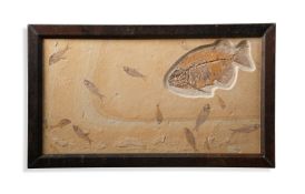
‡ PHAREODUS TESTIS (KNIGHTIA EOCAENA) Medium Eocene 50 m.a White River FMT Kemmerer Wyoming 51cm high, 86cm wide ■ After t...

Los 206
A MAP OF POOLE HARBOUR
A MAP OF POOLE HARBOUR 201.5 x 134cm (79¼ x 52¾ in.)

A 'FUJIYAMA' HANDSCROLL Japan, 19th century Depicting 19 individual views of Fujiyama, ink and colour on paper. 1280cm (504in) long. Footnotes: 日本...

Los 226
A Framed Georgian ? Linen Good Sized Fragment incorporating Deer and Swans. H 32cm x W 77.5cm
A Framed Georgian ? Linen Good Sized Fragment incorporating Deer and Swans. H 32cm x W 77.5cm