

Morel, Casparas Johannes (Casper) (Amsterdam 1798-1861) "Hollandse schoener"
Antike Landkarten kaufen
182 Los(e)
- Liste
- Galerie
-
182 Los(e)/Seite

Eerdmans, (Johan) (Sneek 1950) "Stilleven met appels en kruisbessen",

Twee schildpad lepeldoosjes, 19e eeuw.

Doolaard, Cornelis Jan (Poortugal 1944-) 'Interior',

Apol, Louis (in de manier van) "Winterlandschap",

Een 14 krt armband met 9 briljanten van totaal 0.36 crt G-VVS

Liang, Qiangli (Guangzhou 1964) "Twee vrouwen",

Schonk, Johannes Theodorus (Jan) (1889-1976) "St. Franciscus en de vogels",

Staller, Gerard Johan (Amsterdam 1880-1956) 'Two ladies on the market',

Rodenburg, Hendrikus Elias (1895-1987) "Westertoren Prinsengracht te Amsterdam",

Een houten scheepsmodel van de 'HMS Bounty', 20e eeuw.

Velzen van, Johannes Petrus (Johan) (1816-1853) "Rivierlandschap met molens"

Twee gestoken houten Birmese Boeddha's, midden 20e eeuw

Groningen, van Loes (1884-1970) "Stilleven van pioenrozen",

Los 307
Hoef, van Marcel "Hidden Space",
Hoef, van Marcel "Hidden Space",

Montijn, Jan (Oudewater 1924-2015) "Zonder titel",

Een natuurstenen sculptuur van salamander, modern/hedendaags, 20e eeuw.

't Gezigt van Jakobus / 't Gezigt van Agapius, Luyken 1740.

Een serie van zes zilveren theelepeltjes, suikerschep en taartvorkjes, 20e eeuw.

Los 1044
NOLLI, GIOVANNI BATTISTA, BENEDETTI, IGNACIO: "La topografia di Roma di Gio Battista Nolli".
NOLLI, GIOVANNI BATTISTA (Castiglione d'Intelvi 1701 - 1756 Rom); BENEDETTI, IGNACIO (Italien, 18. Jh.) : "La topografia di Roma di Gio Battista N...

Los 1072
WALSER, GABRIEL: "Canton Bern sive Illustris Helvetiorum Respublica Bernensis cum subditis suis et
WALSER, GABRIEL (Wolfhalden 1695 - 1776 Berneck) : "Canton Bern sive Illustris Helvetiorum Respublica Bernensis cum subditis suis et confinibus re...

Los 177
Austrian Photografer around 1920
Austrian Photographer around 1920, mountain views.

Geschichte des Siebenjährigen Krieges in Deutschland, by Haude und Spener Berlin 1793. First volume. With map. In leather hard cover with gilded i...

Herbert Boeckl (1894-1966)-Graphic map , with 19 black and white and coloured graphics. Numbered. On paper. In hard cover map. Edition around 1970...
![Charles I (King of England) Basilika [graece]. The Workes of King Charles the Martyr, by James Fl...](https://portal-images.azureedge.net/auctions-2025/forum-10467/images/9719e683-f854-4936-8f3c-b2ce00abb255.jpg?h=175)
Los 53
Charles I (King of England) Basilika [graece]. The Workes of King Charles the Martyr, by James Fl...
Charles I (King of England) Basilika [graece]. The Workes of King Charles the Martyr, 2 vol. in 1, engraved frontispiece, additional engraved titl...

Los 175
Cartographers.- Petermann (Augustus Heinrich, German cartographer, 1822-1878) Autograph Letter si...
Cartographers.- Petermann (Augustus Heinrich, German cartographer, 1822-1878) Autograph Letter signed, 1p., 8vo, Gotha, 20 February, 1874, discuss...
![Broadsides.- Nottingham Politics.- Paid Assassins!, printed broadside, [c.1866]; and 5 others on ...](https://portal-images.azureedge.net/auctions-2025/forum-10467/images/e35b47ab-f44e-41a6-b6ec-b2ce00abd21e.jpg?h=175)
Los 81
Broadsides.- Nottingham Politics.- Paid Assassins!, printed broadside, [c.1866]; and 5 others on ...
Broadsides.- Nottingham Politics.- Paid Assassins!, [c.1866] § All or None. To the Freemen of Nottingham and the Inhabitants Generally, [1839]; To...

Los 243
India.- Execution of the assassin Sher Ali.- Bombay Gazette Extra edition. Monday March 18, 1872....
India.- Execution of the assassin Sher Ali.- Bombay Gazette. Extra edition. Monday March 18, 1872...Execution of Shere Ali, handbill, folds, littl...

Los 173
Broadside printed on silk.- Banquetting Hall. Saturday, October 25, 1862, at 9 p.m. musical enter...
Broadside printed on silk in India.- Banquetting Hall. Saturday, October 25, 1862, at 9 p.m. musical entertainment to the Hon'Ble W.A. Morehead, f...

Los 30
Britain.- Cary (John) Cary's New and Correct English Atlas: being a New Set of County Maps, for J...
Britain.- Cary (John) Cary's New and Correct English Atlas: being a New Set of County Maps, engraved title and dedication, 47 engraved maps (hand-...

Los 96
Zoroastrianism.- Patrizi (Francesco) [Magia Philosophica hoc est Francisci patricii summi philoso...
Zoroastrianism.- Patrizi (Francesco) [Magia Philosophica hoc est Francisci patricii summi philosophi zoroaster], lacking title and supplied in man...

Los 193
Satirical rebus.- King George III.- Laurie & Whittle, publishers. Hierogliphick on the King's Bir...
Satirical rebus.- King George III.- Laurie & Whittle, publishers. Hierogliphick on the King's Birth-day, engraved 'Hierogliphick' and 'A Political...

Europe.- Jigsaw.- Philips' Series of Dissected Maps. Europe, lithographed map printed in colours, mounted on wood and dissected, 330 x 430mm., sli...

Los 33
England.- Ashburton (Charles Alfred) A New and Complete History of England, From the first Settle...
England.- Ashburton (Charles Alfred) A New and Complete History of England, From the first Settlement of Brutus ... To the Year 1793, engraved fro...

Atlas.- Lopez de Vargas Machuca (Tomas) Atlas Elemental Moderno, engraved pictorial title, 27 double-page engraved maps and plates, all but 2 hand...

Los 1034
Reichsamt für Landesaufnahme (Hrsg.)
Reichsamt für Landesaufnahme (Hrsg.)„Übersichtskarte des Deutschen Reiches 1935“, Reichsamt für Landesaufnahme/ Berlin 1935, 1:1000000, auf Leinen...

Los 1033
Konvolut
Konvolut„Dienststellenplan von Groß Berlin“, Vitalis Verlag 1946/ „Standart Luftbildkarte für Kraftfahrer Plan 25“, Deutsch-Amerikanische Petroleu...

Los 98
Karte Lauenburg
Karte LauenburgKarte „Duchè de Lauembourg l `Electeur de Hanover“, altcolorierter Kupferstich, gerahmt, 28,5 x 21,5 cm

Los 90
Ratzeburg
Ratzeburg„Inter Suspiria Luctus - Ratzeburg in Sachsen“, aus Meisners Schatzkästlein um 1630, Original Kupferstich, 7 x 14,5 cm, gerahmt

Los 995
Karl Baedeker
Karl Baedeker„Die Schweiz nebst den angrenzenden Teilen von Oberitalien, Savoyen und Tirol“, Handbuch für Reisende, Verlag von Karl Baedeker/ Leip...

Los 1149
Konvolut Kriegskarten
Konvolut Kriegskarten„Stritt`s Weltkarte“, K.Vowinkel Verlag/ Heidelberg-Berlin 1942/ „Weltkarte“, Verlag G.Westermann/ Berlin 1941/ „Die Kriegssc...

Los 1010
Carl Flemings Generalkarte No. 14
Carl Flemings Generalkarte No. 14„Schleswig Holstein, Mecklenburg, Hamburg, Bremen und Lübeck“, Entworfen v. F. Handtke, 83 x 65 cm, auf Leinen zw...
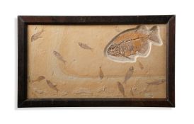
‡ PHAREODUS TESTIS (KNIGHTIA EOCAENA) Medium Eocene 50 m.a White River FMT Kemmerer Wyoming 51cm high, 86cm wide ■ After t...

Los 206
A MAP OF POOLE HARBOUR
A MAP OF POOLE HARBOUR 201.5 x 134cm (79¼ x 52¾ in.)

Atlanten - - Riedig, M. Taschen-Atlas über alle Theile der Erde in 24 Karten gezeichnet von M. Riedig. Mit 24 (23 grenzkolorierten) Karten. Leipzi...

A 'FUJIYAMA' HANDSCROLL Japan, 19th century Depicting 19 individual views of Fujiyama, ink and colour on paper. 1280cm (504in) long. Footnotes: 日本...

Los 616
Ansichten - 20 Kupfer & 7 Lithos
Ansichten.- Konvolut von 22 Blättern mit 27 Stadtansichten, davon 20 Kupferstiche (davon 3 koloriert) und 7 Lithographien. Zwischen 1575 und 1833....

Los 624
Merian - Ingelheim
Rheinland-Pfalz.- Ingelheim. Kupferstich von M. Merian, um 1645. 20 x 31 cm.Erhöhte Gesamtansicht der Stadt am Rhein, im Vordergrund links ein Bau...

Los 630
Mappe-Monde Charpente
Weltkarten.- Mappe-Monde Pour indiquer la Charpente des deux Continents et les principales divisions naturelles de l'Ocean... Stahlstichkarte aus ...

Schleswig-Holstein.- Erhebung.- Konvolut von 8 altkolorierten Lithographien (davon 1 doppelt) zur Schleswig-Holsteinischen Erhebung. Hamburg, bei ...

Skandinavien.- 4 Kupferstichkarten (davon 1 teilkoloriert) aus F.A. Schraembls 'Allgemeiner großer Atlas'. Wien, um 1800. Jeweils 23,5 x 29.5 cm. ...

Los 623
Merian - 7 x Münster Westphalen
Nordrhein-Westfalen.- Münster In Westphalen. Vor der Belägerung / Belägerung Münster. So von Iro ... und sich den 23 Octobri dißes Jahrs güttliche...

Los 621
Bomsdorff/Baade - Mecklenburg
Mecklenburg.- Topographische Special-Karte der Grossherzogthümer Mecklenburg-Schwerin und Mecklenburg-Strelitz ... von R. von Bomsdorff revid. von...

Los 628
Ratzeburg - 4 Ansichten
Schleswig-Holstein.- Ratzeburg.- Konvolut von 4 koloriert(en) Ansichten. Jeweils unter Passepartout. 1. Kupferstich aus Kieser-Meissner, um 1623. ...

Los 618
Konvolut von 250 Stahlstichen
Ansichten.- Konvolut von ca. 250 Stahlstichen (teils Dubletten, vereinzelt koloriert) mit Ansichten aus Deutschland. Um 1860. Alle unter schlichte...

Russland.- Vue de la néva, du port, et de la bourse de St. Pétersbourg. An 1812. Altkoloriert Aquatintaradierung von M.-F. Demane-Démartrais von ...

Los 619
Spaichingen - Lithographie
Baden-Württemberg.- Spaichingen. Lithographie, um 1840. 20,5 x 29,5 cm.Ansicht der Kleinstadt bei Schefold von Südwesten. Im Hintergrund der Dreif...

Ansichten.- Konvolut von 46 Stahlstichen (wenige Dubletten) mit verschiedenen Ansichten aus aller Welt. Um 1860. Alle unter schlichtem Passepartou...

Deutschland.- Konvolut von 21 Kupferstichplänen (davon 4 altkoloriert, 1 doppelt) und 2 Stahlstichplänen (davon 1 altkoloriert) verschiedener Städ...

Los 627
Ruths - Christian VIII.
Schleswig-Holstein.- Erhebung.- Vernichtung des dänischen Linienschiffes Christian VIII. von 84 Kanonen, durch 10 schleswig-holsteinische u. 6 nas...