Highlight


Handcol. engr., 47 x 57 cm, depicting an armillary sphere, a celestial globe and a terrestrial globe, Nuremburg, J.B. Homann, ca. 1720, framed und...

Handcol. engr., 47 x 57 cm, depicting an armillary sphere, a celestial globe and a terrestrial globe, Nuremburg, J.B. Homann, ca. 1720, framed und...
Du déjeuner Pullman au diner. Paris-Bruxelles-Amsterdam. Paris, Hachard & Cie, 1927. 106 x 75 cm. Corners and minor dam. to folds, professionally ...
Landkarte (Kupferstich) Afrika By H. Moll Geograph Authentizitätszertifikat 1744Laut Wikipedia war Herman Moll ein britischer Kupferstecher, ...
Landkarte Kupferstich Benjamin Baker, Deutschland um 1740 - Heiliges Römisches Reich Deutscher NationAlte Karte von Deutschland von B. Baker, um 1...
Alte Karte Kupferstiche von Afrika von Thomas Jefferys, um 1749Thomas Jefferys (auch: T. Jefferies, Jeffery, Jeffereys, Jeffreys oder Gefferys; *...
Landkarte Kupferstich von John Rapkin Victoria or Port Phillip Australien, um 1850 Landkarte von Victoria or Port Phillip Australien mit dekorativ...
Karte des Mosambikkanals mit Madagaskar und Afrikas Küsten, Kupferstich um 1870 von Rigobert BonneCarte du Canal de Mosambique contenant l'isle de...
Landkarte "Australia with the British Settlements", um 1835Kupferstich einer detaillierten Karte von Australien mit Einlegekarten von Swan River, ...
Colmar, Gesamtansicht, Kupferstich, 10 x 33 cm, von Merian, 17. Jh., R
Füssen, 3 Teilansichten, 2 Stahlstiche, 1 handcolorierter Holzstich, verschiedene Größen (größte Abb. 22 x 16,5 cm), 19. Jh., R
Kempten, Gesamtansicht, Kupferstich, handcolor., 34 x 45 cm, von Braun & Hogenberg, 16. Jh., gebräunt, P
Landkarte "Apmliss et Prudentiss...Leutkirch", Kupferstich, 26,5 x 34 cm, von Merian, um 1650, gebräunt, fleckig, R
Landkarte "Carte Generale de la Pologne (Polen)", Kupferstich, handcolor., 30 x 44,5 cm, von M. Rizzi Zannoni, 18. Jh., R
Landkarte "Ducatus Andegavensis (Anjou)", Kupferstich, handcolor., 38 x 49 cm, von Bleau, um 1630, Ränder gebräunt
Landkarte "Le Tyrol", Kupferstich, handcolor., 48 x 54 cm, von P. Santini, 1778, R
Landkarte "Les deux poles arctique... et antarctique...", Kupferstich, handcolor., 38,5 x 53,5 cm, von Pruthenus, nach Sanson, um 1700, Knick- und...
Landkarte "Poloniae Regnum (Polen)", Kupferstich, handcolor., 19,5 x 25,5 cm, von M. Seutter, 18. Jh., R
Landkarten, 2 Stück "Vermandois und Calais", 2 Kupferstiche zu einem Blatt zusammengefügt, Gesamt 44,5 x 55 cm, bei J.B. Vrients, Antwerpen, um 16...
Landkarten, 6 Stück, verschiedene Techniken und Größen (größte Karte 120 x 78 cm), u.a. Balkan, Ravenstein, Insel Rügen, 18.-20. Jh., teils leicht...
Moskau, Panoramaansicht vom Kreml, Radierung, 26 x 55 cm, undeutl. handsign., dat. 1997, num. 9/20, R
Ortsansichten, 7 Stück - Klöster, 7 Kupferstiche, je ca. 7 x 13 cm, u.a. Kloster Kastell, Rottenbuch, Spenshart, Wessobrunn, 18. Jh., gebräunt, je...
Pompeii, Teilansicht, Kupferstich, handcolor., 28 x 40 cm, von Berthault, 18. Jh., R
Raab in Oberungarn, Gesamtansicht, Kupferstich, 14,5 x 23 cm, bei Jos. Eder, Wien, 18. Jh., R
Salernes, Teilansicht, Kupferstich, handcolor., 28 x 40 cm, von Miamel, 18. Jh., R
St. Gallen, Ansicht aus der Vogelschau, Kupferstich, 15 x 22 cm, von Bodenehr, 18. Jh., R
Trontheim (Dronheem), Ansicht aus der Vogelschau, Kupferstich, 27,5 x 33,5 cm, von Dahlberg, um 1700, leicht gebräunt und fleckig
(Anversa, 1682 - 1716)Veduta costiera con vascelli e figure Olio su tela applicata su tavola, cm 45,5X66Provenienza:Londra, Sotheby's, 13 luglio 1...
A WWII Second World War British ' escape ' silk map of Eastern Europe & Greece sheets 43 H and G. Scale 1;100,000. Folds to pocket handkerchief si...
Metal Sign Motorcycle Repair & Sales. Overall good condition the dirt and rust on the sign are printed effects instead of actual wear. Dimensions ...
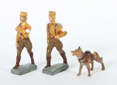
2 SA Soldaten mit HundLineol und Elastolin, 7,5-cm-Serie, SA, Lineol Fahnenträger ohne Fahne; Lineol Maschierer; Elastolin Sanitäts-Hund; min. Al...
Cochin aus Pufendorf„Mölln“ - Gesamtansicht über den Möllner See, im Vordergrund Reiterregiment, über der Ansicht Benennung der einzelnen Einheite...
Matthäus Merian(Basel 1593 - 1650 in Langenschwalbach, schweizerisch-deutscher Kupferstecher u. Verleger) „München - Monachium Regi Suecorum Certi...
Matthias Merian„Ratzebourg“, Bombardierung der Stadt durch die Dänen 1693, Original Kupferstich aus Merian's "Theatrum Europaeum“ um 1700, 18 x 23...
Stadtplan La Rochelle„Der Mächtigen und Vesten Statt Roschell wahrhafftige Abcontrafaktur“, Sebastian Munster 1544, aus Munsters Cosmographia, Ori...
Matthäus Merian„Plan der Bataille bey Gadebusch“ - Von denen Schweden unter Comando des H. General Stenbocks , über die Dänen u. Sachsen. Sieghaft...
Matthäus Merian(Basel 1593 - 1650 in Langenschwalbach, schweizerisch-deutscher Kupferstecher u. Verleger) „Gadebusch“, Origianal Kupferstich aus „...
Kupferstich Ratzeburg„Ansicht von Ratzeburg“ - Sr. Herzoglichen Durchlaucht dem regierenden Herzog von Mecklenburg Strelitz gewidmet von C.J. Erns...
Matthias Merian„Die Stadt Ratzeburg welche vom König von Dänemack Ao. 1693 im Monat Augusti bombardiret worden“, Original Kupferstich aus Merian's...
Gerdt Hane(Kupferstecher d. 16. Jh.) „Ratzeburgk“, Original handcolorierter Kupferstich aus Braun/ Hogenberg, verlegt Köln 1588, 33 x 40 cm, gerah...
(Anversa, 1708 - 1776)Adorazione dei MagiOlio su rame, cm 35,6X29,2Provenienza:Londra, Philips, 16 aprile 1991, lotto 114 (come Balthasar Beschey)...
M.C. Escher "Ascending and Descending" Print Measures 9.5 x 12 inches Mounted to same size cardstock
(Anversa, 1620 - 1668) Ritratto di astronomo con sfera armillareFirmato in maniera indistinta in basso a sinistraOlio su tela, cm 42X34Provenienza...
Cartography.- Cary (John) A New Map of England...1821, hand-coloured engraved map, dissected and mounted on linen, c.555 x 510mm., lightly soiled,...
Schleswig Holstein. Nordfriesland. Original kolorierte Kupferstichkarte von Joh. Mejer aus C. Danckwerth, Newe Landesbeschreibung ..., 1652. 2 Kar...
Original antique map of the island of Santo Domingo on thick brown paper published months after Toussaint Louverture's War of the Knives rebellion...
Beautiful antique hand-colored engraved map of England and Wales with part of Scotland including the new lines of canals, rail roads etc. Publishe...
This group of engravings includes: a W.P Blake U.S. Coast Survey Map showing the vicinity of the Golden Gate off the coast of San Francisco, Calif...
This group of five antique engraved maps include one color engraving of the West Indies on Mercator's Projection published in 1820 by Sherwood, Ne...
(Losanna, 1818 - Ginevra, 1898) Testa di SansoneOlio su tela, cm 51X41
This group includes three antique engravings: one small map of South Farallon Island with illustrations of the island's topography. Engraved by G....
Set of two engraved maps including one preliminary chart of the Savanah River, Georgia Coast Line with the key on the upper right side. Dimensions...
This set includes original engraved map with a survey of the Beaufort River in South Carolina. Dimensions: 29.5"L x 26.5"H. Another map features t...
This group of original engravings include: a small sketch of the survey of the Coast of Florida and Cedar Key Bay; a chart of St. Andrews Bay; A c...
A collection of x4 WWII Second World War British War Office Ordnance Survey maps. All dated 1940 comprising Hull, Great Driffield & Bridlington, Y...
A collection of approximately x80 RAF Royal Air Force and wartime OS maps comprising x20 RAF maps from the 1939-45 period including maps of Englan...
Reisen. Deutschlandkarte. Roost, J. B. Neue Wand – Karte von Deutschland den Königreichen Holland u. Belgien und der Schweiz, sammt den angrenzend...
Nicolaes Despars (1522-1597): 'Chronyke van Vlaenderen...', Bruges, 1736, 2 vol.4to. Full title: 'Chronyke van Vlaenderen, vervattende, haere v...
Coronelli, Vincnezo Maria1650-1718, partiell kolorierte Karte wohl aus Corso Geografico Universale mit schöner Kartusche, Corso del Reno, Del Pala...
Karte Tertia Asiae Tabula15. Jhd., Tertia Asiae Tabula, stellenweise kolorierte Ptolemaeische Karte wohl nach d. Cosmographia von Ptolemäus, Gebr....