


ATTRIBUTED TO DONG GAO (1740-1818) Two Views of the Yangzi River Each ink and color on paper, matted, framed and glazed, inscribed with a title an...
Sammlerobjekte Auktionen
Beliebte Kategorien
Antike Landkarten
Musikinstrumente & Memorabilia
Banknoten & Wertpapiere
Sport Memorabilia & Ausrüstungen
Briefmarken
Schreibgeräte
Kameras & Fotoausrüstungen
Unterhaltung Memorabilia
Religiöse & Sakrale Kunst
Wissenschaftliche Instrumente
Waffen, Rüstungen & Militaria
Wein & Spirituosen
Präparate & Naturkundliches
Küchenutensilien
Werkzeug
Eisenbahngeschichte
Ausgewählte Auktionen
Kommende Auktionen


35 Los(e)
Sortieren nach:
- Kategorie,
- Land
- Liste
- Galerie
-
35 Los(e)/Seite

Los 12
PRESENTATION COPY. SAINT-SIMON, HENRI DE. Du System Industriel. Paris: Chez Antoine-Augustin Ren...
PRESENTATION COPY. SAINT-SIMON, HENRI DE. Du System Industriel. Paris: Chez Antoine-Augustin Renouard, 1821. 8vo (215 x 139 mm). Contemporary pub...

Framed Fraktur Portrait of George Washington, America, mid-19th century. Equestrian portrait in blue, red, and black ink on trimmed sheet of wove...

Los 58
ANSON, GEORGE, BARON. 1697-1762. A Voyage Round the World, in the Years MDCCXL, I, II, III, IV. ...
ANSON, GEORGE, BARON. 1697-1762. A Voyage Round the World, in the Years MDCCXL, I, II, III, IV. London: For the Author by John and Paul Knapton, 1...

Los 66
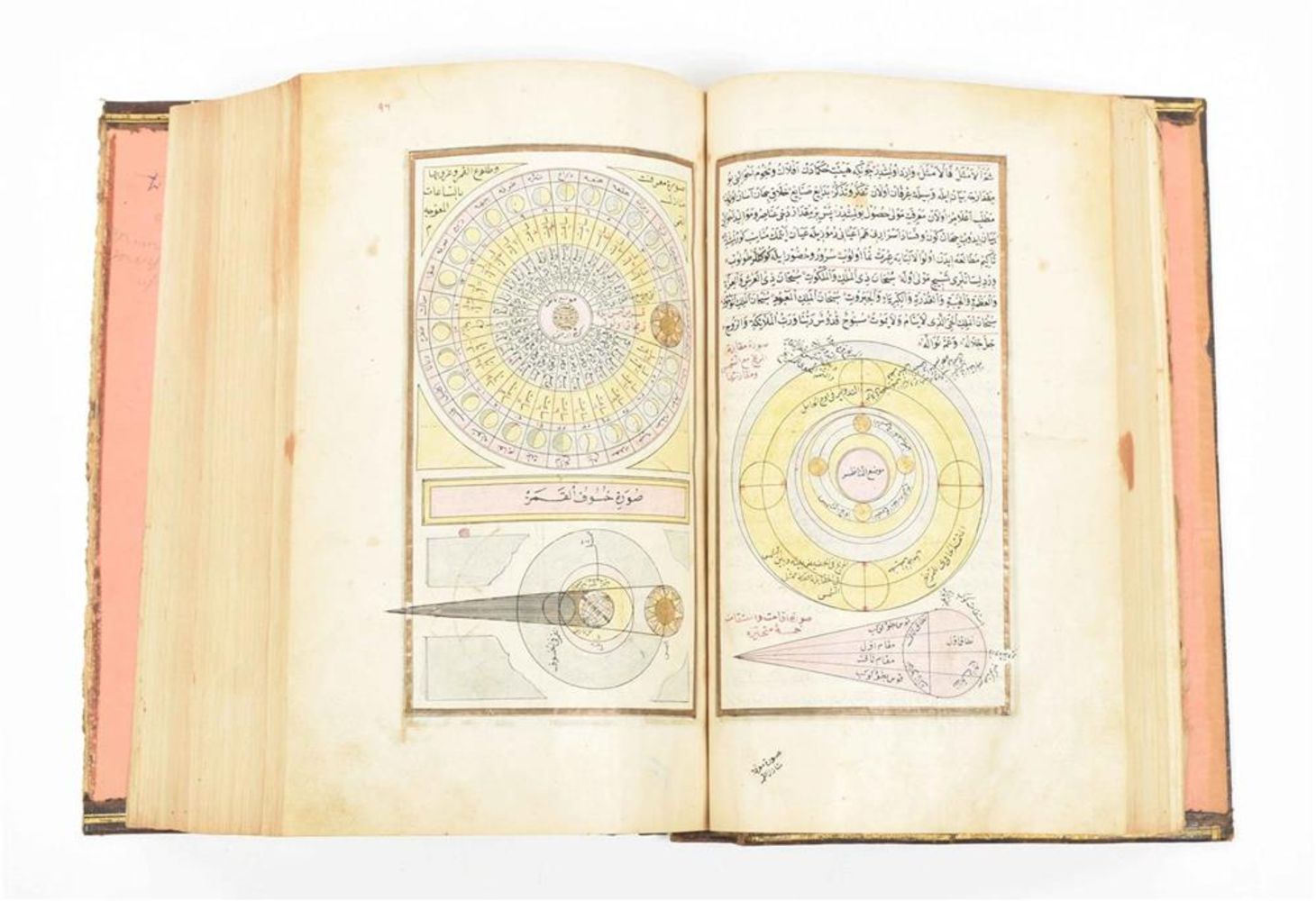
CELLARIUS, ANDREAS. 1596-1665. Harmonia macrocosmica seu atlas universalis et novus, totius uni...
66CELLARIUS, ANDREAS. 1596-1665. Harmonia macrocosmica seu atlas universalis et novus, totius uni...
CELLARIUS, ANDREAS. 1596-1665. Harmonia macrocosmica seu atlas universalis et novus, totius universi creati cosmographiam generalem, et novam exhi...

Los 67
CELLARIUS, ANDREAS. 1596-1665. Hypothesis Ptolemaica Sive Communis Planetarum. Amsterdam: J. Ja...
67CELLARIUS, ANDREAS. 1596-1665. Hypothesis Ptolemaica Sive Communis Planetarum. Amsterdam: J. Ja...
CELLARIUS, ANDREAS. 1596-1665. Hypothesis Ptolemaica Sive Communis Planetarum. Amsterdam: J. Jansson, 1661. Engraved map with early hand coloring...

Los 68
CELLARIUS, ANDREAS. 1596-1665. Circa Orbem Terrarum Spiralis Revolutio. Amsterdam: J. Jansson, 1...
CELLARIUS, ANDREAS. 1596-1665. Circa Orbem Terrarum Spiralis Revolutio. Amsterdam: J. Jansson, 1661. Engraved map with hand-coloring, 435 x 505 m...

Los 69
CELLARIUS, ANDREAS. 1596-1665. Planisphaerivm Ptolemaicvm Sive Machina Orbivm Mvndi. Amsterdam: ...
CELLARIUS, ANDREAS. 1596-1665. Planisphaerivm Ptolemaicvm Sive Machina Orbivm Mvndi. Amsterdam: Schenk and Valk, c.1708. Engraved map with early ...

Los 70
CELLARIUS, ANDREAS. 1596-1665. Scenographia systematis mundani Ptolemaici. Amsterdam: Schenk and...
CELLARIUS, ANDREAS. 1596-1665. Scenographia systematis mundani Ptolemaici. Amsterdam: Schenk and Valk, c.1708. Engraved map with early hand color...
Los 71
CELLARIUS, ANDREAS. 1596-1665. Scenographia Compagis Mvndanae Brahea. Amsterdam: Schenk and Valk...
CELLARIUS, ANDREAS. 1596-1665. Scenographia Compagis Mvndanae Brahea. Amsterdam: Schenk and Valk, c.1708. Engraved map with early hand-coloring, ...

Los 72
CELLARIUS, ANDREAS. 1596-1665. Corporum Coelestium Magnitudines. Amsterdam: Schenk and Valk, c.1...
CELLARIUS, ANDREAS. 1596-1665. Corporum Coelestium Magnitudines. Amsterdam: Schenk and Valk, c.1708. Engraved map with early hand coloring, 420 x...
![PEARY'S COPY OF AN EARLY NORTH AMERICAN MAP. PEARY, ROBERT E. 1856-1920.] DOBBS, ARTHUR. 1689-17...](https://portal-images.azureedge.net/auctions-2024/bonham11059/images/40e88eff-b162-4483-a18e-b1920118f41b.jpg?h=175)
Los 81
PEARY'S COPY OF AN EARLY NORTH AMERICAN MAP. PEARY, ROBERT E. 1856-1920.] DOBBS, ARTHUR. 1689-17...
PEARY'S COPY OF AN EARLY NORTH AMERICAN MAP. PEARY, ROBERT E. 1856-1920.] DOBBS, ARTHUR. 1689-1765. A Map of Part of North America From the Latitu...

Los 92
WORLD MAP. LOON, JAN VAN. C 1611-1686. Orbis Terrarum Nova et Accuratissima tabula. [Oxford: Mo...
92WORLD MAP. LOON, JAN VAN. C 1611-1686. Orbis Terrarum Nova et Accuratissima tabula. [Oxford: Mo...
WORLD MAP. LOON, JAN VAN. C 1611-1686. Orbis Terrarum Nova et Accuratissima tabula. [Oxford: Moses Pitt, 1680.] Engraved hand-colored double-hem...

M.C. Escher "Ascending and Descending" Print Measures 9.5 x 12 inches Mounted to same size cardstock


Los 182
DITTERLINE, THEODORE. 1816-1883. Sketches of the Battles of Gettysburg with Explanatory Map. New...
DITTERLINE, THEODORE. 1816-1883. Sketches of the Battles of Gettysburg with Explanatory Map. New York: C.A. Alvord, 1863. 8vo (183 x 114 mm). Chr...

Los 191
COLLECTION OF WORLD TEXTILES INCLUDING TOILE (MOUNTED), Europe, America, India, China, Japan, In...
COLLECTION OF WORLD TEXTILES INCLUDING TOILE (MOUNTED), Europe, America, India, China, Japan, Indochina Circa early 19th century through mid 20th ...

This group of six original engraved maps include four small sketches of the Western Coast of Oregon and California. The largest measures 14"L x 10...

This original engraved map is a Survey of Chart no.55 from Hunting island to Ossabaw Island from South Carolina and Georgia. Issued: 1873Dimension...

Group of three original antique maps. The smallest engraving depicts the Gulf of Mexico's Coast Line and was made by A.D. Bache. Dimensions: 25.25...

This group of engravings includes: a U.S. Coast Survey Map showing the progress of the survey of Cedar Keys, Bahia Honda, Key Biscayne, Key West &...

This group includes an engraved map of a Florida Reefs chart from Key Biscayne to Carysfort Reef done under the command of Lieuts. J. Rodgers & T....

Two engravings that include a Survey Map of the Coastline of Suisun Bay, California with a key on the upper left. Dimensions: 33.5"L x 20.5"H. The...

This antique group of engraved maps include: a large map of Muskeget Channel and Martha's Vineyard by A.D. Bache, Superintendent of the Survey of ...

Two antique original maps engravings of a Survey of Biloxi Bay in Mississippi. Dimensions: 19"L x 16"H. It also includes a Survey of Louisiana and...

A PICCHAWAI OF SHRI NATHJI DURING THE ANNAKUT FESTIVAL India, Nathdwara, 19th/20th century Opaque watercolor on cloth; framed. 66 1/2 x 54 1/4in ...

M.C. Escher (Depth) Colored Print 11.75 x 8.5 inches Mounted to same size cardstock.

Measures 36 x 22 inches The Winslow House

Measures 36 x 22 inches Studio of Frank Lloyd Wright

Measures 39 x 30 inches

Measures 36 x 22 1/2 inches

Measures 36 x 24 inches

Measures 36 x 24 inches

Los 1104
Six French & Indian War Maps/Views,
Six French & Indian War Maps/Views, London, England, 1758-59. A Plan of the City & Harbour of LOUISBOURG; shewing that part of GABARUS BAY in whic...

Los 1119
Four 18th Century Maps of America.
Four 18th Century Maps of America. A PLAN of the TOWN AND CHART of the HARBOUR of BOSTON Exhibiting a View of the Islands Castle Forts and Entran...